Area code 661

Last updated
Numbering plan areas in California (blue) and border states. Area code 661 is shown in red. Area code 661.svg458/541775702928442/760916/279530707209559831805661858909951619213323707916/279415650510/341925408209831805661442/760310/424747/818626909951949562657/714
Numbering plan areas in California (blue) and border states. Area code 661 is shown in red.

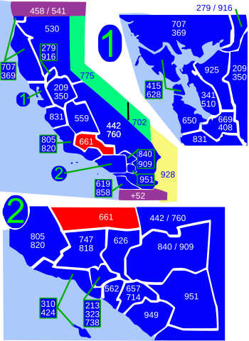
Area code 661 is a telephone area code in the North American Numbering Plan for the southern part of the San Joaquin Valley and for the far northern part of the Los Angeles metropolitan area. The numbering plan area comprises most of Kern County, most of northern Los Angeles County (specifically the Santa Clarita Valley, the Antelope Valley and the surrounding mountains), and small parts of Ventura County, Santa Barbara County, and Tulare County. It was created in an area code split of area code 805 on February 13, 1999.

Contents

Principal cities in the numbering plan area are Bakersfield, Palmdale, Santa Clarita, and Lancaster.

Service area

Kern County

Los Angeles County

Santa Barbara County

Tulare County

See also

Related Research Articles

<span class="mw-page-title-main">Los Angeles County, California</span> Most populous county in the United States and in California

Los Angeles County, officially the County of Los Angeles, and sometimes abbreviated as L.A. County, is the most populous county in the United States, with 9,861,224 residents estimated in 2022. Its population is greater than that of 40 individual U.S. states. Comprising 88 incorporated cities and many unincorporated areas within a total area of 4,083 square miles (10,570 km2), it is home to more than a quarter of Californians and is one of the most ethnically diverse U.S. counties. The county's seat, Los Angeles, is the second most populous city in the United States, with about 3.9 million residents. Being the home of the U.S. motion-picture industry, since its inception in the early 20th century, has given the county global prominence.

<span class="mw-page-title-main">Rosamond, California</span> Unincorporated community in Kern County, California

Rosamond is an unincorporated community in Kern County, California, US, near the Los Angeles county line. Rosamond is part of Greater Los Angeles and is located in the Mojave Desert just north of Lancaster and Palmdale, two of the largest cities in Antelope Valley. As of the 2010 Census, Rosamond's population was 18,150. For statistical purposes, the United States Census Bureau has defined Rosamond as a census-designated place (CDP).

<span class="mw-page-title-main">Acton, California</span> Census designated place in Los Angeles County, California

Acton is an unincorporated census-designated place in Los Angeles County, California, near the Antelope Valley. According to the 2010 census, Acton had a population of 7,596.

<span class="mw-page-title-main">Lancaster, California</span> City in California, United States

Lancaster is a charter city in northern Los Angeles County, in the Antelope Valley of the western Mojave Desert in Southern California. As of the 2020 census, the population was 173,516, making Lancaster the 153rd largest city in the United States and the 30th largest in California. Lancaster is a twin city with its southern neighbor Palmdale; together, they are the principal cities within the Antelope Valley region.

<span class="mw-page-title-main">Palmdale, California</span> City in California, United States

Palmdale is a city in northern Los Angeles County in the U.S. state of California. The city lies in the Antelope Valley of Southern California. The San Gabriel Mountains separate Palmdale from the Los Angeles Basin to the south.

<span class="mw-page-title-main">Quartz Hill, California</span> Census-designated place in California, United States

Quartz Hill is a census-designated place (CDP) in Los Angeles County, California, United States. The population was 10,912 at the 2010 census, up from 9,890 at the 2000 census. The name is also shared with the neighboring district areas of its border cities, Palmdale, and Lancaster. Quartz Hill was once home to the Quartz Hill Airport. According to the Greater Antelope Valley Economic Alliance report of 2009, the Palmdale / Lancaster urban area of which Quartz Hill is a part, has a population of 483,998.

<span class="mw-page-title-main">Antelope Valley</span> Valley in Southern California, United States

The Antelope Valley is located in northern Los Angeles County, California, United States, and the southeast portion of California's Kern County, and constitutes the western tip of the Mojave Desert. It is situated between the Tehachapi, Sierra Pelona, and the San Gabriel Mountains. The valley was named for the pronghorns that roamed there until they were all eliminated in the 1880s, mostly by hunting, or resettled in other areas. The principal cities in the Antelope Valley are Palmdale and Lancaster.

<span class="mw-page-title-main">Santa Clarita Valley</span> Valley in Los Angeles County, California, United States

The Santa Clarita Valley (SCV) is part of the upper watershed of the Santa Clara River in Southern California. The valley was part of the 48,612-acre (19,673 ha) Rancho San Francisco Mexican land grant. Located in Los Angeles County, its main population center is the city of Santa Clarita which includes the communities of Canyon Country, Newhall, Saugus, and Valencia. Adjacent unincorporated communities include Castaic, Stevenson Ranch, Val Verde, and the unincorporated parts of Valencia.

<span class="mw-page-title-main">California State Route 14</span> State highway in Los Angeles and Kern counties in California, United States

State Route 14 is a north–south state highway in the U.S. state of California that connects Los Angeles to the northern Mojave Desert. The southern portion of the highway is signed as the Antelope Valley Freeway. The route connects Interstate 5 on the border of the city of Santa Clarita to the north and the Los Angeles neighborhoods of Granada Hills and Sylmar to the south, with U.S. Route 395 (US 395) near Inyokern. Legislatively, the route extends south of I-5 to SR 1 in the Pacific Palisades area of Los Angeles; however, the portion south of the junction with I-5 has not been constructed. The southern part of the constructed route is a busy commuter freeway serving and connecting the cities of Santa Clarita, Palmdale, and Lancaster to the rest of the Greater Los Angeles area. The northern portion, from Vincent to US 395, is legislatively named the Aerospace Highway, as the highway serves Edwards Air Force Base, once one of the primary landing strips for NASA's Space Shuttle, as well as the Naval Air Weapons Station China Lake that supports military aerospace research, development and testing. This section is rural, following the line between the hot Mojave desert and the forming Sierra Nevada mountain range. Most of SR 14 is loosely paralleled by a rail line originally built by the Southern Pacific Railroad, and was once the primary rail link between Los Angeles and Northern California. While no longer a primary rail line, the southern half of this line is now used for the Antelope Valley Line of the Metrolink commuter rail system.

<span class="mw-page-title-main">California State Route 138</span> Highway in California

State Route 138 is an east–west state highway in the U.S. state of California that generally follows the northern foothills of the San Gabriel Mountains and the western Mojave Desert. The scenic highway begins in the west at its junction with Interstate 5 located south of Gorman in the Sierra Pelona Mountains, continues eastward through the Antelope Valley and Cajon Pass, to its junction with State Route 18 in the east, located in the San Bernardino Mountains south of Crestline.

<span class="mw-page-title-main">Neenach, California</span> Unincorporated community in California, United States

Neenach is an agricultural settlement in northwestern Los Angeles County, California, United States, with a population of about 800. It is facing a massive change with the proposed construction of a 23,000-home planned community to its north called Centennial.

<span class="mw-page-title-main">Antelope Valley Line</span> Metrolink commuter rail line linking Downtown Los Angeles to Northern Los Angeles County

The Antelope Valley Line is a commuter rail line that serves the Northern Los Angeles County area as part of the Metrolink system. The northern segment of the line is rural in character because it travels through the sparsely populated Soledad Canyon between Santa Clarita and Palmdale, serving the small community of Acton along the way. Other portions of its route parallel the former US Route 6, now San Fernando Road and Sierra Highway. This is the only Metrolink line contained entirely within Los Angeles County.

<span class="mw-page-title-main">Soledad Canyon</span> Canyon in Los Angeles County, California, United States

Soledad Canyon is a long narrow canyon/valley located in Los Angeles County, California between the cities of Palmdale and Santa Clarita. It is a part of the Santa Clara River Valley, and extends from the top of Soledad Pass to the open plain of the valley in Santa Clarita. The upstream section of the Santa Clara River runs through it.

<span class="mw-page-title-main">Lake Hughes, California</span> Unincorporated community in California, United States

Lake Hughes is an unincorporated community in northern Los Angeles County, California. It is in the Sierra Pelona Mountains, northwest of Palmdale and north of the Santa Clarita Valley, in the Angeles National Forest. It is on the sag pond waters of Lake Hughes and Elizabeth Lake. The community is rural in character, with a population of 649 in 2010, but also has a strong recreational element centered on the three lakes in the vicinity. The community of Elizabeth Lake is located just east of Lake Hughes, sharing the same ZIP code.

FC Santa Clarita (FCSC) is an American soccer team based in Santa Clarita, California, United States. FC Santa Clarita also known as the Santa Clarita Storm make just north of Los Angeles home, as they compete in the United Premier Soccer League (UPSL). Santa Clarita FC announced they joined the UPSL’s Western Conference November 5, 2014. The team is owned by American businessman Gary Brunner, President and CEO of United Sports International Inc. The team is Santa Clarita’s only sports franchise calling the area home with the encouragement and support of the city.

<span class="mw-page-title-main">Sierra Pelona Ridge</span> Mountain range of the Transverse Ranges in California, United States

The Sierra Pelona, also known as the Sierra Pelona Ridge or the Sierra Pelona Mountains, is a mountain ridge in the Transverse Ranges in Southern California. Located in northwest Los Angeles County, the ridge is bordered on the north by the San Andreas fault and lies within and is surrounded by the Angeles National Forest.

<span class="mw-page-title-main">Lancaster station (California)</span>

Lancaster station is owned by and located in the city of Lancaster, California. It serves as a transfer point for several public transportation bus routes as well as the final Metrolink train station on the Antelope Valley Line that originates 69 miles (111 km) away in downtown Los Angeles, at Union Station.

<span class="mw-page-title-main">Newhall station</span> Train station in Santa Clarita, California, US

Newhall station is an intermodal hub in the Newhall neighborhood of Santa Clarita, California. The station is served by Metrolink's Antelope Valley Line operating between Los Angeles Union Station and Lancaster, Amtrak Thruway buses connecting to/from San Joaquins trains in Bakersfield, and serves as a transfer point in the City of Santa Clarita Transit bus system.

<span class="mw-page-title-main">California's 23rd State Senatorial district</span> American legislative district

California's 23rd State Senatorial district is one of 40 California State Senate districts. It is currently represented by Republican Rosilicie Ochoa Bogh of Yucaipa.

<span class="mw-page-title-main">High Desert (California)</span> Geographic area of southern California

High Desert is a vernacular region with non-discrete boundaries covering areas of the western Mojave Desert in Southern California. The region encompasses various terrain with elevations generally between 2,000 and 4,000 ft above sea level, and is located just north of the San Gabriel, San Bernardino, and Little San Bernardino Mountains.

References

    California area codes: 209, 213/323, 279/916, 310/424, 341/510, 408/669, 415/628, 442/760, 530, 559, 562, 619/858, 626, 650, 657/714, 661, 707, 747/818, 805/820, 831, 840/909, 925, 949, 951
    North: 559
    West: 805/820 661East: 442/760
    South: 805/820, 747/818, 626

    35°00′N118°42′W / 35°N 118.7°W / 35; -118.7