Topatopa Mountains

Last updated
Topatopa Mountains [1]
Topa Topa Mountains
The Pink Moment on Topa Topa from Upper Ojai.jpg
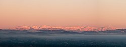
"The Pink Moment" on the Topa Topa bluffs, as viewed from Upper Ojai.
Highest point
Peak Hines Peak
Elevation 6,716 ft (2,047 m)
Coordinates 34°31′48″N119°02′35″W / 34.530°N 119.043°W / 34.530; -119.043 Coordinates: 34°31′48″N119°02′35″W / 34.530°N 119.043°W / 34.530; -119.043
Geography
Relief map of California.png
Red triangle with thick white border.svg
Topatopa Mountains [1]
CountryUnited States
State California
County Ventura
Parent range Transverse Ranges
Borders on Sierra Pelona Mountains and Sierra Madre Mountains

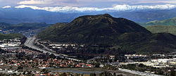
The Topatopa Mountains are a mountain range in Ventura County, California, north of Ojai, Santa Paula, and Fillmore. They are part of the Transverse Ranges of Southern California.

Contents

Etymology

A name for the mountains was first inscribed within the archives of Mission Basilica San Buenaventura in 1943, citing a nearby Chumash ranchería named "Si-toptopo". In 1945, American linguist and ethnologist John Peabody Harrington noted that "topa" is a Chumash word meaning "reed" or "rush". [2]

Geography

The Topatopa Mountains lie in an east–west direction east of the Sierra Madre Mountains, and west of the Sierra Pelona Mountains. To the south lies the Santa Clara River Valley into which various creeks drain starting in the mountains into the Santa Clara River. The range reaches an elevation of 6,716 feet (2,047 m) at Hines Peak, about six miles north of Thomas Aquinas College. Snow frequently falls on the high peaks during winter.

Hydrology

Several major tributaries of the Santa Clara River flow down from the Topatopa Mountains, the largest being Piru Creek and Sespe Creek.

Lake Piru is the only major reservoir located within the mountains.

Natural history

The Topatopa Mountains are within the southern Los Padres National Forest. The Sespe Wilderness Area, and the Sespe Condor Sanctuary, are primarily within the Topatopa Mountains and foothills. They are part of the home range of the endangered California condor.

The habitat is of the California montane chaparral and woodlands ecoregion. Sespe Creek flows through the range, creating Sespe Gorge, with Riparian habitats of willows and woodlands.

Highest peaks

Adjacent Transverse Ranges

See also

Commons-logo.svg Media related to Topatopa Mountains at Wikimedia Commons

Related Research Articles

<span class="mw-page-title-main">Ventura County, California</span> County in California, United States

Ventura County is a county in the southern part of the U.S. state of California. As of the 2020 census, the population was 843,843. The largest city is Oxnard, and the county seat is the city of Ventura.

<span class="mw-page-title-main">Fillmore, California</span> City in the state of California, United States

Fillmore is a small city in Ventura County, California, United States, in the Santa Clara River Valley. In an agricultural area with rich, fertile soil, Fillmore has a historic downtown that was established when the Southern Pacific built the railroad through the valley in 1887. The rail line also provided a name for the town: J. A. Fillmore was a general superintendent for the company's Pacific system. The population was 16,419 at the 2020 census, up 9.4% from 15,002 during the 2010 census.

<span class="mw-page-title-main">Santa Clara River (California)</span> River in Ventura and Los Angeles counties, California

The Santa Clara River is an 83 mi (134 km) long river in Southern California. It drains parts of four ranges in the Transverse Ranges System north and northwest of Los Angeles, then flows west onto the Oxnard Plain and into the Santa Barbara Channel of the Pacific Ocean.

<span class="mw-page-title-main">Santa Clarita Valley</span> Valley in Los Angeles County, California, United States

The Santa Clarita Valley (SCV) is part of the upper watershed of the Santa Clara River in Southern California. The valley was part of the 48,612-acre (19,673 ha) Rancho San Francisco Mexican land grant. Located in Los Angeles County, its main population center is the city of Santa Clarita which includes the communities of Canyon Country, Newhall, Saugus, and Valencia. Adjacent unincorporated communities include Castaic, Stevenson Ranch, Val Verde, and the unincorporated parts of Valencia.

<span class="mw-page-title-main">Santa Clara River Valley</span> Valley along the Santa Clara River in Los Angeles and Ventura counties, California

The Santa Clara River Valley is a rural, mainly agricultural, valley in Ventura County, California that has been given the moniker Heritage Valley by the namesake tourism bureau. The valley includes the communities of Santa Paula, Fillmore, Piru and the national historic landmark of Rancho Camulos. Named for the Santa Clara River, which winds through the valley before emptying into the Pacific Ocean between the cities of Ventura and Oxnard, the tourist bureau describes it as ".... Southern California's last pristine agricultural valley nestled along the banks of the free-flowing Santa Clara River."

<span class="mw-page-title-main">Los Padres National Forest</span> National forest in California, United States

Los Padres National Forest is a United States national forest in southern and central California. Administered by the United States Forest Service, Los Padres includes most of the mountainous land along the California coast from Ventura to Monterey, extending inland. Elevations range from sea level to 8,847 feet (2,697 m).

<span class="mw-page-title-main">Sespe Creek</span> Stream in California

Sespe Creek is a stream, some 61 miles (98 km) long, in Ventura County, southern California, in the Western United States. The creek starts at Potrero Seco in the eastern Sierra Madre Mountains, and is formed by more than thirty tributary streams of the Sierra Madre and Topatopa Mountains, before it empties into the Santa Clara River in Fillmore.

<span class="mw-page-title-main">Castaic Creek</span> Tributary of the Santa Clara River in California, United States

Castaic Creek is a 25.0-mile-long (40.2 km) stream in the Sierra Pelona Mountains, in northeastern Los Angeles County, California. It is a tributary of the Santa Clara River.

<span class="mw-page-title-main">Piru Creek</span> Creek in Ventura County, California

Piru Creek is a major stream, about 71 miles (114 km) long, in northern Los Angeles County and eastern Ventura County, California. It is a tributary of the Santa Clara River, the largest stream system in Southern California that is still relatively natural.

<span class="mw-page-title-main">Sierra Pelona Ridge</span> Mountain range of the Transverse Ranges in California, United States

The Sierra Pelona, also known as the Sierra Pelona Ridge or the Sierra Pelona Mountains, is a mountain ridge in the Transverse Ranges in Southern California. Located in northwest Los Angeles County, the ridge is bordered on the north by the San Andreas fault and lies within and is surrounded by the Angeles National Forest.

<span class="mw-page-title-main">Sespe Condor Sanctuary</span> Wildlife refuge in Ventura County, California

The Sespe Condor Sanctuary is a 53,000-acre (210 km2) wildlife refuge in the Topatopa Mountains, in northeastern Ventura County, California. It is within the Sespe Wilderness in the southern Los Padres National Forest.

<span class="mw-page-title-main">Dick Smith Wilderness</span> Protected wilderness area in California, United States

The Dick Smith Wilderness is a wilderness area in the mountains of eastern Santa Barbara County, California, United States, with a portion in Ventura County. It is completely contained within the Los Padres National Forest, and is northeast of the city of Santa Barbara and north of the city of Ojai. It is most easily accessible from two trailheads off State Route 33, which runs north from Ojai. It is adjacent to the large San Rafael Wilderness on the west and the Matilija Wilderness on the south. Across Highway 33 to the east, and also in the Los Padres National Forest, is the large Sespe Wilderness.

Pine Mountain Ridge is a massif of the Transverse Ranges located in northern Ventura County, and entirely within the Los Padres National Forest. The ridge is a large block of Matilija Sandstone, and reaches some of the highest elevations in the southern Transverse Ranges. The north slope of the ridge is part of the Sespe Wilderness.

<span class="mw-page-title-main">Cobblestone Mountain (California)</span>

Cobblestone Mountain is a peak in the Topatopa Mountains, in Ventura County, several miles north of Piru, California. At 6,738 feet (2,054 m), it is the second highest peak of the Topatopa Mountains after Alamo mountain, and followed by Hines Peak. Snow frequently falls on the mountain during winter.

<span class="mw-page-title-main">Sespe Wilderness</span> Protected wilderness area in California, United States

The Sespe Wilderness is a 219,700-acre (88,900 ha) wilderness area in the eastern Topatopa Mountains and southern Sierra Pelona Mountains, within the Los Padres National Forest (LPNF), in Ventura County, Southern California. The wilderness area is primarily located within the Ojai and Mt. Pinos ranger districts of the LPNF.

<span class="mw-page-title-main">Hines Peak</span> Mountain in California, United States

Hines Peak is the highest peak of the Topatopa Mountains, in Ventura County, California, at an elevation of 6,716 feet (2,047 m).

<span class="mw-page-title-main">Los Padres Condor Range and River Protection Act of 1992</span> US federal law

The Los Padres Condor Range and River Protection Act of 1992 is a Federal law that established five new designated Wilderness Areas and three new designated Wild and Scenic Rivers in the Los Padres National Forest and Angeles National Forest in California. The law was sponsored by California Republican and Ventura County native Robert J. Lagomarsino while he represented California's 19th District in the United States House of Representatives. The legislation was cosponsored by Democratic and Republican representatives from districts representing the entirety of the Los Padres National Forest.

The Matilija Wilderness is a 29,207-acre (11,820 ha) wilderness area in Ventura and Santa Barbara Counties, Southern California. It is managed by the U.S. Forest Service, being situated within the Ojai Ranger District of the Los Padres National Forest. It is located adjacent to the Dick Smith Wilderness to the northwest and the Sespe Wilderness to the northeast, although it is much smaller than either one. The Matilija Wilderness was established in 1992 in part to protect California condor habitat.

<span class="mw-page-title-main">Santa Paula Branch Line</span> Railway corridor in California

The Santa Paula Branch Line is a railway corridor in Ventura County, California. It connects Saugus and Santa Paula through the Santa Clara River Valley, though the route east of Piru is out of service. It opened for traffic by the Southern Pacific Railroad in 1887. Since 1995 the line has been owned by the Ventura County Transportation Commission.

References

  1. 1 2 "Topatopa Mountains". Geographic Names Information System . United States Geological Survey, United States Department of the Interior.
  2. "HPS Summit Signatures - Topotopa Bluff". www.hundredpeaks.org. Retrieved 2021-11-04.