Related Research Articles
Rancho El Conejo was a 48,572-acre (196.56 km2) Spanish land grant in California given in 1803 to Jose Polanco and Ygnacio Rodriguez that encompassed the area now known as the Conejo Valley in southeastern Ventura and northwestern Los Angeles Counties. El Conejo is Spanish for "The Rabbit", and refers to the many rabbits common to the region. The east-west grant boundaries approximately went from the border of Westlake Village near Lindero Canyon Road in the east to the Conejo Grade in the west. The north-south borders extended from the top of the Simi Hills at the end of Moorpark Road in the north to Hidden Valley in the Santa Monica Mountains in the south. The rancho is the site of the communities of Newbury Park, Thousand Oaks, and Westlake Village.
Rancho Santa Paula y Saticoy was a 17,773-acre (71.92 km2) Mexican land grant in the Santa Clara River Valley, in present-day Ventura County, California, and granted in 1843 by Governor Manuel Micheltorena to Manuel Jimeno Casarin. The rancho lands include the modern communities of Saticoy and Santa Paula along the Santa Clara River.
Rancho El Rincon was a 4,460-acre (18.0 km2) Mexican land grant in present day Santa Barbara County and Ventura County, California given in 1835 by Governor José Figueroa to Teodoro Arellanes. "Rincon" means "corner" in Spanish. The grant extended along the Pacific coast at the Santa Barbara and Ventura County line and encompassed Rincon Point, Rincon State Beach and present day La Conchita.

Rancho Guadalasca was a 30,594-acre (123.81 km2) Mexican land grant in present-day Ventura County, California, given in 1836 by Governor Mariano Chico to Ysabel Yorba. The grant was in the southern part of the county, bordering on Los Angeles County. The grant extended along the Pacific coast near Point Mugu for about eight miles and extended into the interior along Guadalasca Creek in the Santa Monica Mountains for about ten miles.
Rancho San Miguel was a 4,694-acre (19.00 km2) Mexican land grant in present-day Ventura County, California given in 1841 by Governor Juan Bautista Alvarado to Felipe Lorenzana and Raymundo Olivas. The grant encompassed the area of present-day City of Ventura not within Rancho Ex-Mission San Buenaventura, with the Santa Clara River marking its southern boundary.
Rancho Lompoc was a 42,085-acre (170.31 km2) Mexican land grant in present-day Santa Barbara County, California given in 1837 by Governor Juan B. Alvarado to Joaquín Carrillo and José Antonio Carrillo. The grant extended from present-day Lompoc west to the Pacific coast.
Rancho Mission Vieja de la Purísima was a 4,414-acre (17.86 km2) Mexican land grant in present-day northern Santa Barbara County, California given in 1845 by Governor Pío Pico to Joaquín Carrillo and José Antonio Carrillo. The grant included the original site of Mission La Purísima Concepción, located north of present-day Lompoc.
Rancho Calleguas was a 9,998-acre (40.46 km2) Mexican land grant in present-day Ventura County, California given in 1837 by Governor Juan Alvarado to José Pedro Ruiz.
Rancho La Goleta was a 4,426-acre (17.91 km2) Mexican land grant in present-day Santa Barbara County, California given in 1846 by Governor Pío Pico to Daniel A. Hill. The grant extended along the Pacific coast from today’s Fairview Avenue in present-day Goleta, east to Hope Ranch. The grant was adjacent to Rancho Dos Pueblos granted to his son-in-law Nicolas A. Den in 1842.
Rancho Cañada de San Miguelito was a 8,877-acre (35.92 km2) Mexican land grant in present-day Ventura County, California, given in 1846 by Governor Pío Pico to Ramón Rodríguez. The name means valley of San Miguelito. The grant extended between the Pacific coast and the west bank of the Ventura River. On the east bank of the Ventura River was Rancho Cañada Larga o Verde and to the south was Rancho San Miguel, Rancho Ex-Mission San Buenaventura, and present day Ventura.
Rancho Suey was a 48,834-acre (197.62 km2) Mexican land grant in present-day southern San Luis Obispo County and northern Santa Barbara County, California given in 1837 by Governor Juan B. Alvarado to María Ramona Carrillo de Pacheco. The grant was east of present-day Santa Maria and extended along the San Luis Obispo-Santa Barbara County line, and between the Santa Maria River and the Cuyama River.
Rancho Santa Ysabel was a 17,774-acre (7,193 ha) Mexican land grant in present-day San Luis Obispo County, California given in 1844 by Governor Manuel Micheltorena to Francisco Arce. The grant was southeast of present-day Paso Robles, between the Salinas River on the west and Huerhuero Creek on the east.
Rancho Ex-Mission San Buenaventura was a 48,823-acre (197.58 km2) Mexican land grant in present-day Ventura County, California given in 1846 by Governor Pío Pico to José de Arnaz. The grant derives its name from the secularized Mission San Buenaventura, and was called ex-Mission because of a division made of the lands held in the name of the Mission — the church retaining the grounds immediately around, and all of the lands outside of this are called ex-Mission lands. The grant extended east from present day Ventura, excluding the Rancho San Miguel (Olivas) lands, inland up the Santa Clara River to Santa Paula, between the north bank of the River and Sulphur Mountain.
Rancho Santa Clara del Norte was a 13,989-acre (56.61 km2) Mexican land grant on the Oxnard Plain in present-day Ventura County, California. It was granted in 1837 by Governor Juan B. Alvarado to Juan María Sánchez.
Rancho Las Posas was a 26,623-acre (107.74 km2) Mexican land grant in present-day Ventura County, California. It was given in 1834 by Governor José Figueroa to José Antonio Carrillo.

Rancho El Rio de Santa Clara o la Colonia was a 44,883-acre (181.64 km2) Mexican land grant in present-day Ventura County, California given in 1837 by Governor Juan B. Alvarado to Valentine Cota et al. The grant extended from the Santa Clara River south to the present-day Point Mugu Naval Air Station, and the boundary of Rancho Guadalasca, and east from the Pacific Ocean to the present-day 101 Freeway, and the boundary of Rancho Santa Clara del Norte. The grant encompassed much of the Oxnard Plain.
Rancho Santa Rosa was a 15,526-acre (62.83 km2) Mexican land grant in present day Santa Barbara County, California one and half square leagues given in 1839 by Governor Pro-tem Manuel Jimeno, and two additional square leagues given in 1845 by Governor Pío Pico to Francisco Cota. The grant in the Santa Ynez Valley extended along both banks of the Santa Ynez River at Santa Rosa Creek, west of present day Buellton.
Rancho Cañada Larga o Verde was a 6,659-acre (26.95 km2) Mexican land grant in present-day Ventura County, California given in 1841 by Governor Juan B. Alvarado to Joaquina Alvarado. The grant extended along Sulphur Canyon Creek, east of the Ventura River, between Ventura and Ojai. To the west, across the Ventura River was Rancho Cañada de San Miguelito; to the north Rancho Ojai; and to the south and east Rancho Ex-Mission San Buenaventura.
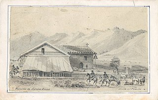
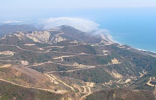
Rancho Santa Ana was a 21,522-acre (87.10 km2) Mexican land grant in present day Ventura County, California given in 1837 by Governor Juan Alvarado to Crisogono Ayala and Cosme Vanegas. Rancho Santa Ana was located inland in the Ventura River Valley on the west side of the Ventura River across from Rancho Ojai which was granted in the same year. Rancho Santa Ana encompassed present day Lake Casitas and Oak View.
Camp Bartlett is a small, isolated, rural unincorporated community in Upper Ojai, Ventura County, California, United States. Six of the twelve cabins in the community, located east of the city of Ojai, burned down in the Thomas Fire in 2017.
References
- ↑ Ogden Hoffman, 1862, Reports of Land Cases Determined in the United States District Court for the Northern District of California, Numa Hubert, San Francisco
- ↑ Diseño del Rancho Ojai
- ↑ United States. District Court (California: Southern District) Land Case 53 SD
- ↑ Fernando Tico profile, ojaivalleymuseum.org. Accessed November 12, 2022.
- ↑ United States. District Court (California: Southern District) Land Case 168 SD
- ↑ Finding Aid to the Documents Pertaining to the Adjudication of Private Land Claims in California, circa 1852-1892
- ↑ Report of the Surveyor General 1844-1886 Archived 2013-03-20 at the Wayback Machine
- ↑ Military Units in Southern California 1853-1862
- ↑ Mary Gray,1929,History of the Ojai Valley, The Star: An International Magazine, Vol II, No. 1, pp. 14-17, January 1929.
- ↑ Richard Hoye, Jane McClenahan, Tom Moore, 2007, Ojai, Arcadia Publishing; ISBN 978-0-7385-5577-5
- ↑ Hoover, Mildred B.; Rensch, Hero; Rensch, Ethel; Abeloe, William N. (1966). Historic Spots in California . Stanford University Press. ISBN 978-0-8047-4482-9.