Matilija Dam

Last updated

Matilija Dam
Matilija Dam Ventura Co Watershed Protection Dist.jpg
View of Matilija Dam from the air
CountryUnited States
Location Ojai, California
Coordinates 34°29′06″N119°18′30″W / 34.485007°N 119.308226°W / 34.485007; -119.308226
StatusCompletely silted
Construction began18 June 1946
Opening date1947 [1]
Construction cost≈$4M
Owner(s)Ventura County Watershed Protection District
Dam and spillways
Type of dam Concrete arch dam
Height198 ft (60 m) (original)
Length620 ft (190 m)
Reservoir
CreatesMatilija Reservoir
Total capacity7,018 acre⋅ft (8,657,000 m3) (original)
none (current)

Matilija Dam is a concrete arch dam in Ventura County, California, completed in 1947. Designed for water storage and flood control, it impounds Matilija Creek to create the Matilija Reservoir in the Los Padres National Forest, south of the Matilija Wilderness and north of Ojai. [2]

Contents

The drainage area above the damsite is 55 square miles (140 km2), and the reservoir had an original capacity of 7,018 acre⋅ft (8,657,000 m3). [1] Matilija Creek flows on to become the main tributary of the Ventura River.

Matilija was one of the Chumash rancherias under the jurisdiction of Mission San Buenaventura. According to Dartt-Newton and Erlandson writing in American Indian Quarterly, the name Chumash means "bead maker" or "seashell people" being that they originated near the Santa Barbara coast (Newton 416). [3] [4] [5]

History

In the 1940s, the Ventura County Flood Control District was formed to manage water resources along the Ventura River. A dam on Matilija Creek was proposed as part of a project to improve groundwater recharge around Ojai, where groundwater reserves had been exhausted by agricultural use and drought. In 1941 the U.S. Army Corps of Engineers warned that the dam would not be economically effective, as the steep, erosive topography upstream would cause it to silt up quickly. However, the project moved forward and in 1945 the county issued $682,000 in revenue bonds to fund it. Construction began on 18 June 1946 and was completed on 14 March 1948 at a cost of nearly $4 million, six times the original estimate. [1] [6]

The dam flooded an area that was used for recreation, including land belonging to the Matilija Hot Springs resort, and blocked access to spawning habitat for steelhead trout, as the dam was built without a fish ladder. Prior to the dam's construction, an estimated 5,000 steelhead spawned in the Ventura River each year; afterwards this dropped to a few hundred. In 1949, there was a major upstream fish kill caused by heated and/or stagnant water in the reservoir. [1] The reservoir filled for the first time in 1952, and in 1959 dam operations were transferred to the Casitas Municipal Water District. [1]

Modern officials describe the dam design as "flawed from the outset". [7] Many experts including the U.S. Army Corps of Engineers and the California Department of Fish and Game aligned themselves against the project, and before construction an architect advised that the proposed materials would react together badly. An engineering survey twenty years later proved him right, finding "internal swelling, external cracking, disintegration of the wall and movement of the abutments". [8]

Almost immediately after construction, the dam began silting up. [7] The dam traps about 30% of the total sediment in the Ventura River system, depriving ocean beaches of replenishing sediment. [6] Initially, engineers had estimated it would take 39 years for the reservoir to fill with silt, [1] but within a few years it was clear that the siltation rate was much faster than anticipated. In 1964 a safety study was commissioned from Bechtel Corporation, which determined the dam was unsafe and recommended removal. At the time, removal was projected to cost $300,000. The county decided to notch the dam face instead, reducing its effective height by 30 feet (9.1 m), leaving the dam in place while reducing water pressure on the structure. [1] In 1978 the dam was notched a second time. Taking into account the reservoir's reduced capacity and losses to sedimentation, the reservoir was projected to be completely silted up by the year 2020, and by 2021 it had been deemed completely filled with silt and gravel. [9]

Proposed removal

Ventura County officially set the course for removal of the dam as early as 1998. In October 2000 United States Secretary of the Interior Bruce Babbitt visited the site, operated a crane to remove a ceremonial concrete slab from the dam face, and brought national attention to the then-novel concept of dam removal. [10] The dam has been a candidate for removal since that time, along with the 1924 Rindge Dam near Malibu, completely silted up since 1950, and also blocking steelhead trout spawning grounds. [11]

The removal has been delayed by concerns over its potential impacts on flooding and the ecology of the Ventura River. The large amount of sediment trapped behind the dam, if released, could clog up the river channel and overwhelm the downstream Robles Diversion Dam, the primary source of water for Lake Casitas. [6] In 2004, the U.S. Army Corps of Engineers estimated that to remove all the sediment behind the dam would cost $200 million. Manually removing the sediment would be impractical, as it would require hundreds of thousands of truck trips, and there is no place to dump the sediment. [6] As an alternative, the Ventura County Watershed Protection District and the Army Corps developed a plan that would remove about one-fourth of the sediment before removing the dam, then stabilize part of the remaining sediment with soil cement. The stabilizing layers would be gradually removed over a period of several years, allowing natural high flows to flush the accumulated sediments downstream. [12] A bill funding the Matilija Dam Ecosystem Restoration Project reached Congress and survived President Bush's veto in November 2007, but the actual funding stalled. [13]

In 2011, activists painted a dotted line and a large pair of scissors on the face of the dam. The graffiti was seen as a commentary on the slow pace of the removal process, and was embraced by Ventura County, [7] appearing in the logo of the Matilija Dam Ecosystem Restoration Project. [14] The act was documented in the 2014 film DamNation .

In 2016 the Ventura County watershed Protection District and AECOM released a report which proposed several alternative options for removing the dam. [12]

In 2017, the California Department of Fish and Wildlife provided $3.3 million to fund the design phase for the selected alternative. The most recent proposal, projected to cost $111 million, will involve drilling a pair of 12-foot (3.7 m) diameter holes in the bottom of the Matilija Dam, as well as replacing two bridges on the Ventura River and upgrading the Robles diversion dam to handle increased sediment flows. [6] [15] The California Wildlife Conservation Board has provided two grants for the design phase. [16]

See also

Related Research Articles

<span class="mw-page-title-main">Santa Clara River (California)</span> River in Ventura and Los Angeles counties, California

The Santa Clara River is an 83 mi (134 km) long river in Ventura and Los Angeles counties in Southern California. It drains parts of four ranges in the Transverse Ranges System north and northwest of Los Angeles, then flows west onto the Oxnard Plain and into the Santa Barbara Channel of the Pacific Ocean.

<span class="mw-page-title-main">Elwha River</span> River in Washington, United States

The Elwha River is a 45-mile (72 km) river on the Olympic Peninsula in the U.S. state of Washington. From its source at Elwha snowfinger in the Olympic Mountains, it flows generally north to the Strait of Juan de Fuca. Most of the river's course is within the Olympic National Park.

<span class="mw-page-title-main">Santa Ynez River</span> River in California, United States

The Santa Ynez River is one of the largest rivers on the Central Coast of California. It is 92 miles (148 km) long, flowing from east to west through the Santa Ynez Valley, reaching the Pacific Ocean at Surf, near Vandenberg Space Force Base and the city of Lompoc.

<span class="mw-page-title-main">Rindge Dam</span> Dam in Malibu Creek State Park

Rindge Dam is a 100-foot-tall (30 m) dam on Malibu Creek in the Santa Monica Mountains of Southern California. Located in Malibu Creek State Park, it sits just northeast of Malibu Canyon Road, and is partially visible from the turnouts south of the tunnel. The dam, a major obstacle to river wildlife, is due to be removed with demolition work beginning in 2025 and finishing in 2035.

<span class="mw-page-title-main">Malibu Creek</span> River in the southern California

Malibu Creek is a year-round stream in western Los Angeles County, California. It drains the southern Conejo Valley and Simi Hills, flowing south through the Santa Monica Mountains, and enters Santa Monica Bay in Malibu. The Malibu Creek watershed drains 109 square miles (280 km2) and its tributary creeks reach as high as 3,000 feet (910 m) into Ventura County. The creek's mainstem begins south of Westlake Village at the confluence of Triunfo Creek and Lobo Canyon Creek, and flows 13.4 miles (21.6 km) to Malibu Lagoon.

<span class="mw-page-title-main">Carmel River (California)</span> River in Monterey County

The Carmel River is a 41 mi (66 km) river on the Central Coast of California in Monterey County that originates in the Ventana Wilderness of the Santa Lucia Mountains. The river flows northwest through Carmel Valley with its mouth at the Pacific Ocean south of Carmel-by-the-Sea, at Carmel Bay. The Carmel River is considered the northern boundary of Big Sur, the other boundaries being San Carpóforo Creek and the Pacific coastline.

<span class="mw-page-title-main">Sisquoc River</span> River in California, United States

The Sisquoc River is a westward flowing river in northeastern Santa Barbara County, California. It is a tributary of the Santa Maria River, which is formed when the Sisquoc River meets the Cuyama River at the Santa Barbara County and San Luis Obispo County border just north of Garey. The river is 57.4 miles (92.4 km) long and originates on the north slopes of Big Pine Mountain, at approximately 6,320 feet (1,930 m). Big Pine Mountain is part of the San Rafael Mountains, which are part of the Transverse Ranges.

<span class="mw-page-title-main">Ventura River</span> River in western Ventura County in southern California, United States

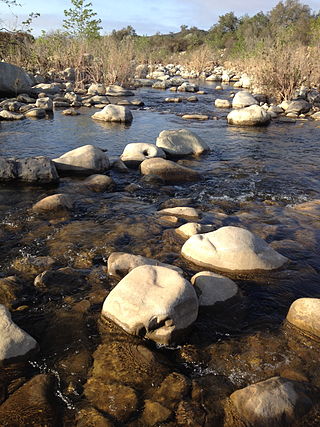
The Ventura River, in western Ventura County in southern California, United States, flows 16.2 miles (26.1 km) from its headwaters to the Pacific Ocean. The smallest of the three major rivers in Ventura County, it flows through the steeply sloped, narrow Ventura Valley, with its final 0.7 miles (1.1 km) through the broader Ventura River estuary, which extends from where it crosses under a 101 Freeway bridge through to the Pacific Ocean.

<span class="mw-page-title-main">Alameda Creek</span> River in California, United States

Alameda Creek is a large perennial stream in the San Francisco Bay Area. The creek runs for 45 miles (72 km) from a lake northeast of Packard Ridge to the eastern shore of San Francisco Bay by way of Niles Canyon and a flood control channel. Along its course, Alameda Creek provides wildlife habitat, water supply, a conduit for flood waters, opportunities for recreation, and a host of aesthetic and environmental values. The creek and three major reservoirs in the watershed are used as water supply by the San Francisco Public Utilities Commission, Alameda County Water District and Zone 7 Water Agency. Within the watershed can be found some of the highest peaks and tallest waterfall in the East Bay, over a dozen regional parks, and notable natural landmarks such as the cascades at Little Yosemite and the wildflower-strewn grasslands and oak savannahs of the Sunol Regional Wilderness. After an absence of half a century, ocean-run steelhead trout are able to return to Alameda Creek to mingle with remnant rainbow trout populations. Completion of a series of dam removal and fish passage projects, along with improved stream flows for cold-water fish and planned habitat restoration, enable steelhead trout and Chinook salmon to access up to 20 miles (32 km) of spawning and rearing habitat in Alameda Creek and its tributaries. The first juvenile trout migrating downstream from the upper watershed through lower Alameda Creek toward San Francisco Bay was detected and documented in April 2023.

<span class="mw-page-title-main">Condit Hydroelectric Project</span> Former dam in Washington, United States

Condit Hydroelectric Project was a development on the White Salmon River in the U.S. state of Washington. It was completed in 1913 to provide electrical power for local industry, and is listed in the National Register of Historic Places as an engineering and architecture landmark.

<span class="mw-page-title-main">Elwha Dam</span> Dam in Washington, USA

The Elwha Dam was a 108-ft high dam located in the United States, in the state of Washington, on the Elwha River approximately 4.9 miles (7.9 km) upstream from the mouth of the river on the Strait of Juan de Fuca.

<span class="mw-page-title-main">San Francisquito Creek</span> River in California, United States

San Francisquito Creek is a creek that flows into southwest San Francisco Bay in California, United States. Historically it was called the Arroyo de San Francisco by Juan Bautista de Anza in 1776. San Francisquito Creek courses through the towns of Portola Valley and Woodside, as well as the cities of Menlo Park, Palo Alto, and East Palo Alto. The creek and its Los Trancos Creek tributary define the boundary between San Mateo and Santa Clara counties.

<span class="mw-page-title-main">Matilija Creek</span> River in California, United States of America

Matilija Creek is a major stream in Ventura County in the U.S. state of California. It joins with North Fork Matilija Creek to form the Ventura River. Many tributaries feed the mostly free flowing, 17.3-mile (27.8 km) creek, which is largely contained in the Matilija Wilderness. Matilija was one of the Chumash rancherias under the jurisdiction of Mission San Buenaventura. The meaning of the Chumash name is unknown.

<span class="mw-page-title-main">Dam removal</span>

Dam removal is the process of demolishing a dam, returning water flow to the river. Arguments for dam removal consider whether their negative effects outweigh their benefits. The benefits of dams include hydropower production, flood control, irrigation, and navigation. Negative effects of dams include environmental degradation, such as reduced primary productivity, loss of biodiversity, and declines in native species; some negative effects worsen as dams age, like structural weakness, reduced safety, sediment accumulation, and high maintenance expense. The rate of dam removals in the United States has increased over time, in part driven by dam age. As of 1996, 5,000 large dams around the world were more than 50 years old. In 2020, 85% percent of dams in the United States are more than 50 years old. In the United States roughly 900 dams were removed between 1990 and 2015, and by 2015, the rate was 50 to 60 per year. France and Canada have also completed significant removal projects. Japan's first removal, of the Arase Dam on the Kuma River, began in 2012 and was completed in 2017. A number of major dam removal projects have been motivated by environmental goals, particularly restoration of river habitat, native fish, and unique geomorphological features. For example, fish restoration motivated the Elwha Ecosystem Restoration and the dam removal on the river Allier, while recovery of both native fish and of travertine deposition motivated the restoration of Fossil Creek.

<span class="mw-page-title-main">Restoration of the Elwha River</span> Dam removal and ecosystem restoration project in Washington, United States

The Elwha Ecosystem Restoration Project is a 21st-century project of the U.S. National Park Service to remove two dams on the Elwha River on the Olympic Peninsula in Washington state, and restore the river to a natural state. It is the largest dam removal project in history and the second largest ecosystem restoration project in the history of the National Park Service, after the Restoration of the Everglades. The controversial project, costing about $351.4 million, has been contested and periodically blocked for decades. It has been supported by a major collaboration among the Lower Elwha Klallam Tribe, and federal and state agencies.

<span class="mw-page-title-main">Searsville Dam</span> Dam in California, USA

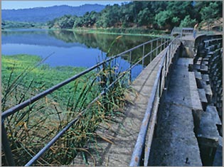
Searsville Dam is a masonry dam in San Mateo County, California that was completed in 1892, one year after the founding of Stanford University, and impounds Corte Madera Creek to form a reservoir known as Searsville Reservoir or Searsville Lake. Searsville Dam is located in the Jasper Ridge Biological Preserve and is owned and operated by Stanford University. Neighboring cities include Woodside and Portola Valley, California.

<span class="mw-page-title-main">Gibraltar Dam</span> Dam in Santa Barbara County, California

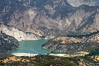
Gibraltar Dam is located on the Santa Ynez River, in southeastern Santa Barbara County, California, in the United States. Forming Gibraltar Reservoir, the dam is owned by the city of Santa Barbara. Originally constructed in 1920 and expanded in 1948, the dam and reservoir are located in a remote part of the Los Padres National Forest.

<span class="mw-page-title-main">Salt River (California)</span> River in California, United States

The Salt River is a formerly navigable hanging channel of the Eel River which flowed about 9 miles (14 km) from near Fortuna and Waddington, California, to the estuary at the Pacific Ocean, until siltation from logging and agricultural practices essentially closed the channel. It was historically an important navigation route until the early 20th century. It now intercepts and drains tributaries from the Wildcat Hills along the south side of the Eel River floodplain. Efforts to restore the river began in 1987, permits and construction began in 2012, and water first flowed in the restored channel in October 2013.

<span class="mw-page-title-main">Guadalupe Creek (Santa Clara County)</span> Stream in Santa Clara County, California

Guadalupe Creek is a 10.5 miles (16.9 km) northward-flowing stream originating just east of the peak of Mount Umunhum in Santa Clara County, California, United States. It courses along the northwestern border of Almaden Quicksilver County Park in the Cañada de los Capitancillos before joining Los Alamitos Creek after the latter exits Lake Almaden. This confluence forms the Guadalupe River mainstem, which in turn flows through San Jose and empties into south San Francisco Bay at Alviso Slough.

The Matilija Wilderness is a 29,207-acre (11,820 ha) wilderness area in Ventura and Santa Barbara Counties, Southern California. It is managed by the U.S. Forest Service, being situated within the Ojai Ranger District of the Los Padres National Forest. It is located adjacent to the Dick Smith Wilderness to the northwest and the Sespe Wilderness to the northeast, although it is much smaller than either one. The Matilija Wilderness was established in 1992 in part to protect California condor habitat.

References

  1. 1 2 3 4 5 6 7 "Matilija Dam Facts and History". Matilija Dam Ecosystem Restoration Project. Retrieved 11 April 2016.
  2. Miller, Joanna M. (20 March 1994). "A Few Deadly Floods Stand Out in County". Los Angeles Times . Retrieved 19 March 2017.
  3. Dartt-Newton, Deana & Erlandson, Jon (Summer/Fall 2006). "Little Choice for the Chumash: Colonialism, Cattle, and Coercion in Mission Period California". American Indian Quarterly , Vol. 30, No. 3 & 4, 416
  4. Erwin G. Gudde, William Bright (2004). California Place Names: The Origin and Etymology of Current Geographical Names. University of California Press. p. 231. ISBN   978-0-520-24217-3 . Retrieved 29 January 2011.
  5. Durham, David L. (1998). California's Geographic Names: A Gazetteer of Historic and Modern Names of the State. Quill Driver Books. ISBN   978-1-884995-14-9.
  6. 1 2 3 4 5 Jacobs, Jeremy P. (23 August 2017). "How a useless dam nearly destroyed an iconic beach". E&E News. Retrieved 23 August 2020.
  7. 1 2 3 Chawkens, Steve (19 September 2011). "On a divisive barrier, a snippy bit of graffiti". Los Angeles Times. Retrieved 11 April 2016.
  8. Stolz, Kit (15 April 2001). "It's Time to End the Sad Saga of Silt-Clogged Matilija Dam". Los Angeles Times. Retrieved 11 April 2016.
  9. Atlas Obscura (2021). "Matilija Dam - Ojai, California" . Retrieved 21 June 2021.
  10. Booth, William (21 January 2001). "Dam-removal Sentiment Flows More Freely Now". Washington Post (syndicated). Retrieved 11 April 2016.
  11. Aryeh, Olivia (17 December 2008). "Corps gives update on Rindge Dam removal study". Malibu Times. Retrieved 9 December 2018.
  12. 1 2 AECOM (March 2016). "Dam Removal Concepts Evaluation Report" (PDF). Stillwater Services. Retrieved 21 June 2021.
  13. Carlson, Cheri (3 March 2013). "Delayed plan to remove Matilija Dam near Ojai will get new studies". Ventura County Star. Retrieved 11 April 2016.
  14. "Home". Matilija Dam Ecosystem Restoration Project. Ventura County Public Works. 7 May 2019. Retrieved 14 August 2023.
  15. California Department of Fish and Wildlife (11 February 2020). "Matilija Dam Ecosystem Restoration Project". ArcGIS.
  16. Carlson, Cheri (23 February 2023). "Efforts to remove Matilija Dam get $4.3 million to clear one hurdle, more ahead". Ventura County Star. Retrieved 25 February 2023.

Matilija Dam webcam