
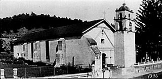
Mission San Buenaventura, formally known as the Mission Basilica of San Buenaventura, is a Catholic parish and basilica in the Archdiocese of Los Angeles. The parish church in the city of Ventura, California, United States, is a Spanish mission founded by the Order of Friars Minor. Founded on March 31, 1782, it was the ninth Spanish mission established in Alta California and the last to be established by the head of the Franciscan missions in California, Junípero Serra. Designated a California Historical Landmark, the mission is one of many locally designated landmarks in downtown Ventura.

Ventura, officially named San Buenaventura, is a city in and the county seat of Ventura County, California, United States. It is a coastal city located northwest of Los Angeles. The population was 110,763 at the 2020 census. Ventura is a popular tourist destination, owing to its historic landmarks, beaches, and resorts.

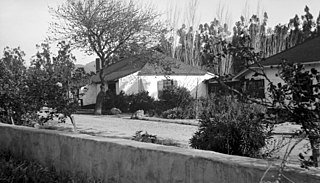
Chatsworth is a suburban neighborhood in Los Angeles, California, in the San Fernando Valley.

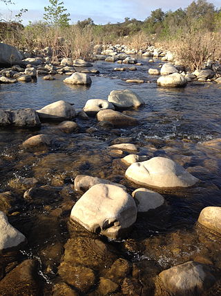
The Santa Clara River is an 83 mi (134 km) long river in Ventura and Los Angeles counties in Southern California. It drains parts of four ranges in the Transverse Ranges System north and northwest of Los Angeles, then flows west onto the Oxnard Plain and into the Santa Barbara Channel of the Pacific Ocean.

A California Historical Landmark (CHL) is a building, structure, site, or place in the U.S. state of California that has been determined to have statewide historical landmark significance.

The Ventura County Courthouse, known since 1974 as Ventura City Hall, is a historic building in Ventura, California. Located on a hill at the top of California Street, it overlooks the city's downtown district with views of the Santa Barbara Channel and Channel Islands. It was the first building in the City of Ventura to be listed on the National Register of Historic Places and has also received historic designations at the state, county and city levels.
Rancho Camulos, now known as Rancho Camulos Museum, is a ranch located in the Santa Clara River Valley 2.2 miles (3.5 km) east of Piru, California and just north of the Santa Clara River, in Ventura County, California. It was the home of Ygnacio del Valle, a Californio alcalde of the Pueblo de Los Angeles in the 19th century and later elected member of the California State Assembly. The ranch was known as the Home of Ramona because it was widely believed to have been the setting of the popular 1884 novel Ramona by Helen Hunt Jackson. The novel helped to raise awareness about the Californio lifestyle and romanticized "the mission and rancho era of California history."
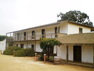
The Olivas Adobe in Ventura, California is an adobe structure built in 1837 by Raymundo Olivas on the north bank of the Santa Clara River about a mile from the estuary where it flows into the Santa Barbara Channel.
The Ventura River, in western Ventura County in southern California, United States, flows 16.2 miles (26.1 km) from its headwaters to the Pacific Ocean. The smallest of the three major rivers in Ventura County, it flows through the steeply sloped, narrow Ventura Valley, with its final 0.7 miles (1.1 km) through the broader Ventura River estuary, which extends from where it crosses under a 101 Freeway bridge through to the Pacific Ocean.

Wagon Wheel is a densely populated, planned neighborhood of Oxnard, California at the intersection of U.S. Route 101 and Oxnard Boulevard. The neighborhood was originally developed as an office, motel, and restaurant complex named Wagon Wheel Junction with a convenient roadside location near the historic community of El Rio. The site in Ventura County became a popular stop for travelers between Los Angeles and Santa Barbara, particularly during its heyday in the 1950s, 1960s and 1970s. The entire site was demolished in 2011 to begin the development of the community with 1,500 residential units. The Esplanade Shopping Center is directly across Oxnard Boulevard with The Collection at RiverPark shopping center located farther along Oxnard Boulevard on the other side of the 101 freeway.
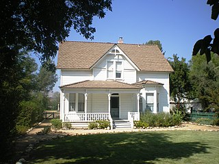
The historic Simi Adobe–Strathearn House served as the headquarters of Rancho Simi, also known as Rancho San José de Nuestra Senora de Altagracia y Simi, one of the land grants in Alta California by the Spanish government. The name derives from Shimiji, the name of the Chumash village here before the Spanish. Rancho Simi was the earliest Spanish colonial land grant within Ventura and Santa Barbara Counties. At 113,000 acres, Rancho Simi was one of the state's largest land grants.
The San Buenaventura Conservancy for Preservation is an historic preservation organization in Ventura, California also known by its early name of San Buenaventura. It works to recognize and revitalize historic, archeological and cultural resources in the region. The Conservancy is a non-profit 501c3 organization. The group was formed in 2004 after the demolition of the Mayfair Theater, an S. Charles Lee, Streamline Moderne, movie theater in downtown Ventura, California that was razed and replaced with a condominium project.
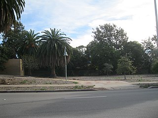
The San Miguel Chapel Site is an archeological site in Ventura, California, United States, at the location of the first outpost and center of operations that was established while the first Mission San Buenaventura was being constructed. The San Miguel Chapel was located just outside the southwest corner of the walled garden that was constructed as part of the ultimate layout of the mission complex. The open space park is located at the southwest corner of Thompson Boulevard and Palm Street in downtown Ventura. Interpretative signs and public art have been added to the site, which is protected and managed as a natural environment by the city parks department.
The City of Ventura Historic Landmarks and Districts consist of buildings, sites, and neighborhoods designated by the City of Ventura, California, as historic landmarks and districts.

Ortega Adobe is a historic adobe house built in 1857 and located on Main Street on the west side of Ventura, California, not far from the mouth of the Ventura River. It was designated in 1974 as the City of Ventura's Historic Landmark No. 2. It is owned by the City and operated as a self-guided historical site.
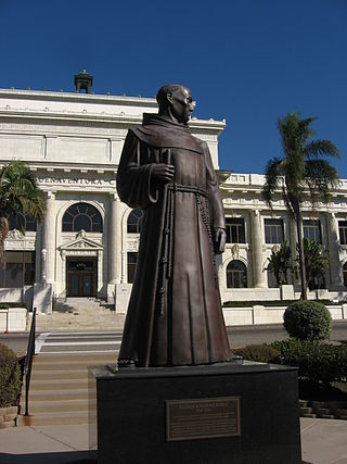
The Father Serra statue at the Mission San Buenaventura in Ventura, California, representing Junípero Serra, the founder of the mission, was commissioned by Ventura County through the Works Progress Administration as part of the Federal Art Project in 1935. This statue, made of concrete from a clay model by Uno John Palo Kangas, was originally placed in 1936 in a prominent location in a public park across the street from the Ventura County Courthouse. After the Courthouse was repurposed as Ventura City Hall, the statue was designated as City of Ventura Historic Landmark No. 3 in 1974. As deterioration of the concrete statue became a concern, a wood replica was created by local carvers and used to make a bronze cast. The concrete statue was replaced by the bronze cast in 1989. The wood replica was set in the atrium of the city hall for public display.

The Serra Cross, sometimes also known as the Cross on the Hill or the Grant Park Cross, is a Christian cross on a hill known as "La Loma de la Cruz" in Ventura, California. The site is in Serra Cross Park, a one-acre parcel within the larger Grant Park that overlooks downtown Ventura, the Santa Barbara Channel, and Anacapa and Santa Cruz Islands.

The Peirano Market, also known as Peirano's Grocery and Peirano Store, is a historic building in Ventura, California. Located across the street from the Mission San Buenaventura, the red brick structure was built in 1877 and has ornamental relief brickwork and a mansard, Spanish revival tile roof.
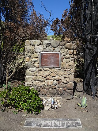
The Santa Gertrudis Asistencia, also known as the Santa Gertrudis Chapel, was an asistencia ("sub-mission") to the Mission San Buenaventura, part of the system of Spanish missions in Las Californias—Alta California. Built at an unknown date between 1792 and 1809, it was located approximately five miles from the main mission, inland and upstream along the Ventura River. The site was buried in 1968 by the construction of California State Route 33. Prior to the freeway's construction, archaeologists excavated and studied the site. A number of foundation stones were moved and used to create the Santa Gertrudis Asistencia Monument which was designated in 1970 as Ventura County Historic Landmark No. 11.


