Russian Gulch State Park

Last updated
Russian Gulch State Park
Russian Gulch Beach.jpg
The beach at Russian Gulch State Park, and the Frederick W. Panhorst Bridge above it
Relief map of California.png
Red pog.svg
Usa edcp relief location map.png
Red pog.svg
Location Mendocino County, California, USA
Nearest city Mendocino, California
Coordinates 39°20′N123°47′W / 39.333°N 123.783°W / 39.333; -123.783 Coordinates: 39°20′N123°47′W / 39.333°N 123.783°W / 39.333; -123.783
Governing body California Department of Parks and Recreation

Russian Gulch State Park is a California State Park in coastal Mendocino County, California, two miles north of Mendocino and seven miles south of Fort Bragg.

California U.S. state in the United States

California is a state in the Pacific Region of the United States. With 39.6 million residents across a total area of about 163,696 square miles (423,970 km2), California is the most populous U.S. state and the third-largest by area. The state capital is Sacramento. The Greater Los Angeles Area and the San Francisco Bay Area are the nation's second- and fifth-most populous urban regions, with 18.7 million and 9.7 million residents respectively. Los Angeles is California's most populous city, and the country's second-most populous, after New York City. California also has the nation's most populous county, Los Angeles County, and its largest county by area, San Bernardino County. The City and County of San Francisco is both the country's second-most densely populated major city after New York City and the fifth-most densely populated county, behind only four of the five New York City boroughs.

Mendocino, California Unincorporated area in California, United States

Mendocino is an unincorporated community in Mendocino County, California, United States. Mendocino is located 9.5 miles (15 km) south of Fort Bragg, at an elevation of 154 feet. The population of the census-designated place (CDP) was 894 at the 2010 census, up from 824 at the 2000 census. The town's name comes from Cape Mendocino, named by early Spanish navigators in honor of Antonio de Mendoza, Viceroy of New Spain. In turn, the etymology of Mendoza is "cold mountain."

Fort Bragg, California City in California, United States

Fort Bragg is a coastal city along California's Shoreline Highway in Mendocino County. It is 24 mi (39 km) west of Willits, at an elevation of 85 feet. A California Historical Landmark, the city was founded, prior to the American Civil War, as a military garrison rather than a fortification. Fort Bragg is a tourist destination because of its picturesque views of the Pacific Ocean. Its population was 7,273 at the 2010 census.

Contents

Park features

The park features 7630 feet of rocky ocean shores; [1] it is approximately 3/4 of a mile wide from north to south at its widest point, and extends for approximately three miles from east to west. [2] Russian Gulch is crossed by California State Highway 1, which passes over the gulch on the Frederick W. Panhorst Bridge, a large concrete arch bridge constructed in 1940. [3] The park entrance is on the west side of Highway 1, north of the bridge, and connects by a one-lane road under the bridge to the eastern part of the park. The smaller, western portion of the park consists largely of headlands with a blowhole and picnic areas, while the larger eastern portion of the park includes a campground, the park headquarters, and several trails for bicycles, hikers, and horses. [4] A 2.5 mile hike from the trailhead at the east end of the campground to a 36-foot waterfall largely follows an abandoned logging road along the creek. [4] [5] A small beach, physically in the western part of the park but accessed by a road from the eastern side, is equipped with a restroom and an outdoor shower; [4] swimming, skin diving, fishing, and tide pool exploration are all possible. [1]

Frederick W. Panhorst Bridge

The Frederick W. Panhorst Bridge, more commonly known as the Russian Gulch Bridge, is a reinforced concrete open-spandrel deck arch bridge on California State Highway 1, spanning Russian Gulch Creek in Russian Gulch State Park, Mendocino County, California, United States. It is named after Frederick W. Panhorst, who served as the Chief of the Bridge Section of the California Division of Highways from 1931 to 1960.

Concrete Composite construction material

Concrete, usually Portland cement concrete, is a composite material composed of fine and coarse aggregate bonded together with a fluid cement that hardens over time—most frequently in the past a lime-based cement binder, such as lime putty, but sometimes with other hydraulic cements, such as a calcium aluminate cement or Portland cement. It is distinguished from other, non-cementitious types of concrete all binding some form of aggregate together, including asphalt concrete with a bitumen binder, which is frequently used for road surfaces, and polymer concretes that use polymers as a binder.

Arch bridge bridge type characterized by its supporting arches

An arch bridge is a bridge with abutments at each end shaped as a curved arch. Arch bridges work by transferring the weight of the bridge and its loads partially into a horizontal thrust restrained by the abutments at either side. A viaduct may be made from a series of arches, although other more economical structures are typically used today.

History

The name "Russian Gulch" was given to the area by U.S. government surveyors, in honor of the Russian fur trappers who founded Fort Ross fifty miles to the south; [1] according to a more specific local tradition, a deserter from Fort Ross lived at Russian Gulch. [2] [6] In the second half of the 19th century, schooners would frequently make dangerous stops in the cove to take on coast redwood lumber and passengers; the headlands still contain iron rings used to hold ropes and move lumber when these ships docked, and a mill made redwood shingles on what is now the site of a park recreation hall. [1] Some of the land within what is now the park was farmed in the late 19th century, and in the mid-1920s a property developer from Los Angeles, F. O. Warner, bought land in the area with the intention of building a resort there. [2] The Native Sons of the Golden West began a drive to turn the area into a park in 1928, [2] and after funds were provided by A. Johnston, the county, and the state, the park was founded in 1933. [1]

Schooner Sailing vessel

A schooner is a type of sailing ship, as defined by its rig configuration. Typically it has two or more masts, the foremast being slightly shorter than the mainmast.

<i>Sequoia sempervirens</i> species of plant of the monotypic genus Sequoia in the cypress family (Cupressaceae)

Sequoia sempervirens is the sole living species of the genus Sequoia in the cypress family Cupressaceae. Common names include coast redwood, coastal redwood and California redwood. It is an evergreen, long-lived, monoecious tree living 1,200–1,800 years or more. This species includes the tallest living trees on Earth, reaching up to 379 feet (115.5 m) in height and up to 29.2 feet (8.9 m) in diameter at breast height (dbh). These trees are also among the oldest living things on Earth. Before commercial logging and clearing began by the 1850s, this massive tree occurred naturally in an estimated 2,100,000 acres (850,000 ha) along much of coastal California and the southwestern corner of coastal Oregon within the United States.

Native Sons of the Golden West

The Native Sons of the Golden West is a fraternal service organization founded in 1875, limited to native born Californians and dedicated to historic preservation, documentation of historic structures and places in the state, the placement of historic plaques and other charitable functions within California. In 1890 they placed the first historical marker in the state to honor the discovery of gold which gave rise to the state nickname "Golden State" and "Golden West." Former U.S. President Richard M. Nixon and former Chief Justice of the United States Earl Warren were both past presidents of the NSGW.

Russian Gulch was one of 70 state parks due for closure in 2012 due to state budget cuts. [7]

See also

Related Research Articles

Mendocino County, California County in California, United States

Mendocino County is a county located on the north coast of the U.S. state of California. As of the 2010 census, the population was 87,841. The county seat is Ukiah.

Oregon Coast Trail

The Oregon Coast Trail (OCT) is a long-distance hiking route along the Pacific coast of the U.S. state of Oregon in the United States. It follows the coast of Oregon from the mouth of the Columbia River to the California border south of Brookings.

Elk, Mendocino County, California Unincorporated community in California, United States

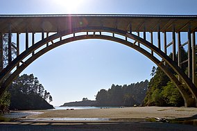
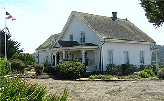
Elk is an unincorporated community in Mendocino County, California. It is located 22 miles (35 km) south of Fort Bragg, at an elevation of 135 feet.

Mendocino Woodlands State Park United States historic place

The Mendocino Woodlands State Park is a group camping facility located at 39350 Little Lake Road, Mendocino County, California, seven miles (11 km) inland from the town of Mendocino. It was built as a Recreational Demonstration Area by the Civilian Conservation Corps. Mendocino Woodlands consists of approximately 700 acres (2.8 km2) of land along the Little North Fork of the Big River and is surrounded to the north, east, and west by the 50,000-acre (200 km²) Jackson Demonstration State Forest. To the south, the park abuts the Big River State Park. It was declared a National Historic Landmark on September 25, 1997.

Navarro River Redwoods State Park

Navarro River Redwoods State Park is a state park in Mendocino County, California, consisting of 660 acres (2.7 km2) of second-growth redwood forest in a narrow stretch 11 miles (18 km) long on both banks of the Navarro River, from the town of Navarro to the river's confluence with the Pacific Ocean.

Hendy Woods State Park

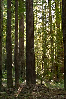
Hendy Woods State Park is a state park of California, USA, located in the Anderson Valley of Mendocino County. It is known for its old-growth coast redwoods and also provides camping facilities near the wineries of the Anderson Valley. It is named after Joshua Hendy, who owned the land and stipulated that it be protected; it passed through several owners after Hendy without being logged, before becoming part of the California State Park system in 1958.

Smith River National Recreation Area

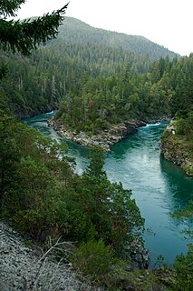
Smith River National Recreation Area is located northwestern California, United States. The Smith River National Recreation Area is in Six Rivers National Forest and is managed by the U.S. Forest Service, an agency of the U.S. Department of Agriculture. Created by Congress in 1990, Smith River National Recreation Area forms a northern border to Redwood National and State Parks.

North Coast (California) Place in California, United States

The North Coast of California is the region in Northern California that lies on the Pacific coast between San Francisco Bay and the Oregon border. It commonly includes Mendocino, Humboldt, and Del Norte counties and sometimes includes two counties from the San Francisco Bay area, Marin and Sonoma.

Mendocino Headlands State Park park in Mendocino, California

Mendocino Headlands State Park is a California State Park in Mendocino, California. It consists of 347 acres (1.4 km2) of undeveloped seaside bluffs and islets surrounding the town of Mendocino, two beaches, and the much larger Big River Unit stretching for eight miles (13 km) along both banks of the nearby Big River.

MacKerricher State Park

MacKerricher State Park is a state park in California in the United States. It is located three miles north of Fort Bragg in Mendocino County. It covers nine miles of coastline and contains several types of coastal habitat, including beaches, dunes, headlands, coves, wetlands, tide pools, forest, and a freshwater lake.

Bolinas Ridge mountain in United States of America

Bolinas Ridge is a north-south ridge in southwestern Marin County, California. Much of the western side of the ridge is protected parkland in the Golden Gate National Recreation Area, and the eastern side is watershed lands of the Marin Municipal Water District.

Caspar Headlands State Beach

Caspar Headlands State Beach is a protected beach in the state park system of California, USA. It is located in Northern California in Mendocino County near the village of Caspar. The 75-acre (30 ha) park was established in 1972.

Greenwood State Beach

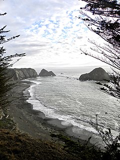
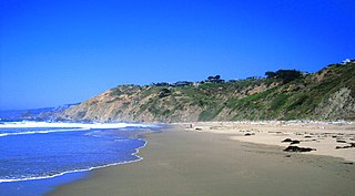
Greenwood State Beach, also known as Elk Beach, is a state-protected beach of California, USA. It is located in the unincorporated village of Elk in Mendocino County. It is located about 15 miles (24 km) north of Point Arena on Highway 1. The 47-acre (19 ha) park was established in 1978.

Schooner Gulch State Beach

Schooner Gulch State Beach is a beach located in Mendocino County, California. It is located approximately 50 miles northwest of Santa Rosa. It offers a scenic spot along the Mendocino coast and a stunning perch for watching sunsets. Visitors to the beach come to surf, fish, and picnic. Hiking is also a very popular activity to do at this beach, as there are a few trails that will take you up and down the coast.

Usal Creek river in the United States of America

Usal Creek is the southernmost drainage basin unbridged by California State Route 1 on California's Lost Coast. The unpaved county road following the westernmost ridge line south from the King Range crosses Usal Creek near the Pacific coast, but the bridge may be removed during winter months. Usal Creek, 9.7 miles (15.6 km) long, drains about 28 square miles (73 km2) on the Mendocino Coast and empties into the Pacific Ocean near the former company town of Usal.

Bowling Ball Beach Part of Schooner Gluch State Beach in Mendocino County, California

Bowling Ball Beach is a part of Schooner Gulch State Beach, in Mendocino County, California, in the United States. It is named for the spherical sandstone concretions found there at low tide.

Mendocino Lumber Company operated a sawmill on Big River near the town of Mendocino, California. The sawmill began operation in 1853 as the Redwood Lumber Manufacturing Company, and changed ownership several times before cutting its final logs in 1938. The sawmill site became part of the Big River Unit of Mendocino Headlands State Park where a few features of the mill and its associated forest railway are still visible along the longest undeveloped estuary in northern California.

References

  1. 1 2 3 4 5 Russian Gulch SP, California State Park System.
  2. 1 2 3 4 Russian Gulch State Park brochure (PDF), California State Park System, 2003, Archived from the original on June 9, 2004CS1 maint: unfit url (link).
  3. Russian Gulch Bridge, California State Park System.
  4. 1 2 3 Ostertag, George (2001), California State Parks: A Complete Recreation Guide, The Mountaineers Books, pp. 42–44, ISBN   978-0-89886-762-6 .
  5. Freeze, Dennis F. (2002), Mendocino Outdoors, Monolith Press, pp. 26–27, ISBN   0-9722769-0-4 .
  6. Stewart, George R. (1950), "Three Mendocino names", Western Folklore, Western States Folklore Society, 9 (2): 154–155, doi:10.2307/1496550, JSTOR   1496550 .
  7. Brennan, Pat (May 13, 2011), "State cuts force closure of 70 parks", Orange County Register .