
Monterey County, officially the County of Monterey, is a county located on the Pacific coast in the U.S. state of California. As of the 2020 census, its population was 439,035. The county's largest city and county seat is Salinas.

Cannery Row is the waterfront street bordering the city of Pacific Grove, but officially in the New Monterey section of Monterey, California. It was the site of a number of now-defunct sardine canning factories. The last cannery closed in 1973. The street name, formerly a nickname for Ocean View Avenue, became official in January 1958 to honor John Steinbeck and his well-known novel Cannery Row. In the novel's opening sentence, Steinbeck described the street as "a poem, a stink, a grating noise, a quality of light, a tone, a habit, a nostalgia, a dream."

Marina is a city in Monterey County, California, United States. The United States Census Bureau estimated its 2019 population at 22,781. Marina is located along the central coast of California, 8 miles (13 km) west of Salinas, and 8 miles (13 km) north of Monterey. Marina is on California State Route 1 between Monterey and Santa Cruz. Marina is at an elevation of 43 feet. Marina was incorporated in 1975 and is the newest city on the Monterey Peninsula. The city includes part of the California State University, Monterey Bay campus, UC Santa Cruz UC MBEST center, and the Veterans Transition Center (VTC). In 2012, Marina was named one of the 100 Best Communities for Young People by America's Promise Alliance. The Fort Ord Station Veterinary Hospital, built in 1941 to provide healthcare for U.S. Army horses and mules, was listed on the National Register of Historic Places in 2014.

Sand City is a city in Monterey County, California, United States, located on the shores of Monterey Bay, and surrounded on most sides by the larger city of Seaside. Sand City is located 2 miles (3.2 km) northeast of Monterey, at an elevation of 72 feet. The population was 334 at the 2010 census, up from 261 at the 2000 census. The city is predominantly a business community, and has a number of larger retail stores. The West End area of Sand City, once an industrial area, hosts a growing artists' colony. Every August, the artists of Sand City and neighboring areas hold a street fair called the "West End Celebration".

Seaside, formerly East Monterey, is a city in Monterey County, California, United States, with a population of 32,366 as of the 2020 census. Seaside is located 2.25 miles (3.6 km) east-northeast of Monterey, at an elevation of 33 feet (10 m), and is the home of California State University, Monterey Bay (CSUMB) and the Monterey College of Law, which are located on the site of the former military base Fort Ord. Also on the site are the Bayonet and Black Horse golf courses, now open to the public and host to PGA Tour events, including the 2012 PGA Professional National Championship. Seaside is also the gateway to the Fort Ord National Monument Park, created on April 20, 2012.

Seaside is a city in Clatsop County, Oregon, United States, on the coast of the Pacific Ocean. The name Seaside is derived from Seaside House, a historic summer resort built in the 1870s by railroad magnate Ben Holladay. The city's population was 6,457 at the 2010 census.

The Central Coast is an area of California, roughly spanning the coastal region between Point Mugu and Monterey Bay. It lies northwest of Los Angeles County and south of San Mateo and Santa Clara counties, and includes the rugged, undeveloped stretch of coastline known as Big Sur. From south to north, there are six counties that make up the Central Coast: Ventura, Santa Barbara, San Luis Obispo, Monterey, San Benito, and Santa Cruz.

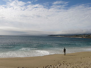
Asilomar State Beach, officially Asilomar State Beach and Conference Grounds State Park, is a state park unit of California, United States. It provides public access to rocky coast and dune habitat on the Monterey Peninsula. The property includes the Asilomar Conference Grounds, a conference center built by the YWCA in 1913 that is now a National Historic Landmark. The 107-acre (43 ha) site is located in Pacific Grove and offers overnight lodging and views of the forest, surf and sand.

Zmudowski State Beach is located on Monterey Bay, in Moss Landing, Monterey County, northern California.

The Santa Cruz Beach Boardwalk is an oceanfront amusement park in Santa Cruz, California. Founded in 1907, it is California's oldest surviving amusement park and one of the few seaside parks on the West Coast of the United States.
Carmel River State Beach is a state park unit at the mouth of Carmel Valley, California, United States, featuring a 1-mile-long (1.6 km) protected beach with a lagoon formed by the Carmel River. The lagoon attracts many migratory birds. The state beach includes Monastery Beach, which is popular with scuba divers. Sea kayakers also frequent the beach, which has easy access to the natural reserves of Point Lobos. The 297-acre (120 ha) park was established in 1953.

Marina State Beach is a protected beach on Monterey Bay, located in the city of Marina in Monterey County, California.

Garrapata State Park is a state park of California, United States, located on California State Route 1 6.7 miles (10.8 km) south of Carmel and 18 miles (29 km) north of Big Sur Village on the Monterey coast. The 2,939-acre (1,189 ha) park was established in 1979. California sea lions, harbor seals and sea otters frequent the coastal waters while gray whales pass close by during their yearly migration.
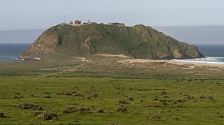
Point Sur State Historic Park is a California State Park on the Big Sur coastline of Monterey County, California, United States, 19 miles (31 km) south of Rio Road in Carmel. The 1889 Point Sur Lighthouse is on the National Register of Historic Places.
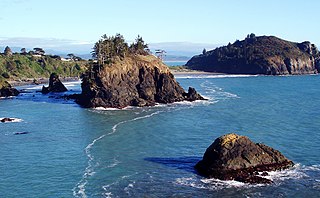
Trinidad State Beach is a state beach 20 miles (30 km) north of Eureka in Humboldt County, California. The offshore rocks are part of the California Coastal National Monument. Colorful tide pools provide specimens to Humboldt State University's Fred Telonicher Marine Laboratory located in Trinidad.

Moss Landing State Beach is a state park on Monterey Bay, in Monterey County, California.

Salinas River State Beach is a beach at the river mouth of the Salinas River at Monterey Bay, in Monterey County, California.

The geological history of Point Lobos, regarding the Point Lobos headland on the Central Coast in Monterey County, California.
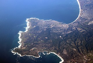
The Monterey Peninsula anchors the northern portion on the Central Coast of California and comprises the cities of Monterey, Carmel, and Pacific Grove, and the resort and community of Pebble Beach.


