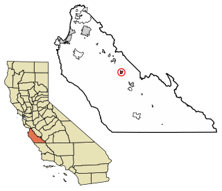
Greenfield is a city in Monterey County, California, United States. Formerly Clarke Colony, it lies in the Salinas Valley, 33 miles (53 km) southeast of Salinas, at an elevation of 289 feet (88 m). As of the 2020 census, the population was 18,937, up from 16,330 in the 2010 census. Its most well-known public event is the annual Harvest Festival. Greenfield is a member of the Association of Monterey Bay Area Governments.

Soledad is a city in Monterey County, California, United States. It is in the Salinas Valley, 21 miles (34 km) southeast of Salinas, the county seat. Soledad's population was 24,925 at the 2020 census, down from 25,738 in 2010. Soledad's origins started with Mission Nuestra Señora de la Soledad, founded by the Spanish in 1791, under the leadership of Fermín de Lasuén. Catalina Munrás began developing the town of Soledad on her Rancho San Vicente in the 1860s, which eventually incorporated as a city in 1921. Today, Soledad is a notable tourist destination, owing to the heavily restored mission, its proximity to Pinnacles National Park, and its numerous vineyards, as part of the Monterey wine region.

The Salinas Valley is one of the major valleys and most productive agricultural regions in California. It is located west of the San Joaquin Valley and south of San Francisco Bay and the Santa Clara Valley.

The Salinas River is the longest river of the Central Coast region of California, running 175 miles (282 km) and draining 4,160 square miles (10,800 km2). It flows north-northwest and drains the Salinas Valley that slices through the central California Coast Ranges south of Monterey Bay. The river begins in southern San Luis Obispo County, originating in the Los Machos Hills of the Los Padres National Forest. From there, the river flows north into Monterey County, eventually making its way to connect with the Monterey Bay, part of the Pacific Ocean, approximately 5 miles (8.0 km) south of Moss Landing. The river is a wildlife corridor, and provides the principal source of water from its reservoirs and tributaries for the farms and vineyards of the valley.

The Santa Lucia Mountains or Santa Lucia Range is a rugged mountain range in coastal central California, running from Carmel southeast for 140 miles (230 km) to the Cuyama River in San Luis Obispo County. The range is never more than 11 miles (18 km) from the coast. The range forms the steepest coastal slope in the contiguous United States. Cone Peak at 5,158 feet (1,572 m) tall and three miles (5 km) from the coast, is the highest peak in proximity to the ocean in the lower 48 United States. The range was a barrier to exploring the coast of central California for early Spanish explorers.

Carmel Valley is an American Viticultural Area (AVA) located in Monterey County, California, southeast of Carmel-by-the-Sea and it is one of the ten AVAs in the county. Approximately 100 miles (161 km) south of San Francisco, the AVA was recognized by the Bureau of Alcohol, Tobacco and Firearms (ATF), Treasury on January 13, 1983 after reviewing the petition submitted by Mr. David Armanasco, General Manager of Dumey Vineyard, located in Carmel, to propose a viticultural area named “Carmel Valley.”

Carmel Valley is an unincorporated community in Monterey County, California, United States. The term "Carmel Valley" generally refers to the Carmel River watershed east of California State Route 1, and not specifically to the smaller Carmel Valley Village. For statistical purposes, the United States Census Bureau has defined Carmel Valley as a census county division (CCD), with an area covering approximately 189 square miles (490 km2). At the time of the 2020 census the CCD population was 6,189. In November 2009, a majority of residents voted against incorporation.

Arroyo Seco is an American Viticultural Area (AVA) in Monterey County, California, southeast of Monterey Bay. The appellation encompasses 18,240 acres (29 sq mi) in the valley adjacent to the Arroyo Seco Creek with approximately 8,500 acres (3,440 ha) of cultivation. The region's proximity to the Pacific Ocean produces the maritime climate, and is best suited for those cool climate grape varieties.

Chalone identifies the first American Viticultural Area (AVA) established in Monterey County, California straddling its border with San Benito County where it is the second established AVA. Chalone viticultural area is located in the Gabilan Mountains east of Soledad. It was recognized by the Bureau of Alcohol, Tobacco and Firearms (ATF) effective on July 14, 1982 after reviewing the petition submitted by the Gavilan Vineyards, Inc. to establish a viticultural area in Monterey and San Benito counties to be named "The Pinnacles." The area encompasses 8,640 acres (14 sq mi) and the proposed name was recognition of the nearby Chalone peaks.
Arroyo Seco may refer to:

J. Lohr Vineyards & Wines is a winemaking company headquartered in San Jose, California, with over 4,000 acres of estate vineyards in the Paso Robles AVA in San Luis Obispo County, Arroyo Seco and Santa Lucia Highlands AVAs in Monterey County, and the St. Helena AVA in Napa Valley, California. The family-owned and operated company was founded by Jerry Lohr in 1974. The company operates wineries in San Jose, Paso Robles, and Greenfield, California. In 2013, Steve Lohr was appointed CEO of the company. J. Lohr Vineyards & Wines’ product portfolio includes eight tiers of wine: J. Lohr Signature, J. Lohr Cuvée Series, J. Lohr Vineyard Series, J. Lohr Gesture, J. Lohr Pure Paso Proprietary Red Wine, J. Lohr Monterey Roots, J. Lohr Estates and ARIEL Vineyards. The portfolio also includes specialty brands Cypress Vineyards and Painter Bridge. J. Lohr ranks among the top 25 wine producers in the United States, with annual US sales exceeding 1.8 million cases.
The Hames Valley AVA is an American Viticultural Area located in Monterey County, California at about 35°52'N 120°52'W, about 2 km west of US Route 101. It became an AVA in 1994. It is part of the larger Monterey AVA, and is located at the southern end of the Salinas Valley in the foothills of the Santa Lucia Range. The soil in the valley is shale and loam, and the climate is slightly warmer than other regions of Monterey. In addition to Bordeaux varietals, traditional Port grapes such as Tinta Cao and Touriga Nacional are grown in the valley. One recent significant wine is the 2008 Nybakken "IV Amici" Petite Syrah.
The Santa Lucia Highlands AVA is an American Viticultural Area located in Monterey County, California. It is part of the larger Monterey AVA, and located in the Santa Lucia Mountains above the Salinas Valley. Over 2,300 acres (931 ha) of vineyards are planted in the AVA, some as high as 1,200 feet (366 m) above sea level, with about half of them planted to the Pinot noir grape. The region enjoys cool morning fog and breezes from Monterey Bay followed by warm afternoons thanks to direct southern exposures to the sun.
There are 21 routes assigned to the "G" zone of the California Route Marker Program, which designates county routes in California. The "G" zone includes county highways in Monterey, San Benito, San Luis Obispo, Santa Clara, and Santa Cruz counties.

The Arroyo Seco is a major tributary of the Salinas River in central California. About 40 miles (64 km) long, it drains a rugged area of the Coast Ranges east of Big Sur before flowing through the agricultural Salinas Valley.

Testarossa is a winery and tasting room in Los Gatos, California. Testarossa makes multiple varietals and is known primarily for making Chardonnay and Pinot Noir wines.

Pisoni Estate is a family-owned and operated vineyard and winery located in the Santa Lucia Highlands of California’s Monterey Coast. It was founded in 1982 by Gary Pisoni, who was more interested in growing wine grapes than row crops for the family vegetable farm. He decided to plant a vineyard in the mountains above the Salinas Valley--an area previously considered undesirable for growing because of its dry, granitic soil. The vineyard began with small crops of Chardonnay, Cabernet Sauvignon, and Pinot Noir, then eventually focused on the Pinot Noir for which it has become renowned.

Monterey County wine is a appellation that designates wine made from grapes grown in Monterey County, California which lies entirely within the expansive multi-county Central Coast viticultural area. County names in the United States automatically qualify as legal appellations of origin for wine produced from grapes grown in that county and do not require registration with the Alcohol and Tobacco Tax and Trade Bureau (TTB). TTB was created in January 2003, when the Bureau of Alcohol, Tobacco and Firearms, or ATF, was extensively reorganized under the provisions of the Homeland Security Act of 2002.

Gabilan Mountains is an American Viticultural Area (AVA) located in the mountainous region on the border in Monterey and San Benito Counties in California. It is the tenth and newest AVA established in Monterey County by the Alcohol and Tobacco Tax and Trade Bureau (TTB) on September 14, 2022, becoming the state's 147th official AVA after the TTB reviewed the petition from Parker Allen of Coastview Vineyards, proposing to establish the "Gabilan Mountains" viticultural area. Gabilan Mountains encompasses about 98,000 acres (153 sq mi) including the established Mt. Harlan and Chalone AVAs, and resident to 4 wineries and 6 commercial vineyards cultivating approximately 436 acres (176 ha). The average elevation within the region is 2,370 feet (722 m) placing it above the heavy fog and marine layer. As a result, Gabilan Mountains AVA has a cool air climate without the humidity from the fog and low-lying clouds.


