
Mendocino County is a county located on the North Coast of the U.S. state of California. As of the 2020 census, the population was 91,601. The county seat is Ukiah.

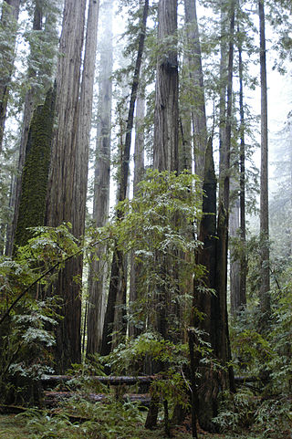
Humboldt Redwoods State Park is a state park of California, United States, containing Rockefeller Forest, the world's largest remaining contiguous old-growth forest of coast redwoods. It is located 30 miles (48 km) south of Eureka, California, near Weott in southern Humboldt County, within Northern California, named after the great German nineteenth-century scientist, Alexander von Humboldt. The park was established by the Save the Redwoods League in 1921 largely from lands purchased from the Pacific Lumber Company. Beginning with the dedication of the Raynal Bolling Memorial Grove, it has grown to become the third-largest park in the California State Park system, now containing 51,651 acres (20,902 ha) through acquisitions and gifts to the state.

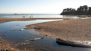
The Navarro River is a 28.3-mile-long (45.5 km) river in Mendocino County, California, United States. It flows northwest through the Coastal Range to the Pacific Ocean. The main stem of the Navarro River begins less than 1 mile (2 km) south of the town of Philo at the confluence of Rancheria Creek and Anderson Creek. The mouth of the Navarro is 10 miles (16 km) south of the city of Mendocino. State Route 128 starts from the intersection of State Route 1 at the mouth of the Navarro River, and follows the river valley upstream to Philo. The river is close to the highway through the lower canyon but is some distance south of the highway as the Anderson Valley widens upstream of Wendling.

Portola Redwoods State Park is a 2,800 acres (1,100 ha) state park in California situated in San Mateo County. The parks' primary watercourses — Peters Creek, Pescadero Creek and their associated tributaries — converge at Portola Redwoods State Park. Tip Toe Falls is a small waterfall along Fall Creek, a tributary of Pescadero Creek.

The Mendocino Woodlands State Park is a group camping facility located at 39350 Little Lake Road, Mendocino County, California, seven miles (11 km) inland from the town of Mendocino. It was built as a Recreational Demonstration Area by the Civilian Conservation Corps. Mendocino Woodlands consists of approximately 700 acres (2.8 km2) of land along the Little North Fork of the Big River and is surrounded to the north, east, and west by the 50,000-acre (200 km2) Jackson Demonstration State Forest. To the south, the park abuts the Big River State Park. It was declared a National Historic Landmark on September 25, 1997.
Van Damme State Park is a public beach consisting of about 1,831 acres (7.41 km2) of land in Mendocino County, California, near the town of Little River on State Route 1. It was named for Charles F. Van Damme (1881–1934), who was born in the area and purchased the land that is now the park with profits from a San Francisco ferry business. On his death, the property became part of the California state park system.

Navarro River Redwoods State Park is a state park in Mendocino County, California, consisting of 660 acres (2.7 km2) of second-growth redwood forest in a narrow stretch 11 miles (18 km) long on both banks of the Navarro River, from the town of Navarro to the river's confluence with the Pacific Ocean.

Hendy Woods State Park is a California state park, located in the Anderson Valley of Mendocino County. It is known for its old-growth coast redwoods and also provides camping facilities near the wineries of the Anderson Valley. It is named after Joshua Hendy, who owned the land and stipulated that it be protected; it passed through several owners after Hendy without being logged, before becoming part of the California State Park system in 1958.
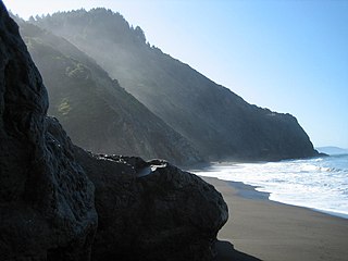
The Lost Coast is a mostly natural and undeveloped area of the California North Coast in Humboldt and Mendocino Counties, which includes the King Range. It was named the "Lost Coast" after the area experienced depopulation in the 1930s. In addition, the steepness and related geotechnical challenges of the coastal mountains made this stretch of coastline too costly for state highway or county road builders to establish routes through the area, leaving it the most undeveloped and remote portion of the California coast. Without any major highways, communities in the Lost Coast region such as Petrolia, Shelter Cove, and Whitethorn are somewhat isolated from the rest of California.

Montgomery Woods State Natural Reserve is a 1,323-acre state-owned park located in the Coastal Range in Mendocino County, California, United States. The Reserve occupies the headwaters of Montgomery Creek, a tributary of Big River, which flows into the Pacific Ocean at Mendocino Headlands State Park. The virgin groves of Coast Redwood in Montgomery Woods are examples of a now rare upland riparian meadow habitat; most other preserved redwood groves are on broad alluvial plains. The Reserve is accessed from a parking area along Orr Springs Road 13 miles (21 km) west of Ukiah and 15 miles (24 km) east of Comptche. A moderately steep trail from the parking area climbs uphill along Montgomery Creek about three-quarters of a mile. Once in the grove, the trail makes a meandering three miles (4.8 km) loop, with substantial use of boardwalks to protect the fragile forest floor. The reserve was initiated by a 9-acre donation from Robert T. Orr in 1945, with 765 acres donated since 1947 by the Save the Redwoods League.

Lake Pillsbury is a lake in the Mendocino National Forest of Lake County, California, created from the Eel River and Hull Mountain watershed by Scott Dam. Elevation is 1,818 ft (554 m) with 65 mi (105 km) of shoreline and covering 2,003 acres (811 ha). Activities in the Lake Pillsbury Recreation Area include powerboating, fishing, swimming, sailing, picnicking, hiking and hang gliding. There are two main access roads to the lake. At the north end of the lake is a small gravel airstrip. About 400 vacation cabins including National Forest Recreational Residences ring the lake.

Jackson Demonstration State Forest is a public forest in Mendocino County, California managed by the California Department of Forestry and Fire Protection. It is the largest demonstration forest operated by the State of California. The forest land, located along California State Highway 20 between Willits and the coastal city of Fort Bragg, was formerly owned by Caspar Lumber Company. The forest holds sacred value as an ancestral home and ceremonial site for the Coyote Valley Band of Pomo Indians.

Richardson Grove State Park is located at the southernmost border of Humboldt County, 75 miles (121 km) south of Eureka, California, United States, and 200 miles (320 km) north of San Francisco. The year-round park, which has approximately 2,000 acres (8.1 km2), straddles US 101, causing the narrowest point of its entire distance. Said to have the 9th largest tree of all remaining Coast Redwoods, it is known for swimming on the South Fork of the Eel River and day use in addition to 159 campsites.
The Sherwood Valley Rancheria of Pomo Indians of California is a federally recognized tribe of Pomo Indians in California.
Bull Creek is a locality 11 miles (18 km) south-southeast of Scotia, at an elevation of 7 feet (2.1 m) in Humboldt County, California. Bull Creek Road parallels Bull Creek and is also known as the Mattole Road.
Smithe Redwoods State Natural Reserve is a California state park in Mendocino County. In the early 20th century, the site was purchased by Mulford Miller and W. A. S. Foster, before passing into the hands of W. S. Ware and Lester Goble in 1940. Originally a site known as Lane's Redwood Flat, the area contained cabins, a store, a post office, and a bus stop during that incarnation. In 1963, the site was proposed to be sold to a logging company, but instead entered the jurisdiction of the California Department of Parks and Recreation. The South Fork Eel River passes through the park, which contains a waterfall, as well as sites for recreation on the river and picnicking.
Pyramid Ridge is a 3,520–3,560 feet (1,070–1,090 m) mountain in Mendocino County, California.
The InterTribal Sinkyone Wilderness Council is a consortium of Northern California tribal nations focused on environmental and cultural preservation. The council, which includes members of 10 federally recognized tribes in Mendocino and Lake counties, has worked to protect lands of cultural importance along the North Coast within the traditional Sinkyone tribal territory since it was established in 1986. Nonprofit and governmental organizations have cooperated with the council in the restoration of property to descendants of its original inhabitants which is part of an effort to return Indigenous lands and autonomy to Indigenous communities. After the invasion of the traditional Sinkyone tribal territory by multitudes of Euro-American settlers in the mid-1850s, Sinkyone people eventually became enrolled members at several tribes located throughout the region. The council is made up of the Cahto Indian Tribe of the Laytonville Rancheria, Coyote Valley Band of Pomo Indians, Hopland Band of Pomo Indians, Pinoleville Pomo Nation, Potter Valley Tribe, Redwood Valley Rancheria of Pomo Indians, Robinson Rancheria of Pomo Indians, Round Valley Indian Tribes, Scotts Valley Band of Pomo Indians and Sherwood Valley Rancheria of Pomo Indians.
Sequoia County was a proposal in the early 1990s, to create a new county out of parts of Southern Humboldt and Northern Mendocino counties in California. The 1992 proposal halted signature gathering due to low support. The proponents of the proposal, restarted in 1993, submitted signatures in January 1994 to the Humboldt County clerk, who validated 2,033 signatures, 169 short of the necessary number to qualify for possible inclusion on the 1996 ballot.
The Great Redwood Trail is a proposed multi-use rail-to-trail project connecting San Francisco and Humboldt bays in Northern California. Most of the trail will be built on the rail bed of the defunct Northwestern Pacific Railroad along the Eel River Canyon by the Great Redwood Trail Agency. The southern portion will be built by Sonoma–Marin Area Rail Transit (SMART) along their commuter rail line. The trail route is within 5 counties, 14 cities and the ancestral territory of many tribes. Some portions have already constructed by local jurisdictions with more being developed in cooperation with local governments.
