The University of California Natural Reserve System (UCNRS) is a system of protected areas throughout California.
The San Jacinto Mountains are a mountain range in Riverside County, located east of Los Angeles in southern California in the United States. The mountains are named for one of the first Black Friars, Saint Hyacinth, who is popular patron in Latin America.
California is a state in the Pacific Region of the United States. With 39.6 million residents, California is the most populous U.S. state and the third-largest by area. The state capital is Sacramento. The Greater Los Angeles Area and the San Francisco Bay Area are the nation's second and fifth most populous urban regions, with 18.7 million and 9.7 million residents respectively. Los Angeles is California's most populous city, and the country's second most populous, after New York City. California also has the nation's most populous county, Los Angeles County, and its largest county by area, San Bernardino County. The City and County of San Francisco is both the country's second-most densely populated major city after New York City and the fifth-most densely populated county, behind only four of the five New York City boroughs.
The University of California, Riverside, is a public research university in Riverside, California. It is one of the 10 general campuses of the University of California system. The main campus sits on 1,900 acres (769 ha) in a suburban district of Riverside with a branch campus of 20 acres (8 ha) in Palm Desert. In 1907 the predecessor to UCR was founded as the UC Citrus Experiment Station, Riverside which pioneered research in biological pest control and the use of growth regulators responsible for extending the citrus growing season in California from four to nine months. Some of the world's most important research collections on citrus diversity and entomology, as well as science fiction and photography, are located at Riverside.
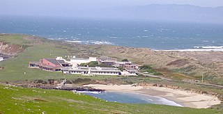
In addition to acting as a protected natural area for teaching and research in the sciences, it is also available as an engineering testing ground for various sensor-related and ecosystem monitoring technologies.
The primary research focus at the James Reserve has been ecological monitoring using ecological sensing systems. Over the internet, researchers, students and the interested public may unobtrusively visit and view nature via a webcam observatory, which includes an interactive robotic camera. Devices in the outdoor laboratory allow non-intrusive, around-the-clock monitoring.
The Director of the Reserve is Dr. Jennifer Gee, who received her Ph.D. from Princeton University, in the field of Ecology and Evolutionary Biology.
Overnight accommodations for researchers and school groups may be made for the on-site Trailfinders Lodge. Visitation is by permission only.
The San Bernardino National Forest is a United States National Forest in Southern California encompassing 823,816 acres (3,333.87 km2) of which 677,982 acres (2,743.70 km2) are federal. The forest is made up of two main divisions, the eastern portion of the San Gabriel Mountains and the San Bernardino Mountains on the easternmost of the Transverse Ranges, and the San Jacinto and Santa Rosa Mountains on the northernmost of the Peninsular Ranges. Elevations range from 2,000 to 11,499 feet. The forest includes seven wilderness areas: San Gorgonio, Cucamonga, San Jacinto, South Fork San Jacinto, Santa Rosa, Cahuilla Mountain and Bighorn Mountain. Forest headquarters are located in the city of San Bernardino. There are district offices in Lytle Creek, Idyllwild, and Fawnskin.
The Santa Rosa and San Jacinto Mountains National Monument is a National Monument in southern California. It includes portions of the Santa Rosa and San Jacinto mountain ranges, the northernmost ones of the Peninsular Ranges system. The national monument covers portions of Riverside County, west of the Coachella Valley, approximately 100 miles (160 km) southeast of downtown Los Angeles.
The Santa Rosa Wilderness is a 72,259-acre (292.42 km2) wilderness area in Southern California, in the Santa Rosa Mountains of Riverside and San Diego counties, California. It is in the Colorado Desert section of the Sonoran Desert, above the Coachella Valley and Lower Colorado River Valley regions in a Peninsular Range, between La Quinta to the north and Anza Borrego Desert State Park to the south. The United States Congress established the wilderness in 1984 with the passage of the California Wilderness Act, managed by the both US Forest Service and the Bureau of Land Management. In 2009, the Omnibus Public Land Management Act was signed into law which added more than 2,000 acres (8.1 km2). Most of the Santa Rosa Wilderness is within the Santa Rosa and San Jacinto Mountains National Monument.
This page is based on this Wikipedia article Text is available under the CC BY-SA 4.0 license; additional terms may apply. Images, videos and audio are available under their respective licenses.
Related Research Articles
Anza-Borrego Desert State Park (ABDSP) is a California state park located within the Colorado Desert of southern California, United States. The park takes its name from 18th century Spanish explorer Juan Bautista de Anza and borrego, the Spanish word for sheep. With 600,000 acres (240,000 ha) that includes one-fifth of San Diego County, it is the largest state park in California.
The Low Desert is a common name for any desert in California that is under 2,000 feet (609.6m) in altitude. These areas include, but are not exclusive to, the Colorado Desert and Yuha Desert, in the Southern California portion of the Sonoran Desert. These areas are distinguished in biogeography from the adjacent northern High Desert or Mojave Desert by latitude, elevation, animal life, climate, and native plant communities.
San Jacinto Peak is the highest peak of the San Jacinto Mountains, and of Riverside County, California. It lies within Mount San Jacinto State Park. Naturalist John Muir wrote of San Jacinto Peak, "The view from San Jacinto is the most sublime spectacle to be found anywhere on this earth!"
The Santa Rosa Mountains are a short mountain range in the Peninsular Ranges system, located east of the Los Angeles Basin and northeast of the San Diego metropolitan area of southern California, in the southwestern United States.
State Route 74, part of which forms the Palms to Pines Scenic Byway or Pines to Palms Highway, and the Ortega Highway, is a highway in the U.S. state of California. It runs from San Juan Capistrano in Orange County to Palm Desert in Riverside County, stretching a total of 111 miles.
The Santa Margarita River which with the addition of what is now Temecula Creek, was formerly known as the Temecula River, is a short intermittent river on the Pacific coast of southern California in the United States, approximately 30.9 miles (49.7 km) long. One of the last free-flowing rivers in southern California, it drains an arid region at the southern end of the Santa Ana Mountains, in the Peninsular Ranges between Los Angeles and San Diego.
Cleveland National Forest encompasses 460,000 acres, mostly of chaparral, with a few riparian areas. A warm dry mediterranean climate prevails over the Forest. It is the southernmost National forest of California. It is administered by the United States Forest Service, a government agency within the United States Department of Agriculture. It is divided into the Descanso, Palomar and Trabuco Ranger Districts and is located in the counties of San Diego, Riverside, and Orange.
The San Bernardino Valley is a valley in Southern California. It lies at the south base of the Transverse Ranges. It is bordered on the north by the eastern San Gabriel Mountains and the San Bernardino Mountains; on the east by the San Jacinto Mountains; and on the south by the Temescal Mountains and Santa Ana Mountains; and on the west by the Pomona Valley. Elevation varies from 180 metres (590 ft) on valley floors near Chino, where it gradually increases to about 420 metres (1,380 ft) near San Bernardino and Redlands. The valley floor houses roughly over 80% of the over 4 million total human population in the Inland Empire region.
The Mojave and Colorado Deserts Biosphere Reserve is a biosphere reserve designated by UNESCO in 1984 to promote the ecological conservation of a cluster of areas in the Mojave and Colorado deserts of California. A principal feature is Death Valley. The four management units encompassed by the reserve upon its creation were:
Agua Tibia Wilderness (ATW) is a 17,961-acre (72.69 km2) protected area in Riverside and San Diego counties, in the U.S. state of California. It is mostly within the Palomar Ranger District of the Cleveland National Forest. The area was originally protected as the Agua Tibia Primitive Area until January 1975 when it was added to the National Wilderness Preservation System with the passage of Public Law 93-632 by the United States Congress. Between its inception and 1984, the ATW was San Diego County's only officially designated wilderness area. The Spanish name, Agua Tibia, translates as warm water.
The Santa Rosa Plateau is an upland plateau and southeastern extension of the Santa Ana Mountains in Riverside County, southern California. It is bounded by the rapidly urbanizing Inland Empire cities of Murrieta to the northeast, and Temecula to the southeast.
The Landels-Hill Big Creek Reserve is a constituent of the University of California Natural Reserve System. It is located off State Route 1 in the Big Sur area on California's central coast, fifty miles south of Monterey and adjacent to the Big Creek State Marine Reserve and Big Creek State Marine Conservation Area.
Mount San Jacinto State Park is in the San Jacinto Mountains, of the Peninsular Ranges system, in Riverside County, California, United States. A majority of the park is within the Santa Rosa and San Jacinto Mountains National Monument. The park is near the Greater Los Angeles and the San Diego metropolitan area.
Riverside County is one of fifty-eight counties in the U.S. state of California. As of the 2010 census, the population was 2,189,641, making it the 4th-most populous county in California and the 11th-most populous in the United States. The name was derived from the city of Riverside, which is the county seat.
The Philip L. Boyd Deep Canyon Desert Research Center is one of the original seven of the total 39 sites in the University of California Natural Reserve System. It contains lands originally donated to the University by regent Philip L. Boyd in 1958. The Research Center is contained within UNESCO's Mojave and Colorado Deserts Biosphere Reserve.