
Jamul is a census-designated place (CDP) in San Diego County, California, United States. Jamul had a population of 6,163 at the 2010 census.

Campo is an unincorporated community in the Mountain Empire area of southeastern San Diego County, California, United States. The population was 2,684 at the 2010 census. For statistical purposes, the United States Census Bureau has defined Campo as a census-designated place (CDP). The census definition of the area may not precisely correspond to local understanding of the area with the same name.
The Yalakom River is a tributary of the Bridge River, which is one of the principal tributaries of the Fraser River, entering it near the town of Lillooet, British Columbia. In frontier times it was also known as the North Fork of the Bridge River, and joins the Bridge River proper at Moha, a rural community with a history in ranching, farming and mining. The river is approximately 50km in length. The valley's climate is semi-arid in character and lodgepole pine predominates below treeline.

The Fish Creek Mountains Wilderness is located about 25 miles west of Brawley, California, and southeast of the Vallecito Mountains in the United States. The wilderness is located in the Fish Creek Mountains region in the northern part of the Carrizo Impact Area, which is closed to the public.

Located in northern California, the Suisun Marsh has been referred to as the largest brackish water marsh on west coast of the United States of America. The marsh land is part of the San Francisco Bay tidal estuary, and subject to tidal ebb and flood. The marsh is home to many species of birds and other wildlife, and is formed by the confluence of the Sacramento and San Joaquin rivers between Martinez and Suisun City, California and several other smaller, local watersheds. Adjacent to Suisun Bay, the marsh is immediately west of the legally defined Sacramento-San Joaquin Delta as well as part of the San Francisco Bay estuary.
Wildwood Canyon is a canyon and California state park in the eastern foothills of the San Bernardino Mountains, within San Bernardino County, southern California.
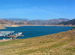
Pine Flat Lake is an artificial lake or reservoir in the Sierra Nevada foothills of eastern Fresno County, California on the western north-south border to the Sierra- and Sequoia National Forests, about 30 mi (48 km) east of Fresno. The lake is managed by the U.S. Army Corps of Engineers (USACE) and is open to boaters, campers & hikers.
The Oregon Department of Fish and Wildlife (ODFW) is a government agency of the U.S. state of Oregon responsible for programs protecting Oregon fish and wildlife resources and their habitats. The agency operates hatcheries, issues hunting and angling licenses, advises on habitat protection, and sponsors public education programs. Its history dates to the 1878 establishment of the office of Columbia River Fish Warden. Since 1931, enforcement of Oregon's Fish and Game laws has been the responsibility of the Oregon State Police rather than separate wardens.
The Jamul Indian Village of California is a federally recognized tribe of Kumeyaay Indians, who are sometimes known as Mission Indians.

The Kofa National Wildlife Refuge is located in Arizona in the southwestern United States, northeast of Yuma and southeast of Quartzsite. The refuge, established in 1939 to protect desert bighorn sheep, encompasses over 665,400 acres (2,693 km2) of the Yuma Desert region of the Sonoran Desert. Broad, gently sloping foothills as well as the sharp, needlepoint peaks of the Kofa Mountains are found in the rugged refuge. The small, widely scattered waterholes attract a surprising number of water birds for a desert area. A wide variety of plant life is also found throughout the refuge.

The North Table Mountain Ecological Reserve is a nature reserve of 3,315 acres (13.42 km2) located three miles (5 km) north of Oroville, in Butte County, northern California. The land was acquired by the state in October, 1993.

Columbia National Wildlife Refuge is a scenic mixture of rugged cliffs, canyons, lakes, and sagebrush grasslands. Formed by fire, ice, floods, and volcanic tempest, carved by periods of extreme violence of natural forces, the refuge lies in the middle of the Drumheller Channeled Scablands of central Washington. The area reveals a rich geologic history highlighted by periods of dramatic activity, each playing a major role in shaping the land. The northern half of the refuge, south of Potholes Reservoir, is a rugged jumble of cliffs, canyons, lakes, and remnants of lava flows. This part of the Scablands, known as the Drumheller Channels, is the most spectacularly eroded area of its size in the world and was designated as a National Natural Landmark in 1986.
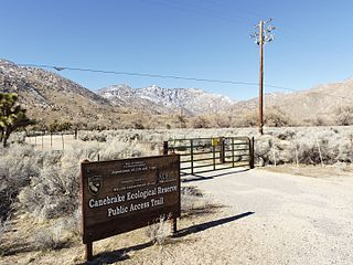
Canebrake Ecological Reserve is a 6,700-acre (27 km2) nature reserve in the South Fork Valley of Kern County, 20 miles (32 km) east of Lake Isabella, California. It is located in the Southern Sierra Nevada region.

Soquel Canyon State Marine Conservation Area (SMCA) is an offshore marine protected area in Monterey Bay. Monterey Bay is on California’s central coast with the city of Monterey at its south end and the city of Santa Cruz at its north end. The SMCA covers 23.41 square miles (60.6 km2). Within the SMCA, fishing and taking of any living marine resources is prohibited except the commercial and recreational take of pelagic finfish.
Putah Creek Wildlife Area is a state wildlife area of Solano County, California. The 670 acre reserve lies to the southeast of Lake Berryessa, to the south of Monticello Dam and the confluence of Putah Creek and Cold Creek. Trees found here include cottonwood, blue oak and chaparral. Deer, quail, California towhee, Bullock's oriole, and black-headed grosbeak are also found in the area, which also includes Stebbins Cold Canyon Reserve.
San Felipe Creek is a stream in Imperial and San Diego Counties of California. It arises in the Volcan Mountains of San Diego County 33°11′57″N116°37′35″W, and runs eastward, gathering the waters of most of the eastern slope of the mountains and desert of the county before it empties into the Salton Sea. It is probably the last remaining perennial natural desert stream in the Colorado Desert region. In 1974, the San Felipe Creek Area was designated as a National Natural Landmark by the National Park Service.

Tahquitz Canyon is located in Palm Springs, California on a section of the Agua Caliente Indian Reservation. The canyon descends from the Riverside County San Jacinto Mountains. It was continually inhabited for at least 5,000 years by the Native American Cahuilla people, and is one of many canyons of cultural significance to the Cahuilla. Today it is a nature preserve open to the public that is overseen by the Agua Caliente Band of Cahuilla Indians.

McGinty Mountain is a gabbroic mountain located in San Diego County, California near Jamul. Because of the gabbroic soil, the mountain supports numerous rare and endemic plant species, including half of the California's population of the Dehesa nolina. The mountain belongs to an ecological preserve collectively managed by The Nature Conservancy, the California Department of Fish and Wildlife, and the San Diego National Wildlife Refuge. The mountain is accessible through a 4.7 mi (7.6 km) long out-and-back hiking trail.

