Bedrock mortar

Last updated
BRM in a rock shelter on the Upper Cumberland Plateau. Bedrock mortar in a rock shelter on the Upper Cumberland Plateau.jpg
BRM in a rock shelter on the Upper Cumberland Plateau.

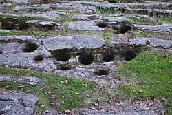
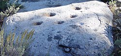
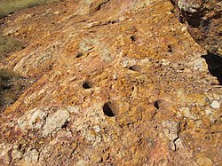
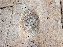
A bedrock mortar (BRM) is an anthropogenic circular depression in a rock outcrop or naturally occurring slab, used by people in the past for grinding of grain, acorns or other food products. [1] There are often a cluster of a considerable number of such holes in proximity indicating that people gathered in groups to conduct food grinding in prehistoric cultures. Correspondingly the alternative name gossip stone is sometimes applied, indicating the social context of the food grinding activity. Typical dimensions of the circular indentations are approximately 12 centimeters (4.7 inch) in diameter by 10 centimeters (3.9 inches) deep, although a considerable range of depths of the cavities have been documented . [2] The bedrock mortar has been identified in a number of world regions, but has been particularly intensely documented in the Americas. An alternative term for the bedrock mortar site is bedrock milling station.

Contents

Bedrock metate

A bedrock mortar should not be confused with a bedrock metate, which is a flat, trough-shaped depression often found with bedrock mortars. [3]

Example locations of occurrence

See also

Line note references

  1. "Archaeology online glossary". Archived from the original on 2007-07-01. Retrieved 2007-07-02.
  2. Discovering Prehistoric Sites: Objective and Subjective Survey Techniques, Daniel G. Foster, Brian D. Dillon, and Linda C. Sandelin, California Department of Forestry and Fire Protection, June 13, 2005
  3. "Cultural Resources of the Santa Rita Experimental Range" (PDF). John H. Madsen. Retrieved 4 December 2013.
  4. G. Deghi, J. Buxton et al., Earth Metrics, Environmental Impact Report for the Saxon Creek Water Project, Mariposa County, California, published by the County of Mariposa Planning Department and Mariposa County Water Agency, Report 10298, May, 1990
  5. "Stumbling Upon Chumash Bedrock Mortars". 6 July 2012.
  6. "C. Melvin Aikens, Cultural Continuity in the Sierra Tarahumara of Southern Chihuahua, Mexico, June 2003". Archived from the original on 2007-05-27. Retrieved 2007-07-02.
  7. M. Del Pilar Babot, María C. Apella, Maize and Bone: Residues of Grinding in Northwestern Argentina, Archaeometry, Volume 45 Issue 1 Page 121-132, February 2003

Related Research Articles

<span class="mw-page-title-main">Mortar and pestle</span> Equipment consisting of a bowl in which substances are ground using a pestle

A mortar and pestle is a set of two simple tools used to prepare ingredients or substances by crushing and grinding them into a fine paste or powder in the kitchen, laboratory, and pharmacy. The mortar is characteristically a bowl, typically made of hard wood, metal, ceramic, or hard stone such as granite. The pestle is a blunt, club-shaped object. The substance to be ground, which may be wet or dry, is placed in the mortar where the pestle is pounded, pressed, or rotated into the substance until the desired texture is achieved.

<span class="mw-page-title-main">Maidu</span> Native American people of northern California

The Maidu are a Native American people of northern California. They reside in the central Sierra Nevada, in the watershed area of the Feather and American Rivers and in Humbug Valley. In Maiduan languages, maidu means "man".

<span class="mw-page-title-main">Sierra Madre Occidental</span> Mountain range along the Pacific coast of Mexico

The Sierra Madre Occidental is a major mountain range system of the North American Cordillera, that runs northwest–southeast through northwestern and western Mexico, and along the Gulf of California. The Sierra Madre is part of the American Cordillera, a chain of mountain ranges (cordillera) that consists of an almost continuous sequence of mountain ranges that form the western 'sounds' of North America, Central America, South America, and West Antarctica.

<span class="mw-page-title-main">Ahwahnechee</span> Native American tribe in Yosemite Valley

The Ahwahnechee are a Native American people who traditionally lived in the Yosemite Valley and still live in surrounding area. They are the seven tribes of Yosemite Miwok, Northern Paiute, Kucadikadi Mono Lake people. As one of the most documented tribes the tribe still fights for Federal Recognition. The Ahwahnechee people's heritage can be found all over Yosemite National Park.

<span class="mw-page-title-main">Sentinel Peak (Arizona)</span> Mountain in Arizona, United States

Sentinel Peak is a 2,897 ft (900 m) peak in the Tucson Mountains southwest of downtown Tucson, Arizona, United States. The valley's first inhabitants grew crops at the mountain's base, along the Santa Cruz River. The name "Tucson" is derived from the O'odham Cuk Ṣon, meaning "[at the] base of the black [hill]". In the 1910s, University of Arizona students used local basalt rock to construct a 160 ft (50 m) tall block "A" on the mountain's east face, near its summit, giving the peak its other name, "A" Mountain. The peak is part of a 272-acre park, the largest natural resource park in the City of Tucson.

<span class="mw-page-title-main">Indian Grinding Rock State Historic Park</span> Archaeological site in Amador county, California

Indian Grinding Rock State Historic Park is a California State Park, preserving an outcropping of marbleized limestone with some 1,185 mortar holes—the largest collection of bedrock mortars in North America. It is located in the Sierra Nevada foothills, 8 miles (13 km) east of Jackson. The park is nestled in a little valley 2,400 feet (732 m) above sea level, with open meadows and large specimens of valley oak that once provided the Miwok peoples of this area with an ample supply of acorns. The 135-acre (55 ha) park was established in 1962 and listed on the National Register of Historic Places in 1971.

<span class="mw-page-title-main">Metate</span> Mesoamerican quern or milling-stone

A metate is a type or variety of quern, a ground stone tool used for processing grain and seeds. In traditional Mesoamerican cultures, metates are typically used by women who would grind nixtamalized maize and other organic materials during food preparation. Similar artifacts have been found in other regions, such as the sil-batta in Bihar and Jharkhand, India as well as other grinding stones in China.

<span class="mw-page-title-main">Indian Rock Park</span>

Indian Rock Park is a 1.18-acre (4,800 m2) public park at 950 Indian Rock Avenue in the city of Berkeley, California, on the slope of the Berkeley Hills. It is located in the northeast part of the city, about two blocks north of the Arlington/Marin Circle, and straddles Indian Rock Avenue. The central feature of the park is a large rock outcropping on the west side of Indian Rock Ave. The larger portion of the park, on the opposite side of the street, has several much smaller rock outcroppings, grass fields, and a small barbecue and picnic area. The rock is composed of Northbrae rhyolite.

<span class="mw-page-title-main">Santa Rosa Plateau</span> California geographical feature

The Santa Rosa Plateau is an upland plateau and southeastern extension of the Santa Ana Mountains in Riverside County, southern California. It is bounded by the rapidly urbanizing Inland Empire cities of Murrieta and Temecula to the northeast and southeast, respectively.

The Pauma Complex is a prehistoric archaeological pattern among indigenous peoples of California, initially defined by Delbert L. True in northern San Diego County, California.

Burrough Valley, California is located in the Sierra Nevada foothills of eastern Fresno County, approximately thirty miles northeast of Fresno, California, at an elevation of about 1,600 feet (490 m) above sea level. The small valley covers approximately 4,000 acres (16 km2).

Santiago Canyon is a canyon and unincorporated community in South Orange County, California. According to the 2000 census, Santiago Canyon has several hundred residents living within its borders. Trabuco Canyon, Silverado Canyon, Modjeska Canyon and Williams Canyon are tributaries of Santiago Canyon. Santiago Creek flows northwest from the canyon, then west into the Santa Ana River. Neighborhoods in Santiago Canyon include Santiago Canyon Estates and Falcon View Estates. The landmark Cook's Corner motorcycle restaurant is also located within Santiago Canyon.

<i>Calochortus clavatus</i> Species of flowering plant

Calochortus clavatus is a species of mariposa lily known by the common name clubhair mariposa lily. It is endemic to California where it is found in forests and on chaparral slopes.

<span class="mw-page-title-main">Bald Rock Dome</span>

Bald Rock is a granite summit located in Butte County, California, in the Plumas National Forest. Located close to Lake Oroville, the dome peak overlooks Sacramento Valley and coastal mountain ranges.

<span class="mw-page-title-main">Cueva de la Olla (archaeological site)</span> Archaeological site

Cueva de la Olla is an archaeological site located in the northwest of the Chihuahua State, some 47 km southwest of Nuevo Casas Grandes near the Ignacio Zaragoza Ejido.

Cueva de la Ranchería is an archaeological site located south of Ciudad Madera, in the Sirupa Canyon region, northwest of the Mexican state of Chihuahua.

<span class="mw-page-title-main">Late Basketmaker II Era</span> Ancient culture of the southwest United States

The Late Basketmaker II Era was a cultural period of Ancient Pueblo People when people began living in pit-houses, raised maize and squash, and were proficient basket makers and weavers. They also hunted game and gathered wild foods, such as pinyon nuts.

<span class="mw-page-title-main">Mano (stone)</span> Hand-held stone tool used with a metate or quern to process or grind food by hand

A mano is a ground stone tool used with a metate to process or grind food by hand. It is also known by the Nahuatl term metlapil.

<span class="mw-page-title-main">Huerfano Butte (Arizona)</span> Summit in Pima County, Arizona, US

Huerfano Butte is a small rocky butte located on the western flank of the Santa Rita Mountains in southeastern Pima County, Arizona. With an elevation of 3,992 ft (1,217 m), Huerfano Butte is one of the dominant landmarks in the 52,000-acre (21,000 ha) Santa Rita Experimental Range, as well as an important prehistoric archaeological site.

<span class="mw-page-title-main">Chumash Indian Museum</span> Chumash Interpretive Center in Thousand Oaks, CA

Chumash Indian Museum is a Native American Interpretive Center in northeast Thousand Oaks, California. It is the site of a former Chumash village, known as Sap'wi. It is located in Oakbrook Regional Park, a 432-acre park which is home to a replica of a Chumash village and thousand year-old Chumash pictographs. The pictographs by nearby Birthing Cave are not open to the public, but can be observed on docent-led tours. Chumash people inhabited the village 10,000 years ago.