Related Research Articles

Marin County is located in the northwestern part of the San Francisco Bay Area of the U.S. state of California. As of the 2020 census, the population was 262,231. Its county seat and largest city is San Rafael. Marin County is across the Golden Gate Bridge from San Francisco, and is included in the San Francisco–Oakland–Berkeley, CA Metropolitan Statistical Area.

Muir Woods National Monument is a United States National Monument managed by the National Park Service and named after naturalist John Muir. It is located on Mount Tamalpais near the Pacific coast in southwestern Marin County, California. The Monument is part of the Golden Gate National Recreation Area, and is 12 miles (19 km) north of San Francisco. It protects 554 acres (224 ha), of which 240 acres (97 ha) are old growth coast redwood forests, one of a few such stands remaining in the San Francisco Bay Area.
The San Lorenzo River is a 29.3-mile-long (47.2 km) river in the U.S. state of California. The name San Lorenzo derives from the Spanish language for "Saint Lawrence" due to its reported sighting on that saint's feast day by Spanish explorers. Its headwaters originate in Castle Rock State Park in the Santa Cruz Mountains and flow south by southeast through the San Lorenzo Valley before passing through Santa Cruz and emptying into Monterey Bay and the Pacific Ocean.

Lagunitas Creek is a 24 miles (39 km)-long northward-flowing stream in Marin County, California. It is critically important to the largest spawning runs of endangered coho salmon in the Central California Coast Coho salmon Evolutionary Significant Unit.

Redwood Creek is a mostly perennial stream in Marin County, California. 4.7 miles (7.6 km) long, it drains a 7-square-mile (18 km2) watershed which includes the Muir Woods National Monument, and reaches the Pacific Ocean north of the Golden Gate at Muir Beach.

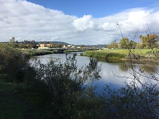
Arroyo Corte Madera del Presidio is a 4.1-mile-long (6.6 km) year-round stream in southern Marin County, California, United States. This watercourse is also known as Corte Madera Creek, although the actual stream of that name flows into San Francisco Bay further north at Point San Quentin. This watercourse has a catchment basin of about 8 square miles (21 km2) and drains the south-eastern slopes of Mount Tamalpais and much of the area in and around the town of Mill Valley; this stream discharges to Richardson Bay.

Nicasio Creek is an 11.9-mile-long (19.2 km) stream in Marin County, California, United States and is the primary tributary of Lagunitas Creek, which flows, in turn, into Tomales Bay, and the Pacific Ocean. The Nicasio Reservoir, formed in 1961 by Seeger Dam, is located on this stream.

San Gregorio Creek is a river in San Mateo County, California. Its tributaries originate on the western ridges of the Santa Cruz Mountains whence it courses southwest through steep forested canyons. The San Gregorio Creek mainstem begins at the confluence of Alpine and La Honda Creeks, whence it flows 12 miles (19 km) through rolling grasslands and pasturelands until it meets the Pacific Ocean at San Gregorio State Beach. It traverses the small unincorporated communities of La Honda, San Gregorio, Redwood Terrace and Sky Londa.
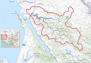
Pescadero Creek is a major stream in Santa Cruz and San Mateo counties in California, United States. At 26.6 miles (42.8 km), it is the longest stream in San Mateo County and flows all year from springs in the Santa Cruz Mountains. Its source is at 1,880 feet (570 m) above sea level on the western edge of Castle Rock State Park, with additional headwaters in Portola Redwoods State Park, and its course traverses Pescadero Creek County Park and San Mateo County Memorial Park before entering Pescadero Marsh Natural Preserve at Pescadero State Beach and thence to the Pacific Ocean 14.4 miles (23 km) south of Half Moon Bay.
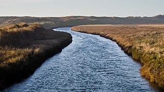
Walker Creek is a northwest-flowing stream in western Marin County, California, United States. It originates at the confluence of Salmon Creek and Arroyo Sausal, and empties into Tomales Bay south of Dillon Beach, California.
SPAWN, the Salmon Protection and Watershed Network, is a project of the Turtle Island Restoration Network (TIRN), a United States 501(c)(3) nonprofit environmental organization.

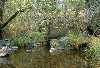
San Vicente Creek is a 9.3-mile-long (15.0 km) northern California coastal stream which flows entirely within Santa Cruz County. It flows from the Santa Cruz Mountains to the Pacific Ocean.
Sonoma Water, formerly known as the Sonoma County Water Agency, maintains a water transmission system that provides naturally filtered Russian River water to more than 600,000 residents in portions of Sonoma County, California and Marin County, California. The Water Agency is a water wholesaler that sells potable water to nine cities and special districts that in turn sell drinking water to their residents. These cities and special districts are: the City of Santa Rosa, Rohnert Park, Cotati, Petaluma, Sonoma, the Town of Windsor, Valley of the Moon Water District, Marin Municipal Water District, and North Marin Water District.
The Marin Municipal Water District is the government agency that provides drinking water to southern and central Marin County, California. Chartered in 1912, it became California's first municipal water district. It serves 191,000 customers in a 147-square-mile (380 km2) area that includes ten towns and cities.

Corte Madera Creek is a short stream which flows southeast for 4.5 miles (7.2 km) in Marin County, California. Corte Madera Creek is formed by the confluence of San Anselmo Creek and Ross Creek in Ross and entering a tidal marsh at Kentfield before connecting to San Francisco Bay near Corte Madera.
San Anselmo Creek is an eastward-flowing stream that begins on the eastern flank of Pine Mountain in the Marin Hills of Marin County, California. At its confluence with Ross Creek, it becomes Corte Madera Creek.
Cascade Creek is a stream that flows south then southeast from its source on White Hill to its confluence with San Anselmo Creek just west of Fairfax in Marin County, California.
Chileno Creek is a stream in western Marin County, California, United States. It originates west of Petaluma, California at 220-acre Laguna Lake which straddles Marin and Sonoma Counties, from which it flows west 6.25 kilometres (3.88 mi) before joining Walker Creek, a tributary of Tomales Bay.
Illabot Creek is a designated National Wild and Scenic River in Northern Washington which provides a spawning and rearing habitat for summer and fall chinook, coho, chum and pink salmon; as well as steelhead and bull trout. The creek is in the Skagit River watershed. Puget Sound Chinook, steelhead and bull trout are listed under the Endangered Species Act. Illabot Creek also supports the highest density of chum and pink salmon in the Skagit River watershed. The creek area also provides habitat for wintering bald eagles that are attracted to the salmon, part of one of the largest concentration of wintering bald eagles in the continental United States.

Old Mill Creek is a 2.3-mile-long (3.7 km) year-round stream in southern Marin County, California, United States. Old Mill Creek is a tributary to Arroyo Corte Madera del Presidio, which, in turn, flows to Richardson Bay at Mill Valley's municipal Bayfront Park and 106 acres (0.43 km2) Bothin Marsh.
References
- ↑ "Watershed Alliance of Marin - Mission". watermarin.org. Retrieved 2014-12-01.
- ↑ "New Plan to Save Marin's Coho Salmon | NBC Bay Area". nbcbayarea.com. Retrieved 2014-12-01.
- ↑ "Salmon Advocates Escalate Pressure on Marin County To Stop Attempts to Weaken Salmon Protection | Mill Valley, CA Patch". patch.com. Retrieved 2014-12-01.
- ↑ "Salmon Advocates Escalate Pressure on Marin County To Stop Weakening Salmon Protection : Indybay". indybay.org. Retrieved 2014-12-01.
- ↑ "Muir Woods coho salmon vanish, fanning fears of extinction - SFGate". sfgate.com. Retrieved 2014-12-01.