
Deschutes County is one of the 36 counties in the U.S. state of Oregon. As of the 2020 census, the population was 198,253. The county seat is Bend. The county was created in 1916 out of part of Crook County and was named for the Deschutes River, which itself was named by French-Canadian trappers of the early 19th century. It is the political and economic hub of Central Oregon. Deschutes comprises the Bend, Oregon Metropolitan Statistical Area. Deschutes is Oregon's fastest-growing and most recently formed county.

Bend is a city in and the county seat of Deschutes County, Oregon, United States. It is the principal city of the Bend Metropolitan Statistical Area. Bend is Central Oregon's most populous city, with a population of 99,178 at the time of the 2020 U.S. Census, up from 76,693 at the time of the 2010 U.S. Census, and 52,029 at the 2000 census. The Bend metro population was 198,253 as of the 2020 census, making it the 6th most populous city in Oregon. It is the fifth largest metropolitan area in Oregon.
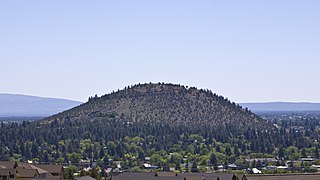
Pilot Butte is a lava dome that was created from an extinct volcano located in Bend, Oregon. It is a cinder cone butte which rises nearly 500 feet (150 m) above the surrounding plains. Bend is one of six cities in the United States to have a volcano within its boundaries. The other examples are Mount Tabor in Portland, Oregon, Jackson Volcano in Jackson, Mississippi, Diamond Head in Honolulu, Glassford Hill in Prescott Valley and Pilot Knob in Austin, Texas.

Central Oregon is a geographic region in the U.S. state of Oregon and is traditionally considered to be made up of Deschutes, Jefferson, and Crook counties. Other definitions include larger areas, often encompassing areas to the north towards the Columbia River, eastward towards Burns, or south towards Klamath Falls. These three counties have a combined population of 200,431 as of the 2010 census, with Deschutes the largest of the three counties, having approximately four times the population of the other two counties combined. As of 2015, the most populous city in the region is Bend, with an estimated 87,014 residents. As defined by the three county definition, Central Oregon covers 7,833 square miles (20,290 km2) of land. Central Oregon has had 3 record tourism years beginning in 2012. Over 2.2 million people visited Central Oregon in 2012 and again in 2013.

Tumalo State Park is a well-developed state park in Deschutes County, Oregon, United States. Established in 1954, the park is located northwest of the city of Bend and along the Deschutes River at a site home to many bird species. The park is popular for picnics, swimming, fishing, hiking, and camping, and is open year-round.

Chandler State Wayside is a state park in south-central Oregon in the United States. It is named in honor of Solomon and Hattie Chandler, who donated the land for the park. The park covers 85 acres (34 ha) of pine forest along a creek. The park provides restrooms and other basic facilities to accommodate the traveling public. Chandler State Wayside is administered by the Oregon Parks and Recreation Department.

The Deschutes River State Recreation Area is a park at the confluence of the Deschutes and Columbia rivers in the U.S. state of Oregon. It is a few miles east of The Dalles. The 35.1-acre (14.2 ha) park offers opportunities for camping, fishing, hiking, mountain biking, and equestrian trail riding.

Collier Memorial State Park is a state park in southern Oregon. The park is operated and maintained by the Oregon Parks and Recreation Department. It is located on U.S. Highway 97, approximately 30 miles (48 km) north of Klamath Falls and 105 miles (169 km) south of Bend. The park covers 146 acres (59 ha) along the Williamson River.

The Eastern Cascades Slopes and Foothills ecoregion is a Level III ecoregion designated by the United States Environmental Protection Agency (EPA) in the U.S. states of Oregon, Washington, and California. In the rain shadow of the Cascade Range, the eastern side of the mountains experiences greater temperature extremes and receives less precipitation than the west side. Open forests of ponderosa pine and some lodgepole pine distinguish this region from the Cascades ecoregion, where hemlock and fir forests are more common, and from the lower, drier ecoregions to the east, where shrubs and grasslands are predominant. The vegetation is adapted to the prevailing dry, continental climate and frequent wildfire. Volcanic cones and buttes are common in much of the region.

Booth State Scenic Corridor is a state park in the U.S. state of Oregon, administered by the Oregon Parks and Recreation Department.

Cline Falls State Scenic Viewpoint is a state park near Redmond, Oregon, United States. It is located on the Deschutes River. The park covers 9 acres (36,000 m2). It is administered by the Oregon Parks and Recreation Department.

The Ochoco Mountains are a mountain range in central Oregon in the United States, located at the western end of the Blue Mountains. They were formed when Permian, Triassic, and Jurassic rocks were slowly uplifted by volcanic eruptions to form the Clarno Formation. Today, the highest point in the range is Lookout Mountain. The dominant vegetation on the west side of the range is old-growth ponderosa pine; on the east side, western juniper is common. The western area of the mountains is administered by the Ochoco National Forest, while the southeastern section is part of the Malheur National Forest. The Ochoco Mountains are used for hiking, camping, bird watching, rockhounding, and hunting, as well as cross-country skiing in the winter.

Wickiup Reservoir is the second-largest reservoir in the U.S. state of Oregon. It is located 60 miles (97 km) southwest of Bend, and is the largest of the Cascade Lakes. Wickiup Reservoir is close to the Twin Lakes, Davis Lake, Crane Prairie Reservoir, Cultus Lake, and Little Cultus Lake. The reservoir is located within the Deschutes National Forest and the Fort Rock Ranger District, near the Cascade Lakes Scenic Byway.

The Pine Tavern is a restaurant in Bend, Oregon, United States. Opened in 1936, the restaurant is located in downtown Bend and is one of the city's best known landmarks. The main dining room was built around two large ponderosa pine trees for which the restaurant is named. Both the main dining room and the restaurant's outdoor garden dining area overlook the Deschutes River. Today, the Pine Tavern is the oldest restaurant in the city of Bend.

Elliott Corbett Memorial State Recreation Site is a state park along the south shore of Blue Lake Crater in Jefferson County, Oregon, United States. The park is named in honor of Elliott R. Corbett II, who was killed while serving in the United States Army during World War II. It includes 63 acres (25 ha) of wilderness land with very few park facilities. Corbett State Park is administered by the Oregon Parks and Recreation Department.

The Fall River is a tributary of the Deschutes River in the Deschutes National Forest in Deschutes County, Oregon, United States. The source is a spring approximately 2 miles (3 km) northwest of Pringle Falls. The river flows to the northeast and is about 12 miles (19 km) long. Fly fishing is permitted.

Redmond–Bend Juniper State Scenic Corridor is a collection of ten unimproved land parcels administered for the Oregon Parks and Recreation Department. The parcels are located along U.S. Route 97 between Bend and Redmond, Oregon, United States. It is named for the large western juniper trees found on the parcels. The scenic corridor is completely undeveloped with no trails or park facilities of any kind.

Sisters State Park is a state park located at the southeast side of the town of Sisters in Deschutes County, Oregon, United States. The park property is bisected by U.S. Route 20 and Oregon Route 126, creating three separate parcels. The park covers 28 acres (11 ha) of undeveloped forest land along Whychus Creek. It is adjacent to two developed city parks that were once part of the state park. Sisters State Park is administered by the Oregon Parks and Recreation Department.

The Cline Buttes are mountains with volcanic origins that form three dome-shaped peaks located in Deschutes County in central Oregon. They are some of the eastern foothills of the Cascade Range. Situated on land administered by the Bureau of Land Management, the buttes are flanked on the east and west sides by two separate sections of the Eagle Crest Resort. On the highest summit, there is a Federal Aviation Administration site with an aircraft navigation beacon. The mountains have several hiking trails as well as a number of popular mountain bike routes.

Cline Falls is a 20 ft-high (6.1 m) segmented steep cascade waterfall on the Deschutes River. It is approximately 4 miles (6.4 km) west of Redmond, Oregon, United States. The waterfall is named for Cass A. Cline, who owned the land adjacent to the falls in the early 20th century. The falls occur just north of the point where Oregon Route 126 crosses the Deschutes River. The riparian area around Cline Falls provides habitat for a variety of fish and wildlife species.


