
Medford is a city in and the county seat of Jackson County, Oregon, in the United States. As of the 2020 United States Census on April 1, 2020, the city had a total population of 85,824 and a metropolitan area population of 223,259, making the Medford MSA the fourth largest metro area in Oregon. The city was named in 1883 by David Loring, civil engineer and right-of-way agent for the Oregon and California Railroad, after Medford, Massachusetts, which was near Loring's hometown of Concord, Massachusetts. Medford is near the middle ford of Bear Creek.
The California Department of Parks and Recreation, more commonly known as California State Parks, manages the California state parks system. The system administers 279 separate park units on 1.4 million acres (570,000 ha), with over 280 miles (450 km) of coastline; 625 miles (1,006 km) of lake and river frontage; nearly 15,000 campsites; and 3,000 miles (4,800 km) of hiking, biking, and equestrian trails. Headquartered in Sacramento, park administration is divided into 21 districts. The California State Parks system is the largest state park system in the United States.

Oswald West State Park is part of the state park system of the U.S. state of Oregon. It is located about 10 miles (16 km) south of the city of Cannon Beach, adjacent to Arch Cape, on the Pacific Ocean. The park covers 2,448 acres (9.91 km2), with many miles of hiking trails both inside the park grounds and linking to other parks and landmarks beyond.

The Depoe Bay Whale Watching Center, also known as the Depoe Bay Ocean Wayside, is an Oregon State Parks-staffed visitor center in Depoe Bay, Oregon, U.S. to help visitors observe whale migration and provide information about whales and other marine mammals, including history, economics, and their environmental and ecological influences. The wayside provides a sheltered platform from which to view the ocean. First established as a wayside parking area on the Oregon Coast Highway in 1930, the wayside building was built in 1956 as a restroom facility for the popular spot. It is located just to the north of the Depoe Bay Bridge, also on the National Register.

Chandler State Wayside is a state park in south-central Oregon in the United States. It is named in honor of Solomon and Hattie Chandler, who donated the land for the park. The park covers 85 acres (34 ha) of pine forest along a creek. The park provides restrooms and other basic facilities to accommodate the traveling public. Chandler State Wayside is administered by the Oregon Parks and Recreation Department.

Sheridan State Scenic Corridor is a state park in the Columbia River Gorge, west of Cascade Locks, Oregon. The 11-acre (4.5 ha) property, containing an old-growth forest, is located on the south side of Interstate 84 at approximately milepoint 42.5, and was not accessible by motor vehicle since I-84 was built in 1960. However, with the opening of the Eagle Creek-Cascade Locks segment of the Historic Columbia River Highway State Trail in 1998, it has become easily accessible by foot or bicycle. The park is on a triangular lot, surrounded by I-84 and the Mount Hood National Forest.

Erratic Rock State Natural Site is a state park in the Willamette Valley of Oregon, United States. Featuring a 40-short-ton (36 t) glacial erratic from the Missoula Floods, the small park sits atop a foothill of the Northern Oregon Coast Range in Yamhill County between Sheridan and McMinnville off Oregon Route 18. The day use only park is owned and maintained by the Oregon Parks and Recreation Department.

Dyer State Wayside, a rest stop with picnic tables and public toilets, lies about 10 miles (16 km) south of Condon, along Oregon Route 19. It occupies 0.6 acres (0.24 ha) in a narrow canyon along a branch of Thirty Mile Creek at the mouth of Ramsey Canyon.

Alderwood State Wayside is a state park on Oregon Route 36 in the U.S. state of Oregon. Administered by the Oregon Parks and Recreation Department, the day-use wayside covers about 76 acres (31 ha). It is open year-round and attracts about 45,000 visitors annually.

Booth State Scenic Corridor is a state park in the U.S. state of Oregon, administered by the Oregon Parks and Recreation Department.

Cline Falls State Scenic Viewpoint is a state park near Redmond, Oregon, United States. It is located on the Deschutes River. The park covers 9 acres (36,000 m2). It is administered by the Oregon Parks and Recreation Department.

D River State Recreation Site is a state park in the U.S. state of Oregon, administered by the Oregon Parks and Recreation Department. It is a sandy beach of the Pacific Ocean within central Lincoln City along the length of the 120-foot (37 m) long D River, one of the world's shortest rivers.

Ellmaker State Wayside is a state park in the U.S. state of Oregon, administered by the Oregon Parks and Recreation Department. It is located on U.S. Route 20 approximately 1 mile (1.6 km) north of the community of Burnt Woods.
Hoffman Memorial State Wayside is a state park in the U.S. state of Oregon, administered by the Oregon Parks and Recreation Department.

Koberg Beach State Recreation Site is a state park in Hood River County, Oregon United States, administered by the Oregon Parks and Recreation Department. The park offers a wayside rest area for west bound traffic on Interstate 84.
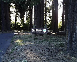
Maud Williamson State Recreation Site is a state park in Yamhill County, Oregon, United States, administered by the Oregon Parks and Recreation Department. The park is located at the intersection of Oregon Route 221 and Oregon Route 153 near Wheatland. The park entrance is across from Wheatland Road, which leads to the Wheatland Ferry.

Red Bridge State Wayside is a state park in the U.S. state of Oregon, administered by the Oregon Parks and Recreation Department.

Tub Springs State Wayside is a state park in the U.S. state of Oregon, administered by the Oregon Parks and Recreation Department.

Washburne State Wayside is a state park 4 miles (6 km) northwest of Junction City, in the U.S. state of Oregon. Administered by the Oregon Parks and Recreation Department, the wayside serves as a rest stop for travelers on Oregon Route 99W and interpretive center for the Applegate Trail. The state bought the land for the park in 1926 from William C. and Mae E. Washburne. It lies on the border between Lane and Benton counties.

Redmond–Bend Juniper State Scenic Corridor is a collection of ten unimproved land parcels administered for the Oregon Parks and Recreation Department. The parcels are located along U.S. Route 97 between Bend and Redmond, Oregon, United States. It is named for the large western juniper trees found on the parcels. The scenic corridor is completely undeveloped with no trails or park facilities of any kind.

