
Champoeg is a former town in the U.S. state of Oregon. Now a ghost town, it was an important settlement in the Willamette Valley in the early 1840s. Located halfway between Oregon City and Salem, it was the site of the first provisional government of the Oregon Country.

Spencer Spit State Park is a public recreation area ran under the Washington State Parks. It covers one hundred and thirty-eight acres (56 ha) on the eastern shore of Lopez Island in San Juan County, Washington. It overlooks the Strait of Juan de Fuca. The state park features two sand spits that enclose a salt chuck lagoon that provides a migratory stop for waterfowl, including Bonaparte's gulls. Other local fauna include great blue herons and kingfishers.

The Wheatland Ferry is a cable ferry that connects Marion County and Yamhill County across the Willamette River in the U.S. state of Oregon. The ferry travels approximately 580 feet across the river, depending on the height of the river, and is powered by two electric motors connected to an on-board diesel generator. The ferry is supported by two steel cables, one under water on the downriver side, and one overhead on the upriver side. The ferry also uses the overhead cable for steering.
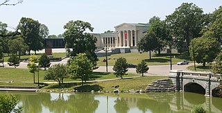
Delaware Park–Front Park System is a historic park system and national historic district in the northern and western sections of Buffalo in Erie County, New York. The park system was designed by Frederick Law Olmsted and Calvert Vaux and developed between 1868 and 1876.

Yaquina Bay State Recreation Site, established in 1948, is a coastal state park in west-central Lincoln County, Oregon, United States, in the city of Newport. It is administered by the Oregon Parks and Recreation Department, and located at the north end of Yaquina Bay near its outlet to the Pacific Ocean. The site includes picnic facilities, beach access, a fisherman's memorial shrine, a forested bluff and the historic Yaquina Bay Lighthouse.
Carnifex Ferry Battlefield State Park is an American Civil War battle site that commemorates the Battle of Carnifex Ferry. It is located on the rim of the Gauley River Canyon near Summersville, a town in Nicholas County, West Virginia. The 156-acre (0.63 km2) park features Patterson House Museum, three views of the Gauley River, hiking trails and picnic facilities. It is one of the oldest state parks in the United States. A Civil War re-enactment takes place on a weekend after Labor Day. As Carnifex Ferry State Park, it was listed on the National Register of Historic Places in 1974.

Oregon Route 153 is an Oregon state highway running from OR 18 in Bellevue to OR 221 near Hopewell. OR 153 is known as the Bellevue-Hopewell Highway No. 153. It is 14.34 miles (23.08 km) long and runs east–west, entirely within Yamhill County.
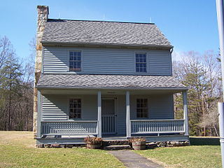
Fort Yamhill was an American military fortification in the state of Oregon. Built in 1856 in the Oregon Territory, it remained an active post until 1866. The Army outpost was used to provide a presence next to the Grand Ronde Agency Coastal Reservation. Several officers stationed at the United States Army post prior to the American Civil War would later serve as generals in that war.
Historic ferries in Oregon are water transport ferries that operated in Oregon Country, Oregon Territory, and the state of Oregon, United States. These ferries allowed people to cross bodies of water, mainly rivers such as the Willamette in the Willamette Valley, and the Columbia, in order to transport goods, move people, and further communications until permanent bridges were built to allow faster crossing of the water. The early ferries were used by wagons and pedestrians, while later ones transported trains and then automobiles. Oregon has a few automobile ferries still in operation.

The Tryon Creek State Natural Area is a state park located primarily in Portland, in the U.S. state of Oregon. It is the only Oregon state park within a major metropolitan area. The 645-acre (261 ha) park lies between Boones Ferry Road and Terwilliger Boulevard in southwest Portland in Multnomah County and northern Lake Oswego in Clackamas County and is bisected from north to south by Tryon Creek. To the north, the park abuts the Lewis & Clark Law School campus.

Tumalo State Park is a well-developed state park in Deschutes County, Oregon, United States. Established in 1954, the park is located northwest of the city of Bend and along the Deschutes River at a site home to many bird species. The park is popular for picnics, swimming, fishing, hiking, and camping, and is open year-round.
Sarah Helmick State Recreation Site, also known as Helmick Park, is a state park located south of Monmouth, in Polk County, Oregon, United States. It is located on the floodplain of the Luckiamute River and is forested by Bigleaf Maple, Douglas-fir, and Black Cottonwood trees, among other varieties. The park is named for Sarah Helmick, a pioneer to Oregon in 1845 who donated the original land. Sarah Helmick State Recreation Site is the first state park established in Oregon. It was listed on the National Register of Historic Places in 2022.

Wheatland is an unincorporated community in Yamhill County, Oregon, United States. It is near the Willamette River where the Wheatland Ferry takes traffic across the river into Marion County. It is in the Pacific Time Zone.

Willamette Mission State Park is a state park in the U.S. state of Oregon, located about four miles (6 km) north of Keizer adjacent to the Wheatland Ferry and east of the Willamette River. It includes Willamette Station Site, Methodist Mission in Oregon, which is listed by the National Register of Historic Places.

Collier Memorial State Park is a state park in southern Oregon. The park is operated and maintained by the Oregon Parks and Recreation Department. It is located on U.S. Highway 97, approximately 30 miles (48 km) north of Klamath Falls and 105 miles (169 km) south of Bend. The park covers 146 acres (59 ha) along the Williamson River.

Benson State Recreation Area is a state park in the U.S. state of Oregon, administered by the Oregon Parks and Recreation Department.
Holman State Wayside is a state park in Polk County, Oregon, United States, on Oregon Route 22 at the foot of the Eola Hills near the community of Eola. The wayside is administered by the Oregon Parks and Recreation Department but was closed to vehicular traffic in 2007 because of ongoing problems with criminal activity.

Manhattan Beach State Recreation Site is a state park in the U.S. state of Oregon. Administered by the Oregon Parks and Recreation Department, the park is open to the public and is fee-free. Amenities at the park, which is 2 miles (3 km) north of Rockaway Beach along U.S. Route 101, include picnicking, fishing, and a Pacific Ocean beach.

Mark Twain State Park is a public recreation area encompassing 2,775 acres (1,123 ha) on Mark Twain Lake in Monroe County, Missouri. The state park offers water recreation, hiking trails, and campgrounds. It is adjacent to the Mark Twain Birthplace State Historic Site.


