The Willamette River is a major tributary of the Columbia River, accounting for 12 to 15 percent of the Columbia's flow. The Willamette's main stem is 187 miles (301 km) long, lying entirely in northwestern Oregon in the United States. Flowing northward between the Oregon Coast Range and the Cascade Range, the river and its tributaries form the Willamette Valley, a basin that contains two-thirds of Oregon's population, including the state capital, Salem, and the state's largest city, Portland, which surrounds the Willamette's mouth at the Columbia.

Yamhill County is one of the 36 counties in the U.S. state of Oregon. As of the 2020 census, the population was 107,722. The county seat is McMinnville. Yamhill County was named after the Yamhelas, members of the Kalapuya Tribe.

A cable ferry is a ferry that is guided across a river or large body of water by cables connected to both shores. Early cable ferries often used either rope or steel chains, with the latter resulting in the alternative name of chain ferry. Both of these were largely replaced by wire cable by the late 19th century.

Oregon Route 99E Business is a business route through Salem, Oregon for Oregon Route 99E, which bypasses downtown via Interstate 5 (I-5). A portion of this highway was originally planned to be a freeway, signed as Interstate 305; however the proposed freeway was cancelled after community opposition.

Oregon Route 221 is an Oregon state highway which runs between the city of Salem, Oregon and the city of Dayton, Oregon, roughly along the western shore of the Willamette River. It is known as the Salem-Dayton Highway No. 150, and is 21 miles (34 km) long. It lies in Yamhill and Polk Counties.

The Buena Vista Ferry connects Marion County and Polk County across the Willamette River in the U.S. state of Oregon. It is located a few miles south of Independence, near the community of Buena Vista. The river is approximately 720 feet wide at the crossing. The cable ferry has a capacity of six vehicles.
The Canby Ferry is a cable ferry in the U.S. state of Oregon that connects Canby, and Wilsonville/Stafford in Clackamas County across the Willamette River. The service has been in operation since 1914, except from 1946 to 1953. The specific vessel used has been replaced and updated several times, most recently in 1997. It is one of three remaining ferries on the Willamette River.

Oregon Route 153 is an Oregon state highway running from OR 18 in Bellevue to OR 221 near Hopewell. OR 153 is known as the Bellevue-Hopewell Highway No. 153. It is 14.34 miles (23.08 km) long and runs east–west, entirely within Yamhill County.

Boones Ferry was a cable ferry which crossed the Willamette River near present-day Wilsonville, Oregon, United States, from 1847 to 1954. It was part of a major land-based thoroughfare in pioneer times linking fledgling Portland with the pre-territorial government at Champoeg, and later Salem. It was eventually made obsolete by the Boone Bridge on Interstate 5.
Historic ferries in Oregon are water transport ferries that operated in Oregon Country, Oregon Territory, and the state of Oregon, United States. These ferries allowed people to cross bodies of water, mainly rivers such as the Willamette in the Willamette Valley, and the Columbia, in order to transport goods, move people, and further communications until permanent bridges were built to allow faster crossing of the water. The early ferries were used by wagons and pedestrians, while later ones transported trains and then automobiles. Oregon has a few automobile ferries still in operation.

Boone Bridge is a steel girder highway bridge over the Willamette River at Wilsonville, Oregon, in the United States. Built in 1954, it crosses the river to the Charbonneau section of Wilsonville, carrying Interstate 5 into the open Willamette Valley from the Portland metropolitan area. Maintained by the Oregon Department of Transportation, the 1,111-foot-long (339 m) bridge has three travel lanes in each direction. To the west is the site of the former Boone's Ferry, which the bridge replaced.

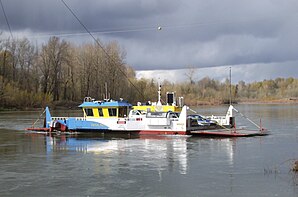
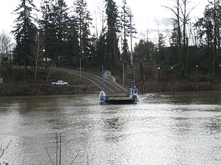
Wheatland is an unincorporated community in Yamhill County, Oregon, United States. It is near the Willamette River where the Wheatland Ferry takes traffic across the river into Marion County. Its elevation is 118 feet (36 m); it is in the Pacific Time Zone.
Valley Junction is an unincorporated community in Polk County, Oregon, United States. It is located at the junction of Oregon Route 18 and Oregon Route 22, on the South Yamhill River east of Grand Ronde. A now-abandoned section of the Willamina and Grand Ronde Railway short line passed through Valley Junction. The Fort Yamhill State Heritage Area and Spirit Mountain Casino are nearby.
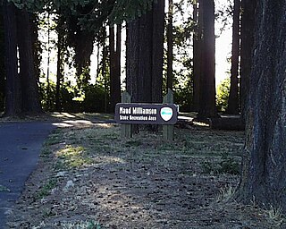
Maud Williamson State Recreation Site is a state park in Yamhill County, Oregon, United States, administered by the Oregon Parks and Recreation Department. The park is located at the intersection of Oregon Route 221 and Oregon Route 153 near Wheatland. The park entrance is across from Wheatland Road, which leads to the Wheatland Ferry.

The Marion Street Bridge is an automobile bridge located in Salem, Oregon, United States. It spans the Willamette River to connect Salem and West Salem, and acts as a conduit for Oregon Route 22. The bridge carries vehicular traffic one way westbound. Traffic includes two lanes that flow onto the bridge from Marion Street, vehicles turning right from Commercial Street, and traffic from a quarter-loop on-ramp from Front Street that was added in 1981. Construction began in December 1952 and the bridge opened in 1954, after taking nearly three years to complete. The bridge was built to complement the Center Street Bridge, which switched from two-way traffic to eastbound-only, later expanding to four lanes in 1982. At the time of its opening, the Marion Street Bridge was the longest bridge of its type west of the Mississippi River.

The Multnomah was one of the first steamboats to operate on the Willamette and Yamhill rivers. This vessel should not be confused with the Multnomah, a steamboat built in Portland, Oregon in 1885, which was larger and of a much different design.

The Willamette River is a 187-mile (301 km) tributary of the Columbia River in the U.S. state of Oregon. The upper tributaries of the Willamette originate in mountains south and southeast of the twin cities of Eugene and Springfield. Formed by the confluence of the Middle Fork Willamette River and Coast Fork Willamette River near Springfield, the main stem meanders generally north from source to mouth. The river's two most significant course deviations occur at Newberg, where the stream turns sharply east, and about 18 miles (29 km) downriver from Newberg, where it turns north again. Near its mouth, the river splits into two channels that flow around Sauvie Island. The main channel enters the Columbia about 101 miles (163 km) from the larger stream's mouth on the Pacific Ocean, and the smaller Multnomah Channel enters the Columbia about 14.5 miles (23.3 km) further downstream near St. Helens in Columbia County.

The Willamette Valley is a 150-mile (240 km) long valley in Oregon, in the Pacific Northwest region of the United States. The Willamette River flows the entire length of the valley and is surrounded by mountains on three sides: the Cascade Range to the east, the Oregon Coast Range to the west, and the Calapooya Mountains to the south.

Elwood was a sternwheel steamboat which was built to operate on the Willamette River, in Oregon, but which later operated on the Lewis River in Washington, the Stikine River in Canada, and on Puget Sound. The name of this vessel is sometimes seen spelled "Ellwood". Elwood is probably best known for an incident in 1893, when it was approaching the Madison Street Bridge over the Willamette River in Portland, Oregon. The bridge swung open to allow the steamer to pass. However, a streetcar coming in from the east end of the bridge failed to notice the bridge was open, and ran off into the river in the Madison Street Bridge disaster.

The Yamhill River lock and dam was completed in 1900. It was built near Lafayette, Oregon, to allow better river transport on the Yamhill River from Dayton, to McMinnville, Oregon. While the Corps of Engineers had recommended against construction of the lock, it was built anyway, largely as a result of political effort by the backers of the project. For almost forty years prior to the lock construction there had been efforts made to construct a lock and dam on the Yamhill River.