The Willamette River is a major tributary of the Columbia River, accounting for 12 to 15 percent of the Columbia's flow. The Willamette's main stem is 187 miles (301 km) long, lying entirely in northwestern Oregon in the United States. Flowing northward between the Oregon Coast Range and the Cascade Range, the river and its tributaries form the Willamette Valley, a basin that contains two-thirds of Oregon's population, including the state capital, Salem, and the state's largest city, Portland, which surrounds the Willamette's mouth at the Columbia.
Polk County is one of the 36 counties in the U.S. state of Oregon. As of the 2020 census, the population was 87,433. The county seat is Dallas. The county is named for James Knox Polk, the 11th president of the United States.

Buena Vista is a city in Marion County, Georgia, United States. It is part of the Columbus, Georgia-Alabama Metropolitan Statistical Area. The population was 1,585 at the 2020 census, down from 2,173 in 2010. Formerly known as "Pea Ridge", the city changed its name to Buena Vista in honor of Zachary Taylor's victory in the Mexican–American War. The city is the county seat of Marion County. It is the birthplace of baseball legend Josh Gibson and Medal of Honor recipient Luther H. Story.

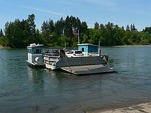
The Wheatland Ferry is a cable ferry that connects Marion County and Yamhill County across the Willamette River in the U.S. state of Oregon. The ferry travels approximately 580 feet across the river, depending on the height of the river, and is powered by two electric motors connected to an on-board diesel generator. The ferry is supported by two steel cables, one under water on the downriver side, and one overhead on the upriver side. The ferry also uses the overhead cable for steering.
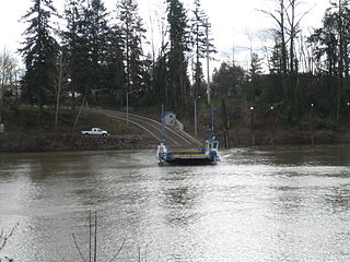
The Canby Ferry is a cable ferry in the U.S. state of Oregon that connects Canby, and Wilsonville/Stafford in Clackamas County across the Willamette River. The service has been in operation since 1914, except from 1946 to 1953. The specific vessel used has been replaced and updated several times, most recently in 1997. It is one of three remaining ferries on the Willamette River.

Boones Ferry was a cable ferry which crossed the Willamette River near present-day Wilsonville, Oregon, United States, from 1847 to 1954. It was part of a major land-based thoroughfare in pioneer times linking fledgling Portland with the pre-territorial government at Champoeg, and later Salem. It was eventually made obsolete by the Boone Bridge on Interstate 5.

Gatke Hall is the second-oldest building at Willamette University in Salem, Oregon, United States. A two-story structure, it was originally built in downtown Salem in 1903 across the street from the Marion County Courthouse and served as a post office. The Beaux Arts styled building was moved to the university in 1938 and first served as the home to the law school.
Historic ferries in Oregon are water transport ferries that operated in Oregon Country, Oregon Territory, and the state of Oregon, United States. These ferries allowed people to cross bodies of water, mainly rivers such as the Willamette in the Willamette Valley, and the Columbia, in order to transport goods, move people, and further communications until permanent bridges were built to allow faster crossing of the water. The early ferries were used by wagons and pedestrians, while later ones transported trains and then automobiles. Oregon has a few automobile ferries still in operation.
Buena Vista is an unincorporated community in Polk County, Oregon, United States. It is located on the Willamette River, and is the western landing for the Buena Vista Ferry. It is approximately 7 miles (11 km) south-southeast of Independence.

Wheatland is an unincorporated community in Yamhill County, Oregon, United States. It is near the Willamette River where the Wheatland Ferry takes traffic across the river into Marion County. Its elevation is 118 feet (36 m); it is in the Pacific Time Zone.
Shelton Ditch is an artificial canal in Marion County, Oregon, United States. Built in the mid-19th century, it originates from Mill Creek east of Airport Road in Salem, passes through a corner of the Salem main Post Office property, and along the southern edge of downtown Salem. Shelton Ditch passes by the north side of Pringle Park before emptying into Pringle Creek. After the Mill Race joins Pringle Creek near Salem's city hall, Pringle Creek passes under the Boise Cascade building and empties into the Willamette River next to Riverfront Park across from Minto-Brown Island Park.

The Willamette River is a 187-mile (301 km) tributary of the Columbia River in the U.S. state of Oregon. The upper tributaries of the Willamette originate in mountains south and southeast of the twin cities of Eugene and Springfield. Formed by the confluence of the Middle Fork Willamette River and Coast Fork Willamette River near Springfield, the main stem meanders generally north from source to mouth. The river's two most significant course deviations occur at Newberg, where the stream turns sharply east, and about 18 miles (29 km) downriver from Newberg, where it turns north again. Near its mouth, the river splits into two channels that flow around Sauvie Island. The main channel enters the Columbia about 101 miles (163 km) from the larger stream's mouth on the Pacific Ocean, and the smaller Multnomah Channel enters the Columbia about 14.5 miles (23.3 km) further downstream near St. Helens in Columbia County.

The Willamette Valley is a 150-mile (240 km) long valley in Oregon, in the Pacific Northwest region of the United States. The Willamette River flows the entire length of the valley and is surrounded by mountains on three sides: the Cascade Range to the east, the Oregon Coast Range to the west, and the Calapooya Mountains to the south.

The Valley and Siletz Railroad (VS) is a 40.6-mile (65.3 km) defunct railroad located in Polk and Benton counties in the U.S. state of Oregon.
Burlington is an unincorporated historic community Linn County, in the U.S. state of Oregon. It was located about a mile downriver from Peoria.

A trolley boat is an electrically driven boat on canals and particularly in canal tunnels. It takes its energy like a tram or trolleybus from one or two overhead wires respectively.
Orleans was a city in Linn County, Oregon, United States. It was established around 1850 and destroyed in the Great Flood of 1862. It was not rebuilt. The city was located across the Willamette River from Corvallis. The Orleans cemetery survived because it was built on high ground at 44.5697°N 123.1913°W.

The Truman Wesley Collins Legal Center houses the Willamette University College of Law at Willamette University in Salem, Oregon, United States. Located on Winter Street, just south of the Oregon State Capitol, the facility features classrooms, the law library, administrative offices, and faculty offices. The building also contains a fully functioning trial courtroom used for moot court. It houses Lady Justice, the 12-foot (3.7 m)-tall, 300-pound (140 kg) statue formerly located on the roof of the Marion County Courthouse.

Syracuse was a historic community in Linn County, Oregon, United States. It was located along the Santiam River, about two miles west of Jefferson. Syracuse was the first pioneer settlement in Linn County, predating Albany.