Polk County, Oregon

Last updated

Polk County
Polk County Courthouse, Dallas - DPLA - ffa1635fc98ab0e7cb04ae673a2f690c.jpg
Map of Oregon highlighting Polk County.svg
Location within the U.S. state of Oregon
Oregon in United States.svg
Oregon's location within the U.S.
Coordinates: 44°55′N123°25′W / 44.91°N 123.42°W / 44.91; -123.42
CountryFlag of the United States.svg United States
StateFlag of Oregon.svg  Oregon
FoundedDecember 22, 1845
Named for James K. Polk
Seat Dallas
Largest city Salem (portion)
Area
  Total744 sq mi (1,930 km2)
  Land741 sq mi (1,920 km2)
  Water3.1 sq mi (8 km2)  0.4%
Population
 (2020)
  Total87,433
  Estimate 
(2023)
89,805 Increase2.svg
  Density118/sq mi (46/km2)
Time zone UTC−8 (Pacific)
  Summer (DST) UTC−7 (PDT)
Congressional district 6th
Website www.co.polk.or.us
Map of Polk County Polk County.svg
Map of Polk County

Polk County is one of the 36 counties in the U.S. state of Oregon. As of the 2020 census, the population was 87,433. [1] The county seat is Dallas. [2] The county is named for James Knox Polk, the 11th president of the United States.

Contents

Polk County is part of the Salem, OR Metropolitan Statistical Area, which is also included in the Portland-Vancouver-Salem, OR-WA Combined Statistical Area. It is located in the Willamette Valley.

History

Agricultural field and tree near Perrydale Lone tree near Perrydale Oregon.JPG
Agricultural field and tree near Perrydale

The Oregon Provisional Legislature created Polk County from Yamhill District on December 22, 1845, granting to it the entire southwestern portion of present-day Oregon to the California border. County boundaries were periodically changed to reflect the creation of Benton and Lincoln counties. Many other counties were subsequently carved out of these as settlement spread towards the south, leaving Polk County many counties away from its former border with California.

The first county seat was a settlement on the north side of Rickreall Creek named Cynthian (also known as Cynthia Ann). In 1852 city officials renamed Cynthian to Dallas after Vice President George M. Dallas, vice president (1845–1849) to James Polk. During the 1880s and 1890s, there were a series of unsuccessful efforts to move the county seat to nearby Independence.
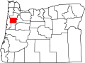
Geography

According to the United States Census Bureau, the county has a total area of 744 square miles (1,930 km2), of which 741 square miles (1,920 km2) is land and 3.1 square miles (8.0 km2) (0.4%) is water. [3]

About two thirds of Polk County, the western part, is forest, mostly of the coniferous and mixed varieties, bordering on temperate rain forest around Laurel Mountain, the wettest place in Oregon.

The eastern half of the county lies in the Willamette Valley. The Willamette River forms the eastern border of the county, separating it from neighboring Marion County.

Adjacent counties

National protected areas

Demographics

Historical population
CensusPop.Note
1860 3,625
1870 4,70129.7%
1880 6,60140.4%
1890 7,85819.0%
1900 9,92326.3%
1910 13,46935.7%
1920 14,1815.3%
1930 16,85818.9%
1940 19,98918.6%
1950 26,31731.7%
1960 26,5230.8%
1970 35,34933.3%
1980 45,20327.9%
1990 49,5419.6%
2000 62,38025.9%
2010 75,40320.9%
2020 87,43316.0%
2023 (est.)89,805 [4] 2.7%
U.S. Decennial Census [5]
1790–1960 [6] 1900–1990 [7]
1990–2000 [8] 2010–2020 [1]

2020 census

As of the 2020 census, there were 87,433 people, 30,305 households,. [9] The population density was 101.8 inhabitants per square mile (39.3/km2). There were 30,302 housing units at an average density of 40.9 units per square mile (15.8 units/km2). [10] The racial makeup of the county was 85.9% white, 2.1% American Indian, 1.9% Asian, 0.6% black or African American, 0.3% Pacific islander, 5.4% from other races, and 3.8% from two or more races. Those of Hispanic or Latino origin made up 12.1% of the population. [9] In terms of ancestry, 22.4% were German, 16.4% were English, 10.4% were Irish, and 6.4% were American. [11]

Of the 28,288 households, 32.4% had children under the age of 18 living with them, 54.2% were married couples living together, 10.3% had a female householder with no husband present, 30.9% were non-families, and 23.0% of all households were made up of individuals. The average household size was 2.60 and the average family size was 3.06. The median age was 37.1 years. [9]

The median income for a household in the county was $50,975 and the median income for a family was $61,418. Males had a median income of $46,616 versus $35,371 for females. The per capita income for the county was $24,345. About 8.8% of families and 12.9% of the population were below the poverty line, including 17.2% of those under age 18 and 6.8% of those age 65 or over. [12]

2010 census

As of the 2010 census, there were 75,403 people, 28,288 households, and 19,545 families living in the county. The population density was 102 inhabitants per square mile (39/km2). There were 30,302 housing units at an average density of 41 units per square mile (16 units/km2). The racial makeup of the county was 85.9% White, 0.6% Black or African American, 2.1% Native American, 1.9% Asian, 0.3% Pacific Islander, 5.4% from other races, and 3.8% from two or more races. 12.1% of the population were Hispanic or Latino of any race.

There were 28,288 households in 2010, out of which 32.4% had children under the age of 18 living with them, 54.2% were married couples living together, 10.3% had a female householder with no husband present, and 30.9% were non-families. 23% of all households were made up of individuals, and 9.8% had someone living alone who was 65 years of age or older. The average household size was 2.60 and the average family size was 3.06.

In the county, the population was spread out, with 24.3% under the age of 18 and 14.8% 65 years of age or older. The median age was 37.1 years. For every 100 females, there were 94.8 males. For every 100 females age 18 and over, there were 91.8 males.

As of the 2000 census, the median income for a household in the county was $42,311, and the median income for a family was $50,483. Males had a median income of $36,667 versus $26,272 for females. The per capita income for the county was $19,282. About 6.30% of families and 11.50% of the population were below the poverty line, including 12.50% of those under age 18 and 5.50% of those age 65 or over.

Politics

Though Polk County is located in western Oregon, politically it falls in line with the eastern side of the state. The majority of registered voters who are part of a political party in Polk County, as well as most rural counties in Oregon, are members of the Republican Party. [13]

In the 2012 presidential election, 50.54 percent of Polk County voters voted for Republican Mitt Romney, while 46.21 percent voted for Democrat Barack Obama, and 3.25 percent either voted for a Third Party candidate or wrote in a candidate. [14] These numbers show a shift toward the Republican candidate when compared to the 2008 presidential election, in which 48.92% of Polk County voters voted for Republican John McCain, while 48.43 percent voted for Barack Obama, and 2.64 percent either voted for a Third Party candidate or wrote in a candidate. [15] Obama's 2008 performance was the best by a Democrat since Lyndon Johnson carried the county in 1964; the only other Democrats to ever carry Polk County have been Franklin Roosevelt in 1932 and 1936, Woodrow Wilson in 1912, and William Jennings Bryan in 1896. However, Polk's Republican lean has been thinning in recent years. Republicans managed to win 50% or more of the county's vote only three times since 1992. [16]

Presidential Elections

United States presidential election results for Polk County, Oregon [17]
Year Republican Democratic Third party
No.%No.%No.%
2020 23,73249.14%22,91747.46%1,6423.40%
2016 18,94047.00%16,42040.75%4,93512.25%
2012 17,81950.54%16,29246.21%1,1463.25%
2008 17,71448.92%17,53648.43%9572.64%
2004 19,50854.97%15,48443.63%4971.40%
2000 14,98852.68%11,92141.90%1,5405.41%
1996 11,47845.31%10,94243.20%2,91111.49%
1992 10,08239.36%9,55137.29%5,98123.35%
1988 10,55351.18%9,62646.68%4422.14%
1984 12,67859.15%8,70940.64%450.21%
1980 10,00648.74%7,83338.15%2,69213.11%
1976 8,52848.65%8,14146.44%8614.91%
1972 8,98557.56%5,90837.85%7164.59%
1968 6,99755.66%4,96139.46%6134.88%
1964 4,31937.14%7,29262.71%180.15%
1960 6,70959.38%4,57840.52%110.10%
1956 6,40461.28%4,04738.72%00.00%
1952 6,85069.41%2,98330.23%360.36%
1948 4,32854.02%3,45143.07%2332.91%
1944 3,90453.19%3,31845.20%1181.61%
1940 4,21150.44%4,07748.84%600.72%
1936 2,24634.56%3,69456.85%5588.59%
1932 2,54839.12%3,70556.88%2614.01%
1928 3,24464.44%1,72434.25%661.31%
1924 2,75552.75%1,62131.04%84716.22%
1920 2,70958.97%1,65335.98%2325.05%
1916 2,89947.89%2,84446.98%3115.14%
1912 1,04332.07%1,20136.93%1,00831.00%
1908 1,45651.87%1,11339.65%2388.48%
1904 1,38063.65%52124.03%26712.32%

Economy

The major industries of the county are agriculture, forest products, manufacturing, and education. Polk County has the second-largest area devoted to viticulture in Oregon, at 1,322 acres (5.35 km2). Western Oregon University in Monmouth is a major employer.

Communities

Cities

Census-designated places

Unincorporated communities

Education

K-12 school districts include: [18]

All of Polk County is within the Chemeketa Community College district. [19]

See also

Related Research Articles

<span class="mw-page-title-main">Yamhill County, Oregon</span> County in Oregon, United States

Yamhill County is one of the 36 counties in the U.S. state of Oregon. As of the 2020 census, the population was 107,722. The county seat is McMinnville. Yamhill County was named after the Yamhelas, members of the Kalapuya Tribe.

<span class="mw-page-title-main">Tillamook County, Oregon</span> County in Oregon, United States

Tillamook County is one of the 36 counties in the U.S. state of Oregon. As of the 2020 census, the population was 27,390. The county seat is Tillamook. The county is named for the Tillamook or Killamook people, a Native American tribe who were living in the area in the early 19th century at the time of European American settlement. The county is located within Northwest Oregon.

<span class="mw-page-title-main">Marion County, Oregon</span> County in Oregon, United States

Marion County is one of the 36 counties in the U.S. state of Oregon. The population was 345,920 at the 2020 census, making it the 5th most populous county in Oregon. The county seat is Salem, which is also the state capital of Oregon. The county was originally named the Champooick District, after Champoeg, a meeting place on the Willamette River. On September 3, 1849, the territorial legislature renamed it in honor of Francis Marion, a Continental Army general from South Carolina who served in the American Revolutionary War.

<span class="mw-page-title-main">Malheur County, Oregon</span> County in Oregon, United States

Malheur County is one of the 36 counties in the U.S. state of Oregon. As of the 2020 census, the population was 31,571. Its county seat is Vale, and its largest city is Ontario. The county was named after the Malheur River, which runs through the county. The word "malheur" is French for misfortune or tragedy. Malheur County is included in the Ontario, Oregon Micropolitan Statistical Area, which is also included in the Boise Combined Statistical Area. It is included in the eight-county definition of Eastern Oregon.

<span class="mw-page-title-main">Linn County, Oregon</span> County in Oregon, United States

Linn County is one of the 36 counties in the U.S. state of Oregon. As of the 2020 census, the population was 128,610. The county seat is Albany. The county is named in the honor of Lewis F. Linn, a U.S. Senator from Missouri who advocated the American settlement of the Oregon Country. Linn County comprises the Albany, OR Metropolitan Statistical Area, which is included in the Portland-Vancouver-Salem, OR-WA Combined Statistical Area. It is located in the Willamette Valley. In 2010, the center of population of Oregon was located in Linn County, near the city of Lyons.

<span class="mw-page-title-main">Lincoln County, Oregon</span> County in Oregon, United States

Lincoln County is one of the 36 counties in the U.S. state of Oregon. As of the 2020 census, its population was 50,395. The county seat is Newport. The county is named for Abraham Lincoln, 16th president of the United States.

<span class="mw-page-title-main">Lane County, Oregon</span> County in Oregon, United States

Lane County is one of the 36 counties in the U.S. state of Oregon. As of the 2020 census, the population was 382,971, making it the fourth-most populous county in Oregon. The county seat is Eugene, the state's second most populous city. It is named in honor of Joseph Lane, Oregon's first territorial governor.

<span class="mw-page-title-main">Jefferson County, Oregon</span> County in Oregon, United States

Jefferson County is one of the 36 counties in the U.S. state of Oregon. At the 2020 census, the population was 24,502. The county seat is Madras. The county is named after Mount Jefferson, the second tallest mountain in Oregon.

<span class="mw-page-title-main">Douglas County, Oregon</span> County in Oregon, United States

Douglas County is one of the 36 counties in the U.S. state of Oregon. As of the 2020 census, the population was 111,201. The county seat is Roseburg. The county is named after Stephen A. Douglas, an American politician who supported Oregon statehood. Douglas County comprises the Roseburg, OR Micropolitan Statistical Area. In regards to area, Douglas County is the largest county west of the Oregon Cascades.

<span class="mw-page-title-main">Curry County, Oregon</span> County in Oregon, United States

Curry County is the southwesternmost county in the U.S. state of Oregon located on the South Coast. As of the 2020 census, the population was 23,446. The county seat is Gold Beach. The county is named for George Law Curry, a two-time governor of the Oregon Territory. Curry County includes the Brookings, OR Micropolitan Statistical Area.

<span class="mw-page-title-main">Benton County, Oregon</span> County in Oregon, United States

Benton County is one of the 36 counties in the U.S. state of Oregon. As of the 2020 census, the population was 95,184. Its county seat is Corvallis. The county was named after Thomas Hart Benton, a U.S. Senator who advocated American control over the Oregon Country. Benton County is designated as the Corvallis, OR Metropolitan Statistical Area, which is included in the Portland–Vancouver–Salem, OR–WA Combined Statistical Area. It is in the Willamette Valley.

<span class="mw-page-title-main">Baker County, Oregon</span> County in Oregon, United States

Baker County is one of the 36 counties in the U.S. state of Oregon. As of the 2020 census, the population was 16,668. The county seat and largest city is Baker City. The county was organized on September 22, 1862, when a portion of Wasco County was partitioned off. The new county's area was reduced in 1864 when Union County was partitioned off, and again in 1887 when Malheur County was partitioned off. The county's lines were last adjusted in 1901 when a parcel was added to the county.

<span class="mw-page-title-main">Dallas County, Missouri</span> County in Missouri, United States

Dallas County is a county located in the U.S. state of Missouri. As of the 2010 census, the population was 17,071. Its county seat is Buffalo. The county was organized in 1842 as Niangua County and then renamed in 1844 for George M. Dallas, who served as Vice President under James K. Polk.

<span class="mw-page-title-main">Polk County, Iowa</span> County in Iowa, United States

Polk County is located in the U.S. state of Iowa. As of the 2020 census, the population was 492,401. It is Iowa's most populous county, and home to over 15% of the state's residents. The county seat is Des Moines, which is also the capital city of Iowa. Polk County is included in the Des Moines–West Des Moines, IA Metropolitan Statistical Area.

<span class="mw-page-title-main">Dallas County, Iowa</span> County in Iowa, United States

Dallas County is a county located in the U.S. state of Iowa. As of the 2020 Census, the population was 99,678, making it the seventh-most populous county in Iowa. Between 2010 and 2020, it was the fastest growing county in Iowa and one of the fastest growing in the country. Its county seat is Adel, and its largest city is Waukee. The county was named for George M. Dallas, Vice President of the United States under James K. Polk, the namesake of neighboring Polk County.

<span class="mw-page-title-main">Westfir, Oregon</span> City in Oregon, United States

Westfir is a city in Lane County, Oregon, United States. The population was 253 at the 2010 census. It is located about 40 miles (64 km) southeast of Eugene and about 4 miles (6 km) west of Oakridge in the Willamette National Forest.

<span class="mw-page-title-main">Dallas, Oregon</span> City in Oregon, United States

Dallas is a city and the county seat of Polk County, Oregon, United States. The population was 16,854 at the 2020 census.

<span class="mw-page-title-main">Eola, Oregon</span> Unincorporated community in the state of Oregon, United States

Eola is an unincorporated community in Polk County, Oregon, United States. It lies four miles west of Salem on Oregon Route 22 at the confluence of Rickreall Creek and the Willamette River.

<span class="mw-page-title-main">Independence, Oregon</span> City in Oregon, United States

Independence is a city in Polk County, Oregon, United States, on the west bank of the Willamette River along Oregon Route 51, and east of nearby Monmouth. It is part of the Salem Metropolitan Statistical Area. Thirty square blocks of the oldest part of Independence form the National Register of Historic Places-listed Independence Historic District.

<span class="mw-page-title-main">Rickreall, Oregon</span> Unincorporated community in the state of Oregon, United States

Rickreall is an unincorporated community in Polk County, Oregon, United States. For statistical purposes, the United States Census Bureau has defined Rickreall as a census-designated place (CDP). The census definition of the area may not precisely correspond to local understanding of the area with the same name. The population of the CDP was 76 at the 2020 census. Rickreall is part of the Salem Metropolitan Statistical Area. Rickreall Creek runs along the community's southern edge.

References

  1. 1 2 "State & County QuickFacts". United States Census Bureau. Retrieved May 15, 2023.
  2. "Find a County". National Association of Counties. Retrieved June 7, 2011.
  3. "QuickFacts". United States Census Bureau. Retrieved September 15, 2021.
  4. "Annual Estimates of the Resident Population for Counties: April 1, 2020 to July 1, 2023". United States Census Bureau. Retrieved March 24, 2024.
  5. "U.S. Decennial Census". United States Census Bureau. Retrieved February 28, 2015.
  6. "Historical Census Browser". University of Virginia Library. Retrieved February 28, 2015.
  7. Forstall, Richard L., ed. (March 27, 1995). "Population of Counties by Decennial Census: 1900 to 1990". United States Census Bureau. Retrieved February 28, 2015.
  8. "Census 2000 PHC-T-4. Ranking Tables for Counties: 1990 and 2000" (PDF). United States Census Bureau. April 2, 2001. Archived from the original (PDF) on February 26, 2015. Retrieved February 28, 2015.
  9. 1 2 3 "DP-1 Profile of General Population and Housing Characteristics: 2020 Demographic Profile Data". United States Census Bureau. Archived from the original on February 13, 2020. Retrieved September 15, 2020.
  10. "Population, Housing Units, Area, and Density: 2010 – County". United States Census Bureau. Archived from the original on February 13, 2020. Retrieved February 23, 2016.
  11. "DP02 SELECTED SOCIAL CHARACTERISTICS IN THE UNITED STATES – 2006–2010 American Community Survey 5-Year Estimates". United States Census Bureau. Archived from the original on February 13, 2020. Retrieved February 23, 2016.
  12. "DP03 SELECTED ECONOMIC CHARACTERISTICS – 2006–2010 American Community Survey 5-Year Estimates". United States Census Bureau. Archived from the original on February 13, 2020. Retrieved February 23, 2016.
  13. "Voter Registration by County" (PDF). Oregon Secretary of State. February 2014. p. 1. Retrieved March 20, 2014.
  14. "November 6, 2012, General Election Abstract of Votes: United States President" (PDF). Oregon Secretary of State. Retrieved March 20, 2014.
  15. "November 4, 2008, General Election Abstracts of Votes: United States President" (PDF). Oregon Secretary of State. Retrieved March 20, 2014.
  16. Menendez, Albert J.; The Geography of Presidential Elections in the United States, 1868–2004, pp. 284–285 ISBN   0786422173
  17. Leip, David. "Dave Leip's Atlas of U.S. Presidential Elections". uselectionatlas.org. Retrieved April 11, 2018.
  18. "2020 CENSUS - SCHOOL DISTRICT REFERENCE MAP: Polk County, OR" (PDF). United States Census Bureau. Archived (PDF) from the original on October 9, 2022. Retrieved July 20, 2022.
  19. "Oregon Community Colleges and Community College Districts" (PDF). Oregon Department of Community Colleges & Workforce Development. Archived (PDF) from the original on October 9, 2022. Retrieved July 17, 2022.

Further reading

44°55′N123°25′W / 44.91°N 123.42°W / 44.91; -123.42