Polk County is one of the 36 counties in the U.S. state of Oregon. As of the 2020 census, the population was 87,433. The county seat is Dallas. The county is named for James Knox Polk, the 11th president of the United States.

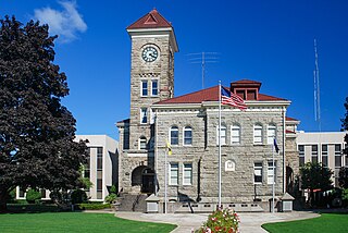
Dallas is a city and the county seat of Polk County, Oregon, United States. The population was 16,854 at the 2020 census.

Sheridan is a city in Yamhill County, Oregon, United States. Platted in the 1860s when it received a post office, the city was incorporated in 1880. A major fire burned much of the city in 1913, and a flood covered much of the city in 1964. The population of the city as of the 2020 Census was 6,100, a decrease from 6,127 at the 2010 census.

Willamina is a city in Polk and Yamhill Counties in the U.S. state of Oregon. The population was 2,239 at the 2020 census.

Ballston is a neighborhood in Arlington County, Virginia. Ballston is located at the western end of the Rosslyn-Ballston corridor. It is a major transportation hub and boasts one of the nation's highest concentrations of scientific research institutes and research and development agencies including the Defense Advanced Research Projects Agency-DARPA, the Office of Naval Research, the Advanced Research Institute of Virginia Tech, the Air Force Office of Scientific Research, and associated engineering, management, and public sector consulting firms. Ballston also contains a section known as Virginia Square and sometimes the area is collectively known as Ballston-Virginia Square.

The South Yamhill River is a tributary of the Yamhill River, approximately 60 miles (97 km) long, in northwest Oregon in the United States. It drains an area of the Northern Oregon Coast Range, as well as part of the Willamette Valley west of the Willamette River.

The Sumpter Valley Railway, or Sumpter Valley Railroad, is a 3 ft narrow gauge heritage railroad located in Baker County, in the U.S. state of Oregon. Built on a right-of-way used by the original railway of the same name, it carries excursion trains on a roughly 5-mile (8.0 km) route between McEwen and Sumpter. The railroad has two steam locomotives and several other pieces of rolling stock. Passenger excursion trains operate on weekends and holidays from Memorial Day through the end of September.

Goshen is an unincorporated community in Lane County, Oregon, United States. It is located at the junction of Oregon Route 58, Oregon Route 99, and Interstate 5.

Pratum is an unincorporated community in Marion County, Oregon, United States. It is located northeast of Salem on Howell Prairie near the Pudding River. Pratum is Latin for "meadow". The community was settled in the late 19th century by a group of Mennonites, many of them of Swiss extraction. A branch of the narrow-gauge Oregonian Railway was built through the area in about 1880, and the station there was called "East Side Junction". The railway was eventually converted to standard gauge, and is still in use today by the Willamette Valley Railway. In 1895, the station was renamed "Enger" by a Mr. Larson, who opened the first store there. "Enger" was confused with Eugene, however, and the name of the station changed to "Pratum" in 1898. Pratum post office was established in 1887, and was originally called "Switzerland", then "Enger" and finally "Pratum" in 1898, matching the railroad station. The post office ran until 1964. Pratum Elementary School, was built in 1928 and is part of the Silver Falls School District, and is still operating.

Whitney is an unincorporated community, also considered a ghost town, in Baker County, Oregon, United States, on Oregon Route 7 southwest of Sumpter. It is on the North Fork Burnt River, near the Blue Mountains and Wallowa-Whitman National Forest.
Rail transportation is an important element of the transportation network in the U.S. state of Oregon. Rail transportation has existed in Oregon in some form since 1855, and the state was a pioneer in development of electric railway systems. While the automobile has displaced many uses of rail in the state, rail remains a key means of moving passengers and freight, both within the state and to points beyond its borders.

Bethel is an unincorporated community in Polk County, Oregon, United States. It sits at the base of the Eola Hills in Plum Valley. Bethel is considered a ghost town as the only remaining structure is a school, now serving as a church. The locale was named by the Rev. Glen O. Burnett for a Church of Christ in Missouri where he had served as pastor. Bethel is a common name for churches as it is a Hebrew word that means "house of god". After traveling with his family on the Oregon Trail, Burnett settled on a Donation Land Claim in 1846. Burnett later rode circuit to the surrounding area, preaching in nearby communities, including Rickreall.

The Dayton, Sheridan and Grande Ronde Railroad (DS&GR) was a 3 ft narrow gauge railroad in Yamhill and Polk counties in the U.S. state of Oregon.

Dolph is an unincorporated community in Tillamook County, Oregon, United States, near the Yamhill County line. It lies at the junction of Oregon Route 22 and Oregon Route 130 between Grande Ronde and Hebo, on the Little Nestucca River. It is within the Siuslaw National Forest in the Northern Oregon Coast Range.
Macleay is an unincorporated community in Marion County, Oregon, United States, about nine miles east of downtown Salem in the Waldo Hills near the Little Pudding River.
Worden is an unincorporated community in Klamath County, Oregon, United States. It is about 14 miles (23 km) south of Klamath Falls and 3 miles (5 km) north of the Oregon–California border on U.S. Route 97.
Airlie is an unincorporated community in Polk County, Oregon, United States.
Crowley is an unincorporated community in Polk County, Oregon, United States. It is located east of Oregon Route 99W, about four miles north of Rickreall.
Suver is an unincorporated community in Polk County, Oregon, United States. It is located about 10 miles north of Corvallis and about 8 miles south of Monmouth, 1 mile east of Oregon Route 99W.
Blalock was an unincorporated community located in the Columbia River Gorge in Gilliam County, Oregon, United States. The town displaced a Native American settlement originally named Táwash. Blalock was located about 7 miles (11 km) west of Arlington on Interstate 84/U.S. Route 30 at the mouth of Blalock Canyon. Blalock is still the name of a station on the Union Pacific Railroad.

