Sheridan, Oregon

Last updated

Sheridan, Oregon
Sheridan Oregon hill.JPG
View of the city looking southwest
Yamhill County Oregon Incorporated and Unincorporated areas Sheridan Highlighted.svg
Location in Oregon
Coordinates: 45°05′46″N123°23′54″W / 45.09611°N 123.39833°W / 45.09611; -123.39833
Country United States
State Oregon
County Yamhill
Incorporated 1880
Named for Philip Sheridan
Government
   Mayor Cale George
Area
[1]
  Total2.15 sq mi (5.57 km2)
  Land2.10 sq mi (5.44 km2)
  Water0.05 sq mi (0.13 km2)
Elevation
[2]
197 ft (60 m)
Population
 (2020) [3]
  Total6,100
  Density2,208.00/sq mi (852.69/km2)
Time zone UTC-8 (Pacific)
  Summer (DST) UTC-7 (Pacific)
ZIP code
97378
Area code(s) 503 and 971
FIPS code 41-67050 [4]
GNIS feature ID2411886 [2]
Website www.cityofsheridanor.com

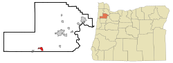
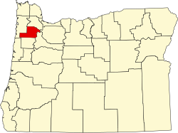
Sheridan is a city in Yamhill County, Oregon, United States. Platted in the 1860s when it received a post office, the city was incorporated in 1880. A major fire burned much of the city in 1913, and a flood covered much of the city in 1964. The population of the city as of the 2020 Census was 6,100, a decrease from 6,127 at the 2010 census. [5]

Contents

Located in the western part of the Willamette Valley, the city is at the base of the Northern Oregon Coast Range along the South Yamhill River. Sheridan lies west of the county seat of McMinnville, along Oregon Route 18. This highway and Oregon Route 18 Business run east–west through Sheridan and nearby Willamina, parallel to the river. Sheridan Bridge is the only river crossing within Sheridan.

This farming and timber community's largest employer is Federal Correctional Institution, Sheridan, a federal minimum and medium security prison. The city has a Mayor–council form of government, with daily operations run by a city manager. The community has its own school district, with a single traditional high school. The main events each year in town are Sheridan Days and the Mud Drags, both held in June. Sheridan was named in honor of the American Civil War general Philip Henry Sheridan.

History

Absolem B. Faulconer laid out the plat for what became the city of Sheridan in the mid-1860s. This plat was recorded with the county on December 13, 1866. [6] He had settled in the area in 1847. [6] The Sheridan post office was established on April 4, 1866, with Absolem's brother Thomas serving as postmaster. [6] By 1871 the town had grown to include two blacksmith shops, one church, one school, one hotel, one wagon shop, and two general stores. [6] In October 1878, the Dayton, Sheridan and Grand Ronde Railroad, a narrow gauge railway, reached the community. [6]

The city, a timber and farming community southwest of Portland and northwest of Salem, was incorporated in 1880. [7] Sheridan was named for General Philip Sheridan, who was posted to Yamhill County and Fort Yamhill in the latter half of the 1850s to monitor the Native Americans at what is now the Grand Ronde Reservation west of the city. [7] By 1894, the city had grown to 400 residents, one bank, two hotels, three churches, and a flouring mill. [8] At that time there was a daily train to the city as well as daily stage coach service from McMinnville, and a single wooden bridge over the river. [8]

Agriculture was the main industry in the city's early years. [9] Around 1910, the main crops included hops, clover-seed, hay, potatoes, onions, and a variety of fruits including apples, prunes, and pears. [9] In March 1910, 150 workers at a lumber yard owned by the Sheridan Lumber Company went on strike for higher wages. The strike was supported by Portland members of the Industrial Workers of the World who picketed employment agencies in Portland to prevent the company from hiring strikebreakers. The action was successful and the workers won a pay increase of twenty-five cents per day, [10] [11] equivalent to $8.18in 2023. [12] On July 18, 1913, a fire that destroyed most of the commercial district caused $300,000 in damage. [6] Most of the buildings were rebuilt with brick within six months. [6] On October 30, 1930, the Jesuits purchased an 891-acre (361 ha) farm on a hill overlooking the city. [13] There they started St. Francis Xavier's Novitiate, a school for training priests for the order. [13] Opening in a new building and several existing farm buildings in 1931, St. Francis Xavier's added more buildings over the next several decades. [13]

In 1932, the state built a highway through Sheridan from McMinnville to the Oregon Coast, which became Oregon Route 18 or the Salmon River Highway. With funds received through the Works Progress Administration, the current steel bridge across the South Yamhill River was built and opened in 1939. [14] By 1940, agriculture was still a major industry, and the timber industry was growing in importance to the local economy. [15] At that time the city had grown to a population of 1,008 people. [15]

Sheridan's City Hall, a former savings and loan, built to resemble the old train depot Sheridan, Oregon City Hall.JPG
Sheridan's City Hall, a former savings and loan, built to resemble the old train depot

The state built a bypass around Sheridan and Willamina that opened in 1957 to carry Oregon Route 18 on the south end of the city. The old alignment through the center of town became Oregon Route 18 Business. Sheridan had its largest flooding in history on December 22, 1964. [16] The South Yamhill overflowed its banks and isolated the town for two days. [16] The Jesuits sold their training school in 1974 to the Delphian Foundation, [17] who then opened The Delphian School at the site in 1976. [18]

In 1989, a federal minimum and medium security prison called the Federal Correctional Institution opened on the south side of the city. [7] At that time, Sheridan had a population of around 2,500 people. [7] Sheridan moved it's city hall into the old railroad station in January 1993, [19] and expanded the renovated building in 1995. [20] The U.S. Census Bureau erroneously listed the city's population as 3,570 in the 2000 Census after mis-listing the prison's population in the wrong census tract. [21] This error of about 2000 people was enough to throw off the state legislative districts beyond their margin of acceptance and the Oregon Supreme Court ruled the Secretary of State must re-draw the boundary lines to match the correct data. [21] [22] The city also counts the prison population as part of the city's official population. In December 2008, a two-alarm fire gutted the 1875 United Methodist Church in the city. [23]

Geography

According to the United States Census Bureau, the city has a total area of 2.01 square miles (5.21 km2), of which, 1.96 square miles (5.08 km2) is land and 0.05 square miles (0.13 km2) is water. [24]

The South Yamhill River divides the city between north and south, and is prone to flooding the city. [8] [16] Deer Creek is the only other stream in the city. Sheridan is located in the western part of the Willamette Valley at an elevation of 189 feet (58 m) above sea level. [25] The city lies at the foothills of the Northern Oregon Coast Range. [7]

Surrounding cities include Willamina about 2 miles (3.2 km) to the west along Oregon 18B, Amity about 9 miles (14 km) due east, and McMinnville about 12 miles (19 km) to the northeast. Other communities include Ballston to the southeast, Shipley due west, Red Prairie to the south, the Gopher Valley to the north and east, and Bellevue to the northeast along Oregon 18. Sheridan is about one-and-a-half miles north of the Polk County line, [8] with the county seat of Dallas approximately 11 miles (18 km) south of Sheridan.

Climate

Sheridan, as part of the Willamette Valley, is within the Marine west coast climate zone. Summers in there are generally warm, but temperatures year-round are moderated by a marine influence from the Pacific Ocean. [26] The city receives most of its precipitation during the mild to cool winter months, with the wettest period from November through March. [26] Sheridan's average annual precipitation totals 47.16 inches (1,198 mm), with the wettest month coming in December. [25] August is the warmest month with an average high temperature of 83 °F (28 °C), while December is the coolest month with an average high of 45 °F (7 °C). [27] December is also on average the wettest month with 8.78 inches (223 mm). [27] July is the driest month of the year, on average. [25] The highest recorded temperature in Sheridan, 106 °F (41 °C), has occurred twice, on July 19, 1956, and August 8, 1981. [28] [29] Sheridan's lowest ever recorded temperature was −11 °F (−24 °C) on January 31, 1950. [30]

Climate data for Sheridan, Oregon
MonthJanFebMarAprMayJunJulAugSepOctNovDecYear
Record high °F (°C)65
(18)
71
(22)
90
(32)
88
(31)
98
(37)
102
(39)
106
(41)
106
(41)
104
(40)
91
(33)
76
(24)
66
(19)
106
(41)
Mean daily maximum °F (°C)45
(7)
50
(10)
55
(13)
60
(16)
67
(19)
73
(23)
81
(27)
81
(27)
77
(25)
65
(18)
51
(11)
44
(7)
62
(17)
Mean daily minimum °F (°C)33
(1)
35
(2)
37
(3)
39
(4)
44
(7)
48
(9)
50
(10)
50
(10)
47
(8)
41
(5)
37
(3)
33
(1)
41
(5)
Record low °F (°C)−11
(−24)
−2
(−19)
10
(−12)
0
(−18)
10
(−12)
10
(−12)
35
(2)
34
(1)
30
(−1)
22
(−6)
9
(−13)
−2
(−19)
−11
(−24)
Average precipitation inches (mm)7.65
(194)
5.86
(149)
4.87
(124)
3.17
(81)
2.14
(54)
1.52
(39)
0.42
(11)
0.54
(14)
1.16
(29)
3.08
(78)
7.70
(196)
9.05
(230)
47.16
(1,198)
Source: The Weather Channel [27]

Transportation

Sheridan Bridge over the South Yamhill River Sheridan Oregon Bridge 1.JPG
Sheridan Bridge over the South Yamhill River

The city is served by two main roads, Oregon Route 18 and Oregon Route 18 Business. [25] The business route, also known as Main Street, runs through downtown on the north side of the South Yamhill River and connects to Shipley and Willamina, to the west. The Sheridan Bridge on Bridge Street connects the two sides of the city across the river. The railroad has the only other bridge crossing the river in the city. Oregon Route 18 connects to McMinnville, the county seat, and beyond to the Portland metropolitan area to the east. Other major roads include Sheridan Street, Mill Street, Sherman Street, Cherry Hill Road, and Rock Creek Road.

Willamette & Pacific Railroad provides freight rail service to the city, but there is no passenger rail in the city. [25] Sheridan does not have any public use airports, with McMinnville Municipal Airport as the closest public airport. [25] One local private airport is Abba's Airport, but half the airstrip is now part of a solar farm while the other half appears inactive and overgrown. There is public transportation via Yamhill Community Action Partnership with a bus to McMinnville. [31]

Economy

The commercial district on Bridge Street Sheridan Oregon downtown at Bridge and Sheridan roads.JPG
The commercial district on Bridge Street

The economy of Sheridan includes agriculture, timber, manufacturing, and service sector employment. As of 2000, the Spirit Mountain Casino outside of the city employed the most people in the area with 1,000 employees. [25] The federal prison was the largest employer in the city with 500 employees, followed by Liberty Homes with 100 employees at the manufactured homes builder. [25] The closest hospital is the Willamette Valley Medical Center in McMinnville. [25]

The commercial district is centered on Bridge and Main streets, with their intersection as the location of the only traffic signal in the city. [32] [33] There were 12 manufacturing companies in Sheridan, one commercial bank, and one savings and loan as of 2006. [25] Sheridan also has one gas station, two grocery stores, one pharmacy, five restaurants, and two hardware stores among other businesses. [33]

The Delphian School in unincorporated Yamhill County, near Sheridan, houses the offices of Delphi Schools and Heron Books. [34] [35]

Government

City police protection is provided under contract by the Yamhill County Sheriff's Office. [36] The office maintains a substation at Sheridan's city hall. [37] Sheridan Fire District provides fire protection to the city and more than 100 square miles (260 km2) of the surrounding area including neighboring Ballston. [38] The district operates three fire stations, one in the city, and had 35 firefighters as of 1998. [25]

Sheridan is a home rule charter city, with a mayor-council government. [39] [40] Cale George is the mayor, who heads the city council that includes six others, with the mayor voting to break ties. [41] Council members and the mayor are elected to four-year terms. [42] A city manager runs the daily operations of the city's government. City hall is located in the building that once served as the city's train depot. [33]

Sheridan operates its own water and wastewater treatment systems, both built in 1949. [25] Drinking water comes from the South Yamhill River and from springs on Stony Mountain to the north. [32] Sheridan has two city parks, Sheridan City Park that includes a skatepark, and South Park along Oregon Route 18 that features a fishing pond. [43] Additionally, there is the J. A. Art Hebert Memorial Plaza on Bridge Street near the river. [33]

Demographics

Historical population
CensusPop.Note
1880 196
1890 29952.6%
1900 46655.9%
1910 1,021119.1%
1920 979−4.1%
1930 1,0083.0%
1940 1,29428.4%
1950 1,92248.5%
1960 1,763−8.3%
1970 1,8816.7%
1980 2,24919.6%
1990 3,97976.9%
2000 5,56139.8%
2010 6,12710.2%
2020 6,100−0.4%
U.S. Decennial Census [44] [3]
Sheridan's fire station Sheridan Oregon fire station.JPG
Sheridan's fire station

2010 census

As of the census [45] of 2010, there were 6,127 people, 1,543 households, and 1,085 families residing in the city. The population density was 3,126.0 inhabitants per square mile (1,207.0/km2). There were 1,671 housing units at an average density of 852.6 per square mile (329.2/km2). The racial makeup of the city was 74.9% White, 5.5% African American, 4.8% Native American, 2.1% Asian, 0.7% Pacific Islander, 7.6% from other races, and 4.4% from two or more races. Hispanic or Latino of any race were 16.6% of the population.

There were 1,543 households, of which 41.0% had children under the age of 18 living with them, 48.0% were married couples living together, 15.4% had a female householder with no husband present, 6.9% had a male householder with no wife present, and 29.7% were non-families. 23.0% of all households were made up of individuals, and 8.9% had someone living alone who was 65 years of age or older. The average household size was 2.77 and the average family size was 3.22.

The median age in the city was 35.7 years. 20.5% of residents were under the age of 18; 8.8% were between the ages of 18 and 24; 38% were from 25 to 44; 23.8% were from 45 to 64; and 8.9% were 65 years of age or older. The gender makeup of the city was 63.8% male and 36.2% female.

The average household size was 2.92, while the median income for a household in the city was $49,940. [5]

Education

Primary and secondary schools

Public schools

Sheridan Japanese School Sheridan Japanese School front.JPG
Sheridan Japanese School

Sheridan is served by the Sheridan School District, which includes four schools. The Faulconer-Chapman School serves 608 students in grades kindergarten through eighth. [46] Sheridan High School is the main high school, with students in grades nine through twelve. Known as the Spartans, the Class 3A school has an enrollment of 287. [46] Opportunity House house is an alternative high school with 49 students in grades ten through twelve, while the Sheridan Japanese School (a charter school) had 88 students in grades four through twelve. [46] As of 2008, the district had 1,042 [46] students and 69 staff members. [25] But in June 2022, the school shut down permanently due to finance problems and not enough students applying to the school the year after.

Private schools

The Delphian School, a K-12 Scientology-affiliated private school, is located in unincorporated Yamhill County, near Sheridan. [47] [48] The school uses the study methods known as Study Tech that were developed by Church of Scientology founder L. Ron Hubbard. [49] Enrollment at the kindergarten through twelfth grade school is 260 students, which includes a majority of students living in dorms on the campus. [50]

Colleges and universities

There are no colleges in Sheridan, but the city is within the Chemeketa Community College district that includes a campus in McMinnville. [51] Linfield College, also in McMinnville, is the closest four-year college with Western Oregon University in Monmouth, Willamette University in Salem, and George Fox University in Newberg all located in the surrounding areas. [52]

Culture

Travelers Home on the National Register of Historic Places Travelers Home - Sheridan Oregon.jpg
Travelers Home on the National Register of Historic Places

Built in 1892, Travelers Home on northeast Yamhill was added to the National Register of Historic Places (NRHP) in 1982, and is the only building on the NRHP in Sheridan (as of 2011). [53] The city operates a single branch public library at Bridge and Yamhill streets on the north side of the city. [25] The library is a member of the Chemeketa Cooperative Regional Library Service and is housed in a 3,000-square-foot (280 m2), one-story building. [54] In 2007, it had a collection of 33,792 items with a circulation of 187,000 among 4,256 registered users. [54]

The local newspaper is the once per week The Sun , published on Wednesdays. [55] The paper was founded in 1890 and has a circulation of 1,263. [55] Broadcast radio and television stations from Portland are also available, as is the regional newspaper The Oregonian , also from Portland. [25]

The city hosts two main annual events, Sheridan Hometown Days and the Mud Drags. Hometown Days takes place over a weekend each June and includes a parade. [56] Most events are held at the high school and includes carnival type activities and rides. [57] The Mud Drags are held in early June and sponsored by the local Rotary International group. [58] Competitors race vehicles through the mud to win prize money. [59] The event draws crowds of 4,000 and includes a children's race through the mud. [59]

Civic groups include those involved in history, fraternal groups, and commercial promotion. The Sheridan Museum of History is a building-less group with a collection of artifacts and photographs displayed in borrowed space, including at the Yamhill County Historical Society Museum in McMinnville. [60] Commercial groups include the Sheridan Chamber of Commerce and the West Valley Chamber of Commerce. [61] Other civic groups include the Rotary International club, the Kiwanis, a Rebekah Lodge, and the Woman's Study Club of Sheridan.

McMinnville UFO Photographs

In May 1950, the Sheridan farm of Paul and Evelyn Trent was the scene of the famous UFO sighting which produced the controversial McMinnville UFO photographs, first published in the McMinnville Telephone-Register and later in Life Magazine. Although these pictures have come to be known as "The McMinville UFO Photographs", the Trent farm was actually located in Sheridan, not McMinnville, which is approximately nine miles to the northeast of Sheridan.

Notable people

The city is home to several notable people. Barbara Roberts, who served in the state legislature and as Oregon Secretary of State before election as Governor of Oregon grew up in Sheridan and graduated from Sheridan High School. [62] High jumper Joni Huntley also graduated from the high school and won a bronze medal at the 1984 Summer Olympics in Los Angeles, California. [63] Wally Heider, recording engineer and recording studio owner, who recorded musicians from the Big Band era to the Grateful Dead and whose work advanced the state of the art of musical recording, grew up in Sheridan, before attending the University of Oregon.

See also

Related Research Articles

<span class="mw-page-title-main">Salem, Oregon</span> Capital city of Oregon, United States

Salem is the capital city of the U.S. state of Oregon, and the county seat of Marion County. It is located in the center of the Willamette Valley alongside the Willamette River, which runs north through the city. The river forms the boundary between Marion and Polk counties, and the city neighborhood of West Salem is in Polk County. Salem was founded in 1842, became the capital of the Oregon Territory in 1851, and was incorporated in 1857.

<span class="mw-page-title-main">Yamhill County, Oregon</span> County in Oregon, United States

Yamhill County is one of the 36 counties in the U.S. state of Oregon. As of the 2020 census, the population was 107,722. The county seat is McMinnville. Yamhill County was named after the Yamhelas, members of the Kalapuya Tribe.

<span class="mw-page-title-main">Polk County, Oregon</span> County in Oregon, United States

Polk County is one of the 36 counties in the U.S. state of Oregon. As of the 2020 census, the population was 87,433. The county seat is Dallas. The county is named for James Knox Polk, the 11th president of the United States.

<span class="mw-page-title-main">Dayton, Oregon</span> City in Oregon, United States

Dayton is a city in Yamhill County, Oregon, United States. The population was 2,678 at the 2020 census.

<span class="mw-page-title-main">McMinnville, Oregon</span> City in Oregon, United States

McMinnville is the county seat of and most populous city in Yamhill County, Oregon, United States. The city is named after McMinnville, Tennessee. As of the 2020 census, the city had a population of 34,319.

<span class="mw-page-title-main">Willamina, Oregon</span> City in Oregon, United States

Willamina is a city in Polk and Yamhill Counties in the U.S. state of Oregon. The population was 2,239 at the 2020 census.

<span class="mw-page-title-main">Yamhill River</span> River in Oregon, United States

The Yamhill River is an 11-mile (18 km) tributary of the Willamette River, in the U.S. state of Oregon. Formed by the confluence of the South Yamhill River and the North Yamhill River about 3 miles (5 km) east of McMinnville, it drains part of the Northern Oregon Coast Range. The river meanders east past Dayton to join the Willamette River at its river mile (RM) 55 or river kilometer (RK) 89, south of Newberg.

<span class="mw-page-title-main">South Yamhill River</span> River in Oregon, United States

The South Yamhill River is a tributary of the Yamhill River, approximately 60 miles (97 km) long, in northwest Oregon in the United States. It drains an area of the Northern Oregon Coast Range, as well as part of the Willamette Valley west of the Willamette River.

<span class="mw-page-title-main">Oregon Route 18</span> Highway in Oregon, United States

Oregon Route 18 is a state highway that runs between the Oregon Coast, near Lincoln City, and Newberg. OR 18 traverses the Salmon River Highway No. 39 of the Oregon state highway system, named after the river alongside its westernmost segments.

<span class="mw-page-title-main">Chemeketa Community College</span> Community college in Salem, Oregon, U.S.

Chemeketa Community College is a public community college in Salem, Oregon, with a campus in McMinnville, and education centers in Dallas, Brooks, and Woodburn. In addition, the college has a Center for Business and Industry in downtown Salem that houses the Small Business Development Center. It operates classes and programs benefiting area businesses.

<span class="mw-page-title-main">Willamette Valley AVA</span> Wine region in Oregon, United States

The Willamette Valley AVA is an American Viticultural Area which lies in the Willamette Valley of Oregon. The AVA is the wine growing region which encompasses the drainage basin of the Willamette River. It stretches from the Columbia River in the north to just south of Eugene in the south, where the Willamette Valley ends; and from the Oregon Coast Range in the west to the Cascade Mountains in the east. At 5,360 square miles (13,900 km2), it is the largest AVA in the state, and contains most of the state's wineries; approximately 908 as of 2021.

<i>Altona</i> (sternwheeler)

The steamship Altona operated from 1890 to 1907 on the Willamette River in the U.S. state of Oregon. In 1907, she was transferred to Alaska.

<span class="mw-page-title-main">Erratic Rock State Natural Site</span>

Erratic Rock State Natural Site is a state park in the Willamette Valley of Oregon, United States. Featuring a 40-short-ton (36 t) glacial erratic from the Missoula Floods, the small park sits atop a foothill of the Northern Oregon Coast Range in Yamhill County between Sheridan and McMinnville off Oregon Route 18. The day use only park is owned and maintained by the Oregon Parks and Recreation Department.

<span class="mw-page-title-main">Willamette Valley Medical Center</span> Hospital in Oregon, United States

Willamette Valley Medical Center is a for-profit Level III acute care hospital in McMinnville, Oregon, United States, adjacent to the McMinnville Airport on Oregon Route 18. Opened at a different location as McMinnville Community Hospital, the four-story medical center has 60 licensed hospital beds. It is owned by Lifepoint.

<span class="mw-page-title-main">Dayton, Sheridan and Grande Ronde Railroad</span> Defunct railroad in Oregon, United States

The Dayton, Sheridan and Grand Ronde Railroad (DS&GR) was a 3 ft narrow gauge railroad in Yamhill and Polk counties in the U.S. state of Oregon.

The Sheridan School District 48J is a unified school district that serves the Sheridan area in the U.S. state of Oregon. The district has four schools and 1,042 students. District offices are in Sheridan on Bridge Street at the high school. Dorie Vickery is the district superintendent, with oversight by the five-member school board. The district is part of the Willamette Education Service District.

<span class="mw-page-title-main">Southern Pacific Red Electric Lines</span> Former interurban railway system in Oregon

The Southern Pacific Red Electric Lines, also known simply as the Red Electric, was a network of interurban passenger train services operated by the Southern Pacific Railroad in the Willamette Valley of the U.S. state of Oregon from 1914 to 1929. The service got its name from the bright red color of its cars. Despite its short history, among West Coast interurbans it was unique, and it was considered the finest such system in the Pacific Northwest. It was the only major electric interurban railroad converted from steam to electric passenger use. It was also one of few systems using all-steel equipment, and one of the largest 1500-volt systems in the country.

<span class="mw-page-title-main">Yamhill River lock and dam</span> Dam in Lafayette, Oregon

The Yamhill River lock and dam was completed in 1900. It was built near Lafayette, Oregon, to allow better river transport on the Yamhill River from Dayton, to McMinnville, Oregon. While the Corps of Engineers had recommended against construction of the lock, it was built anyway, largely as a result of political effort by the backers of the project. For almost forty years prior to the lock construction there had been efforts made to construct a lock and dam on the Yamhill River.

<i>Bonita</i> (1900 sternwheeler)

Bonita was a steamboat which operated on the Willamette and Yamhill rivers. This boat was renamed Metlako in 1902, and operated under that name until 1924 on the Columbia River and its tributaries, the Cowlitz, Lewis and Lake rivers. In 1924, Metlako was renamed B. H. Smith Jr., operating under that name until 1931, when the steamer was abandoned. As Bonita, in September 1900, this vessel was the first steamer to pass through the Yamhill locks.

<span class="mw-page-title-main">Chemeketa Cooperative Regional Library Service</span> Regional coordinating body for public library services to the middle Willamette Valley, Oregon, USA

The Chemeketa Cooperative Regional Library Service (CCRLS) is a library cooperative serving residents of the Chemeketa Community College district, which includes most of Polk, Yamhill, and Marion Counties, and a small portion of Linn County in Oregon. The CCRLS offices are located on the campus of the Chemeketa Community College in Hayesville, an unincorporated suburb northeast of Salem, Oregon. The Cooperative works in tandem with member libraries to determine services, policies, and procedures. The organization is governed by the College Board of Education, with input from the CCRLS Advisory Council, which is made up of one "lay member" from each county and representing the rural areas, five library directors, and one city manager. Although considered a public library by the State of Oregon, CCRLS has no holdings of its own, instead operating as a service overlay to coordinate 16 independent and locally owned libraries into a cohesive system able to provide service to all citizens of the district.

References

  1. "ArcGIS REST Services Directory". United States Census Bureau. Retrieved October 12, 2022.
  2. 1 2 U.S. Geological Survey Geographic Names Information System: Sheridan, Oregon
  3. 1 2 "Census Population API". United States Census Bureau. Retrieved October 12, 2022.
  4. "U.S. Census website". United States Census Bureau . Retrieved January 31, 2008.
  5. 1 2 "Sheridan (city)". State & County QuickFacts. U.S. Census Bureau. Archived from the original on August 9, 2014. Retrieved March 23, 2012.
  6. 1 2 3 4 5 6 7 Stoller, Ruth. "Sheridan - A. B. Faulconer's Town" (PDF). Retrieved August 22, 2009.
  7. 1 2 3 4 5 Mortenson, Eric (May 20, 1989). "Sheridan becomes a prison town". Register-Guard. pp. 1A and 4A.
  8. 1 2 3 4 Edward Gardner Jones, ed. (1894). The Oregonian's handbook of the Pacific Northwest. Oregonian Publishing Company. p.  258. sheridan oregon.
  9. 1 2 Mosessohn, M. (July 1910). "In the Valley of Content". Sunset. XXV: 112–113.
  10. Upton, Austin. "IWW Yearbook 1910". IWW History Project. University of Washington . Retrieved April 19, 2016.
  11. Nef, Walter T. (March 26, 1910). "Accounts of the Strike at Sheridan, Oregon". Industrial Worker . Vol. 2, no. 1. p. 1.
  12. 1634–1699: McCusker, J. J. (1997). How Much Is That in Real Money? A Historical Price Index for Use as a Deflator of Money Values in the Economy of the United States: Addenda et Corrigenda (PDF). American Antiquarian Society. 1700–1799: McCusker, J. J. (1992). How Much Is That in Real Money? A Historical Price Index for Use as a Deflator of Money Values in the Economy of the United States (PDF). American Antiquarian Society. 1800–present: Federal Reserve Bank of Minneapolis. "Consumer Price Index (estimate) 1800–" . Retrieved February 29, 2024.
  13. 1 2 3 Schoenberg, Wilfred P. (June 1959). Jesuits in Oregon. The Oregon-Jesuit.
  14. Pointer, Starla (June 24, 2006). "'It's the thrill of the search' – Marge Owens". News-Register .
  15. 1 2 Writers' Program of the Work Projects Administration in the State of Oregon (1940). Oregon: End of the Trail. American Guide Series. Portland, Oregon: Binfords & Mort. pp.  492–493. OCLC   4874569.
  16. 1 2 3 Daquilante, Paul (January 26, 2008). "Sheridan gets advice on next big one". News-Register. Archived from the original on July 14, 2011. Retrieved August 24, 2009.
  17. Staff and news service reports (June 25, 1999). "The Sheridan novitiate". Catholic Sentinel. Retrieved August 26, 2009.
  18. Associated Press (January 3, 1978). "Delphian School sets sights high". Register-Guard. p. 3B. Retrieved August 26, 2009.
  19. "Sheridan City Hall moves into the renovated train station depot". News-Register. January 23, 1993. p. 1.
  20. "Sheridan City Hall being remodeled and enlarged to make more room for the YCSO West Valley substation". News-Register. November 30, 1995. p. 12.
  21. 1 2 Hartung v. Bradbury, 332 Or. 570, 33 P.3d 972 (2001)
  22. Bradbury gives court new map on redistricting. The Oregonian , November 29, 2001.
  23. Daquilante, Paul (December 25, 2008). "Sheridan loses 1875 church building". News-Register. Archived from the original on July 14, 2011. Retrieved August 22, 2009.
  24. "US Gazetteer files 2010". United States Census Bureau. Archived from the original on January 25, 2012. Retrieved December 21, 2012.
  25. 1 2 3 4 5 6 7 8 9 10 11 12 13 14 15 "Sheridan Community Profile". Oregon Business. Archived from the original on December 28, 2009. Retrieved August 22, 2009.
  26. 1 2 Taylor, George (July 2005). "Climate of Oregon". Oregon Climate Service. Archived from the original on October 15, 2007.
  27. 1 2 3 "Monthly Averages for Sheridan, Oregon". The Weather Channel. Retrieved April 3, 2013.
  28. "August Daily Averages for Sheridan, Oregon". The Weather Channel Interactive, Inc. Retrieved August 25, 2009.
  29. "July Daily Averages for Sheridan, Oregon". The Weather Channel Interactive, Inc. Retrieved August 25, 2009.
  30. "January Daily Averages for Sheridan, Oregon". The Weather Channel Interactive, Inc. Retrieved August 25, 2009.
  31. "Frequently Asked Questions". City of Sheridan. Retrieved August 22, 2009.
  32. 1 2 Daquilante, Paul (February 24, 2007). "No rush to judgment in building collapse". News-Register. Archived from the original on July 14, 2011. Retrieved August 24, 2009.
  33. 1 2 3 4 Klooster, Karl (August 30, 2008). "Sheridan's central scene". News-Register. Archived from the original on July 14, 2011. Retrieved August 24, 2009.
  34. "About Delphi Schools, Inc. Archived 2011-07-25 at the Wayback Machine " The Delphian School. Retrieved on December 27, 2010. "Delphian School 20950 SW Rock Creek Road Sheridan, Oregon 97378."
  35. "How to Contact Us Archived 2010-12-07 at the Wayback Machine ." Heron Books. Retrieved on December 27, 2010. "Postal Address: Heron Books 20750 SW Rock Creek Road Sheridan, OR 97378 USA
  36. "Organization Chart". Yamhill County Sheriff's Office. June 16, 2008. Archived from the original on March 26, 2009. Retrieved August 22, 2009.
  37. Staff (August 12, 2009). "Traffic stop results in charges". News-Register. Archived from the original on July 14, 2011. Retrieved August 22, 2009.
  38. Daquilante, Paul (February 10, 2009). "Sheridan lands fire grant". News-Register. Archived from the original on July 14, 2011. Retrieved August 22, 2009.
  39. "City Charter". City of Sheridan. Retrieved August 22, 2009.
  40. "III" (PDF), Charter, City of Sheridan[ permanent dead link ]
  41. Staff (May 6, 2008). "Sheridan fills city council vacancy". News-Register. Archived from the original on July 14, 2011. Retrieved August 22, 2009.
  42. "Your Elected Officials". City of Sheridan. Retrieved August 22, 2009.
  43. "Parks". City of Sheridan. Retrieved August 24, 2009.
  44. "Census of Population and Housing". Census.gov. Retrieved June 4, 2015.
  45. "U.S. Census website". United States Census Bureau . Retrieved December 21, 2012.
  46. 1 2 3 4 "Oregon School Directory 2008-09" (PDF). Oregon Department of Education. p. 88. Archived from the original (PDF) on May 26, 2011. Retrieved June 11, 2009.
  47. "Sheridan city, Oregon [ permanent dead link ]." U.S. Census Bureau. Retrieved on December 27, 2010.
  48. "Contact Us Archived 2011-04-17 at the Wayback Machine ." The Delphian School. Retrieved on December 27, 2010. "Delphian School 20950 SW Rock Creek Road Sheridan, Oregon 97378"
  49. "Empower Them as Students". delphian.org. The Delphian School. Archived from the original on July 16, 2011. Retrieved December 16, 2010.
  50. "Delphian School". high-schools.com. High-Schools.com. Retrieved December 16, 2010.
  51. "McMinnville Campus". chemeketa.edu. Chemeketa Community College. Archived from the original on December 10, 2010. Retrieved December 16, 2010.
  52. "Schools". City of Sheridan. Retrieved August 26, 2009.
  53. "Oregon National Register List" (PDF). Oregon Parks and Recreation Department. June 6, 2011. p. 50. Retrieved September 28, 2013.
  54. 1 2 "2006-2007". Oregon Public Library Statistics. Oregon State Library . Retrieved August 24, 2009.[ permanent dead link ]
  55. 1 2 "The Sun". Members. Oregon Newspaper Publishers Association. Archived from the original on July 10, 2003. Retrieved August 24, 2009.
  56. Daquilante, Paul (June 20, 2019). "Sheridan Hometown Days gets a thumbs up". News-Register. Retrieved October 8, 2020.
  57. Daquilante, Paul (June 24, 2009). "Sheridan Days rock but most miss out". News-Register. Archived from the original on July 14, 2011. Retrieved August 22, 2009.
  58. Shockley, Troy (June 10, 2009). "Mud drags a family tradition for this clan". News-Register. Archived from the original on July 14, 2011. Retrieved August 22, 2009.
  59. 1 2 Morrill, Tyler. "Mud drags return to Sheridan". News-Register.
  60. "Historical Groups". History. City of Sheridan. Retrieved August 26, 2009.
  61. "Service Clubs". Community. City of Sheridan. Retrieved August 26, 2009.
  62. Mapes, Jeff (October 7, 1990). "Barabara Roberts; Campaign '90 The Race for Governor". The Oregonian. p. A1.
  63. Goe, Ken (June 22, 2008). "Olympics: Olympic track and field medalists from Oregon". The Oregonian.