Yamhill County is one of the 36 counties in the U.S. state of Oregon. As of the 2020 census, the population was 107,722. The county seat is McMinnville. Yamhill County was named after the Yamhelas, members of the Kalapuya Tribe.

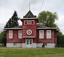
Carlton is a city in Yamhill County, Oregon, United States. The population was 2,135 as of the 2020 Census.

Dayton is a city in Yamhill County, Oregon, United States. The population was 2,678 at the 2020 census.

Lafayette is a city in Yamhill County, Oregon, United States on the Yamhill River and Oregon Route 99W. It was founded in 1846 and incorporated in 1878. The population was 4,423 at the 2020 census.
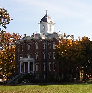
McMinnville is the county seat of and largest city in Yamhill County, Oregon, United States. The city is named after McMinnville, Tennessee. As of the 2020 census, the city had a population of 34,319.

Sheridan is a city in Yamhill County, Oregon, United States. Platted in the 1860s when it received a post office, the city was incorporated in 1880. A major fire burned much of the city in 1913, and a flood covered much of the city in 1964. The population of the city as of the 2020 Census was 6,100, a decrease from 6,127 at the 2010 census.

Willamina is a city in Polk and Yamhill Counties in the U.S. state of Oregon. The population was 2,239 at the 2020 census.

The Yamhill River is an 11-mile (18 km) tributary of the Willamette River, in the U.S. state of Oregon. Formed by the confluence of the South Yamhill River and the North Yamhill River about 3 miles (5 km) east of McMinnville, it drains part of the Northern Oregon Coast Range. The river meanders east past Dayton to join the Willamette River at its river mile (RM) 55 or river kilometer (RK) 89, south of Newberg.

The North Yamhill River is a 31-mile (50 km) tributary of the Yamhill River in the U.S. state of Oregon. It drains an area of the Northern Oregon Coast Range, as well as part of the Willamette Valley west of the Willamette River.

The South Yamhill River is a tributary of the Yamhill River, approximately 60 miles (97 km) long, in northwest Oregon in the United States. It drains an area of the Northern Oregon Coast Range, as well as part of the Willamette Valley west of the Willamette River.
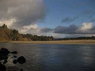
The Salmon River flows from the Central Oregon Coast Range to the Pacific Ocean coast of northwest Oregon in the United States. About 24 miles (39 km) long, it begins and ends in Lincoln County but also flows briefly through western Polk and southern Tillamook counties. Much of its course lies within the Siuslaw National Forest.

Oregon Route 18 is a state highway that runs between the Oregon Coast, near Lincoln City, and Newberg. OR 18 traverses the Salmon River Highway No. 39 of the Oregon state highway system, named after the river alongside its westernmost segments.
Perrydale is an unincorporated community in Polk County, Oregon, United States. It is approximately 10 miles from Dallas. It is part of the Salem Metropolitan Statistical Area.

Whiteson is an unincorporated community in Yamhill County, Oregon, United States. Oregon Geographic Names states that Whiteson is named for either for Henry White, who laid out the town site and gave the railroad right-of-way, or for William White. It is possible they are members of the same family. Whiteson post office was established in 1890. Whiteson is an agricultural community lacking either Oregon hamlet or village classification, and relies on the neighboring communities of McMinnville and Amity for basic services such as fire, health, and education. The Yamhill County Sheriff has primary police jurisdiction over Whiteson.

Springbrook is an unincorporated community within the city of Newberg, in Yamhill County, Oregon, United States. The community was originally named "Hoskins", after pioneer Cyrus E. Hoskins, who settled in the area. When a post office was established on June 30, 1893, the name was changed to Springbrook, since there was already a Hoskins, Oregon in Benton County. The post office closed in 1961.
Gopher Valley is a valley in Yamhill County, Oregon, United States. Gopher, Oregon was an unincorporated locale in the valley. Gopher post office ran from April 6, 1899 to September 14, 1905, with Edward H. Taylor first postmaster.

Hopewell is an unincorporated community in Yamhill County, Oregon, United States. It is at the eastern terminus of Oregon Route 153, 10 miles (16 km) south of Dayton and a few miles west of Wheatland, at the east base of the Eola Hills.

Mountaindale is an unincorporated community in Washington County, Oregon, United States, about four miles northwest of North Plains. Settled in the 1850s, the small community was the longtime home of the Mountaindale Store. The area is part of Washington County Fire District 2.
Saint Joseph is an unincorporated community in Yamhill County, Oregon, United States. It is located about two miles west of Lafayette near Oregon Route 99W. The area is sometimes known as "St. Joe".
Pleasant Valley is an unincorporated community in Baker County, Oregon, United States. It is about 13 miles (21 km) southeast of Baker City on U.S. Route 30, slightly bypassed by Interstate 84.