Riverside, Yamhill County, Oregon

Last updated
Riverside
Houses in Riverside, Yamhill County, Oregon.JPG
Houses in the community
USA Oregon location map.svg
Red pog.svg
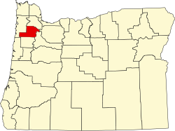
Riverside
Location within the state of Oregon
Usa edcp location map.svg
Red pog.svg
Riverside
Riverside (the United States)
Coordinates: 45°05′19″N123°27′09″W / 45.08861°N 123.45250°W / 45.08861; -123.45250 Coordinates: 45°05′19″N123°27′09″W / 45.08861°N 123.45250°W / 45.08861; -123.45250
Country United States
State Oregon
County Yamhill
Elevation
213 ft (65 m)
Time zone UTC-8 (Pacific (PST))
  Summer (DST) UTC-7 (PDT)
GNIS feature ID1163488 [1]

Riverside is an unincorporated historic locale in Yamhill County, Oregon, United States. It lies at an elevation of 213 feet (65 m). [1]

Related Research Articles

Yamhill County, Oregon County in Oregon, United States

Yamhill County is one of the 36 counties in the U.S. state of Oregon. As of the 2020 census, the population was 107,722. The county seat is McMinnville. Yamhill County was named after the Yamhelas, members of the Kalapuya Tribe.

Riverside, Oregon may refer to one of these places in the U.S. state of Oregon:

Carlton, Oregon City in Oregon, United States

Carlton is a city in Yamhill County, Oregon, United States. The population was 2,135 as of the 2020 Census.

McMinnville, Oregon City in Oregon, United States

McMinnville is the county seat of and largest city in Yamhill County, Oregon, United States. The city is named after McMinnville, Tennessee. As of the 2019 census, the city had a population estimate of 34,743.

Yamhill, Oregon City in Oregon, United States

Yamhill is a city in Yamhill County, Oregon, United States. Located in the northern part of the county, it is situated at the intersection of Oregon Route 47 and Oregon Route 240. The population was 1,024 at the 2010 census. Originally named North Yamhill, it was incorporated under that name by the Oregon Legislative Assembly on February 20, 1891.

Yamhill River River in Oregon, United States

The Yamhill River is an 11-mile (18 km) tributary of the Willamette River, in the U.S. state of Oregon. Formed by the confluence of the South Yamhill River and the North Yamhill River about 3 miles (5 km) east of McMinnville, it drains part of the Northern Oregon Coast Range. The river meanders east past Dayton to join the Willamette River at its river mile (RM) 55 or river kilometer (RK) 89, south of Newberg.

North Yamhill River River in Oregon, United States

The North Yamhill River is a 31-mile (50 km) tributary of the Yamhill River in the U.S. state of Oregon. It drains an area of the Northern Oregon Coast Range, as well as part of the Willamette Valley west of the Willamette River.

South Yamhill River River in Oregon, United States

The South Yamhill River is a tributary of the Yamhill River, approximately 60 miles (97 km) long, in northwest Oregon in the United States. It drains an area of the Northern Oregon Coast Range, as well as part of the Willamette Valley west of the Willamette River.

Whiteson, Oregon Unincorporated community in the State of Oregon, United States

Whiteson is an unincorporated community in Yamhill County, Oregon, United States. Oregon Geographic Names states that Whiteson is named for either for Henry White, who laid out the town site and gave the railroad right-of-way, or for William White. It is possible they are members of the same family. Whiteson post office was established in 1890. Whiteson is an agricultural community lacking either Oregon hamlet or village classification, and relies on the neighboring communities of McMinnville and Amity for basic services such as fire, health, and education. The Yamhill County Sheriff has primary police jurisdiction over Whiteson.

Fort Yamhill

Fort Yamhill was an American military fortification in the state of Oregon. Built in 1856 in the Oregon Territory, it remained an active post until 1866. The Army outpost was used to provide a presence next to the Grand Ronde Agency Coastal Reservation. Several officers stationed at the United States Army post prior to the American Civil War would later serve as generals in that war.

Shipley, Oregon Unincorporated community in the State of Oregon, United States

Shipley, Oregon is an unincorporated community in Yamhill County, Oregon, United States. Most of the area has been annexed by the city of Sheridan.

Bald Peak State Scenic Viewpoint State park in Oregon, USA

Bald Peak State Scenic Viewpoint is a state park located atop Bald Peak located in Yamhill County, in the United States. The day use only park offers picnic tables and a hiking trail for views of the Willamette Valley and the Cascade Range. The state of Oregon acquired the 26 acres (11 ha) in 1931 after Yamhill and Washington counties requested a park from the state.

George K. Gay

George Kirby Gay was an English sailor and later settler in the Oregon Country. He was a member of the Willamette Cattle Company that brought livestock to Oregon and built the first brick house in the United States west of the Rocky Mountains. Gay also participated in the Champoeg Meetings that created a provisional government in what would become the U.S. state of Oregon.

Erratic Rock State Natural Site

Erratic Rock State Natural Site is a state park in the Willamette Valley of Oregon, United States. Featuring a 40-short-ton (36 t) glacial erratic from the Missoula Floods, the small park sits atop a foothill of the Northern Oregon Coast Range in Yamhill County between Sheridan and McMinnville off Oregon Route 18. The day use only park is owned and maintained by the Oregon Parks and Recreation Department.

Palmer Creek (Yamhill River tributary) River in Oregon, United States

Palmer Creek is a tributary of the Yamhill River in northwestern Oregon in the United States. Arising in Polk County it flows north, crossing almost immediately into Yamhill County. It continues generally north, entering the larger stream at Dayton, 5 miles (8 km) upstream of the Yamhill's confluence with the Willamette River.

Fort Hill is an unincorporated community in Polk and Yamhill counties in Oregon, United States. It is located about a mile east of Spirit Mountain Casino on Oregon Route 22 near the South Yamhill River. For statistical purposes, the United States Census Bureau has defined Fort Hill as a census-designated place (CDP). The census definition of the area may not precisely correspond to local understanding of the area with the same name. The hill of the same name, located just east of Valley Junction, was the site of a blockhouse built by settlers in 1855–1856. The blockhouse became part of Fort Yamhill, and was later moved to Grand Ronde Agency and is now located in Dayton.

Yamhill County Transit

Yamhill County Transit, officially the Yamhill County Transit Area (YCTA), is the public transit authority of Yamhill County, Oregon, United States. It operates local bus routes in the cities of McMinnville and Newberg, as well as commuter bus routes to Hillsboro and Tigard in the Portland metropolitan area, Salem, and Grand Ronde.

References

  1. 1 2 "Riverside, Yamhill County, Oregon". Geographic Names Information System . United States Geological Survey.