
The Cascade Range or Cascades is a major mountain range of western North America, extending from southern British Columbia through Washington and Oregon to Northern California. It includes both non-volcanic mountains, such as many of those in the North Cascades, and the notable volcanoes known as the High Cascades. The small part of the range in British Columbia is referred to as the Canadian Cascades or, locally, as the Cascade Mountains. The highest peak in the range is Mount Rainier in Washington at 14,411 feet (4,392 m).

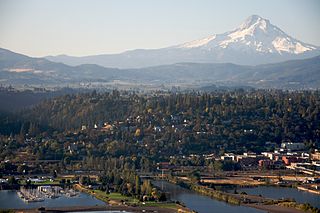
The Willamette River is a major tributary of the Columbia River, accounting for 12 to 15 percent of the Columbia's flow. The Willamette's main stem is 187 miles (301 km) long, lying entirely in northwestern Oregon in the United States. Flowing northward between the Oregon Coast Range and the Cascade Range, the river and its tributaries form the Willamette Valley, a basin that contains two-thirds of Oregon's population, including the state capital, Salem, and the state's largest city, Portland, which surrounds the Willamette's mouth at the Columbia.
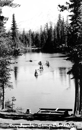
Scouting in the U.S. state of Oregon includes the Boy Scouts of America (BSA) and Girl Scouts (GSUSA) youth organizations, as well as newer organizations like the Baden-Powell Service Association.
Hood River is a city and the seat of Hood River County, Oregon, United States. It is a port on the Columbia River, and is named for the nearby Hood River. As of the 2020 census, the city population was 8,313. It is the only city in Oregon where public consumption of alcohol on sidewalks or parks is totally unrestricted.

The Columbia River Gorge is a canyon of the Columbia River in the Pacific Northwest of the United States. Up to 4,000 feet (1,200 m) deep, the canyon stretches for over eighty miles (130 km) as the river winds westward through the Cascade Range, forming the boundary between the state of Washington to the north and Oregon to the south. Extending roughly from the confluence of the Columbia with the Deschutes River in the east down to the eastern reaches of the Portland metropolitan area, the water gap furnishes the only navigable route through the Cascades and the only water connection between the Columbia Plateau and the Pacific Ocean. It is thus that the routes of Interstate 84, U.S. Route 30, Washington State Route 14, and railroad tracks on both sides run through the gorge.

Multnomah Falls is a waterfall located on Multnomah Creek in the Columbia River Gorge, east of Troutdale, between Corbett and Dodson, Oregon, United States. The waterfall is accessible from the Historic Columbia River Highway and Interstate 84. Spanning two tiers on basalt cliffs, it is the tallest waterfall in the state of Oregon at 620 ft (189 m) in height. The Multnomah Creek Bridge, built in 1914, crosses below the falls, and is listed on the National Register of Historic Places.
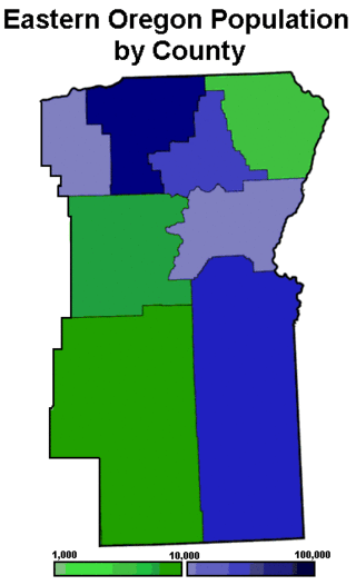
Eastern Oregon is a region of the U.S. state of Oregon. It is not an officially recognized geographic entity; thus, the boundaries of the region vary according to context. It is sometimes understood to include only the eight easternmost counties in the state; in other contexts, it includes the entire area east of the Cascade Range. Cities in the basic eight-county definition include Baker City, Burns, Hermiston, Pendleton, Boardman, John Day, La Grande, and Ontario. Umatilla County is home to the largest population base in Eastern Oregon, accounting for 42% of the region's residents — more than twice that of the region’s second most populous, Malheur County. Hermiston, located in Umatilla County, is the largest city in the region, accounting for 10% of the population. Major industries include transportation/warehousing, timber, agriculture and tourism. The main transportation corridors are I-84, U.S. Route 395, U.S. Route 97, U.S. Route 26, U.S. Route 30, and U.S. Route 20.

The Oregon Coast is a coastal region of the U.S. state of Oregon. It is bordered by the Pacific Ocean to its west and the Oregon Coast Range to the east, and stretches approximately 362 miles (583 km) from the California state border in the south to the Columbia River in the north. The region is not a specific geological, environmental, or political entity, and includes the Columbia River Estuary.

The Rogue River in southwestern Oregon in the United States flows about 215 miles (346 km) in a generally westward direction from the Cascade Range to the Pacific Ocean. Known for its salmon runs, whitewater rafting, and rugged scenery, it was one of the original eight rivers named in the Wild and Scenic Rivers Act of 1968. Beginning near Crater Lake, which occupies the caldera left by the explosive volcanic eruption and collapse of Mount Mazama, the river flows through the geologically young High Cascades and the older Western Cascades, another volcanic province. Further west, the river passes through multiple exotic terranes of the more ancient Klamath Mountains. In the Kalmiopsis Wilderness section of the Rogue basin are some of the world's best examples of rocks that form the Earth's mantle. Near the mouth of the river, the only dinosaur fragments ever discovered in Oregon were found in the Otter Point Formation, along the coast of Curry County.

The Oregon Coast Trail (OCT) is a long-distance hiking route along the Pacific coast of the U.S. state of Oregon in the United States. It follows the coast of Oregon from the mouth of the Columbia River to the California border south of Brookings.

Prospect State Scenic Viewpoint, is a state park south of the community of Prospect on Oregon Route 62 in Jackson County, in the U.S. state of Oregon. It was formerly known as Mill Creek Falls Scenic Area, a private hiking area that was developed by Willamette Industries along the Rogue River. Both Mill Creek Falls and Pearsony Falls are contained within the area, with Barr Creek Falls close by.
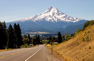
The Mount Hood Highway No. 26 is the Oregon Department of Transportation's designation for a 96.74-mile-long (155.69 km) highway from Portland east around the south side of Mount Hood and north via Bennett Pass to Hood River. It is marked as U.S. Route 26 from Portland to near Mount Hood and Oregon Route 35 the rest of the way to Hood River.

Chanticleer Point is a geographical landmark on the Oregon side of the Columbia River Gorge. It is the first notable overlook encountered traveling east on the Historic Columbia River Highway. It is a typical location from which to take photos of the gorge featuring Crown Point prominently. It overlooks Rooster Rock State Park.

Heceta Head is a headland that stands 1,000 feet (300 m) above the Pacific Ocean in Lane County, Oregon, United States. The Heceta Head Light is located on its south side. Heceta Head is named after a Basque explorer under Spanish commission, Bruno de Heceta, who explored the Pacific Northwest in the 1770s. The headland marks the end of a lower-lying stretch of the coastline to the south dominated by sand dunes; the coastline to the north is more varied. Devils Elbow is the bay south of the headland at the mouth of Cape Creek, and with the headland formed Devils Elbow State Park, which is now part of Heceta Head Lighthouse State Scenic Viewpoint.

Ainsworth State Park is a state park in eastern Multnomah County, Oregon, near Cascade Locks. It is located in the Columbia River Gorge, adjacent to the Historic Columbia River Highway. The park, administered by the Oregon Parks and Recreation Department, offers a seasonal, full-service campground, access to Gorge hiking trails beyond park boundaries, and a day-use area.

Bald Peak State Scenic Viewpoint is a state park located atop Bald Peak located in Yamhill County, in the United States. The day use only park offers picnic tables and a hiking trail for views of the Willamette Valley and the Cascade Range. The state of Oregon acquired the 26 acres (11 ha) in 1931 after Yamhill and Washington counties requested a park from the state.

Interstate 84 (I-84) in the U.S. state of Oregon is a major Interstate Highway that traverses the state from west to east. It is concurrent with U.S. Route 30 (US 30) for most of its length and runs 376 miles (605 km) from an interchange with I-5 in Portland to the Idaho state line near Ontario. The highway roughly follows the Columbia River and historic Oregon Trail in northeastern Oregon, and is designated as part of Columbia River Highway No. 2 and all of the Old Oregon Trail Highway No. 6; the entire length is also designated as the Vietnam Veterans Memorial Highway. I-84 intersects several of the state's main north–south roads, including US 97, US 197, I-82, and US 395.
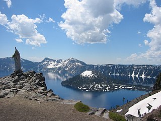
Oregon is 295 miles (475 km) north to south at longest distance, and 395 miles (636 km) east to west. With an area of 98,381 square miles (254,810 km2), Oregon is slightly larger than the United Kingdom. It is the ninth largest state in the United States. Oregon's highest point is the summit of Mount Hood, at 11,249 feet (3,429 m), and its lowest point is the sea level of the Pacific Ocean along the Oregon Coast. Oregon's mean elevation is 3,300 feet (1,006 m). Crater Lake National Park, the state's only national park, is the site of the deepest lake in the United States at 1,943 feet (592 m). Oregon claims the D River as the shortest river in the world, though the state of Montana makes the same claim of its Roe River. Oregon is also home to Mill Ends Park, the smallest park in the world at 452 square inches (0.29 m2).

Cline Falls State Scenic Viewpoint is a state park near Redmond, Oregon, United States. It is located on the Deschutes River. The park covers 9 acres (36,000 m2). It is administered by the Oregon Parks and Recreation Department.

The Eagle Creek Fire was a destructive wildfire in the Columbia River Gorge, largely in the U.S. state of Oregon, with smaller spot-fires in Washington. The fire was started on September 2, 2017, by a 15-year-old boy igniting fireworks during a burn ban. The fire burned 50,000 acres, and burned for three months, before being declared completely contained. As late as May 29, 2018, it was still found smoldering in some areas.
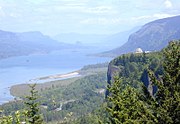 Crown Point and Vista House, taken from Portland Women's Forum viewpoint
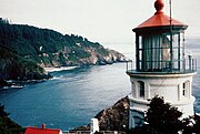 A closeup of the Heceta Head Light tower
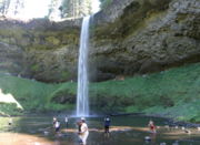 Silver Falls
 Smith Rock
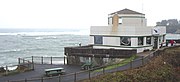 Whale watching center at Depoe Bay
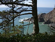 North of Cape Falcon in Oswald West State Park

 Looking north from Cape Sebastian


