There are 52 state parks in the U.S. state of Arkansas, as of 2019. [1] The state parks division of the Arkansas Department of Parks, Heritage, and Tourism is the governing body and operator of all parks, although jurisdiction is shared with other state agencies in a few cases.
The first Arkansas state park, Petit Jean State Park, opened in 1923 following an unsuccessful attempt by a lumber company to donate the Seven Hollows and canyon areas to the federal government as a National Park. [2] Stephen Mather deemed the parcel too small in 1921, but the Arkansas General Assembly passed Act 276, allowing the Commissioner of State Lands to accept donations of land for public use.
The list gives an overview of Arkansas state parks and a brief history of their development since the first park opened in 1923. State parks range in size from 1 acre (0.40 ha) to 11,744 acres (4,753 ha).
Name | County | Size | Estab- lished | River / lake | Image | Remarks |
---|---|---|---|---|---|---|
Arkansas Post Museum | Arkansas | 8 acres (3.2 ha) | 1997 | None | Museum dedicated to the history of Arkansas Post, Arkansas's territorial capital until 1821. Located on the grounds of the Arkansas Post National Memorial (National Park Service) | |
Bull Shoals-White River | Baxter, Marion | 732 acres (296 ha) | 1955 | Bull Shoals Lake | Trout fishing destination above and below Bull Shoals Dam with over 100 campsites | |
Cane Creek | Lincoln | 2,053 acres (831 ha) | 1992 | Cane Creek Lake | Wooded lake along Bayou Bartholomew including a hiking trail and camping | |
Conway Cemetery | Lafayette | 11.5 acres (5 ha) | 1986 | None | Historical state park with no recreational services located on James Sevier Conway's (the first governor of Arkansas) former cotton plantation | |
Cossatot River | Howard, Polk | 5,230 acres (2145 ha) | 1988 | Cossatot River | Class III, IV, and V whitewater rafting river listed on the National Park Service's National Wild and Scenic Rivers System | |
Crater of Diamonds | Pike | 911 acres (369 ha) | 1972 | None | World's only diamond-bearing site accessible to the public | |
Crowley's Ridge | Greene | 291 acres (118 ha) | 1937 | Lake Ponder | Park built on the homestead of Benjamin Crowley, dedicated to the culture and history of the Crowley's Ridge region. Includes many structures built in the 1930s by the Civilian Conservation Corps and spring-fed Lake Ponder | |
Daisy | Pike | 276 acres (112 ha) | 1955 | Lake Greeson | Park nestled within the Ouachita Mountains on Lake Greeson near the Ouachita National Forest. Popular for camping, water sports, and fishing | |
Davidsonville | Randolph | 163 acres (66 ha) | 1957 | Black River | Historic state park preserving the abandoned frontier river town of Davidsonville. Interpretive tours and signs guide visitors through the historic community bypassed by the Southwest Trail in the 1820s. Fishing is available along three nearby rivers, with 49 campsites | |
DeGray Lake | Clark, Hot Spring | 984 acres (398 ha) | 1974 | DeGray Lake | Resort state park with championship rated golf course, 94 room lodge, and over 100 campsites | |
Delta Heritage Trail | Arkansas, Desha, Phillips | 960 acres (390 ha) | 2002 | None | Rails to trails conversion of former railroad bed through Arkansas Delta lowlands, currently 14 miles (23 km), planned to be 73 miles (117 km) | |
Devil's Den | Washington | 2,500 acres (1000 ha) | 1933 | Lee Creek | Civilian Conservation Corps-built park in the Ozarks with lake, caves, swimming pool and several trails. Includes over 100 campsites, including cabins | |
Hampson Archeological Museum | Mississippi | 5 acres (2 ha) | 1961 | None | 
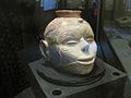
Museum displaying archeological artifacts from the Nodena site, an aboriginal village of the Nodena people dated 1400-1650 CE, and bones from the Island 35 Mastodon | |
Herman Davis | Mississippi | 1 acre (0.4 ha) | 1953 | None | Park surrounding a grave and memorial to Herman Davis, a U.S. sniper during World War I | |
Historic Washington | Hempstead | 101 acres (41 ha) | 1973 | None | Fifty-three buildings that preserve and interpret the architectural, cultural, and political history of a historic nineteenth century town. | |
Hobbs Conservation Area | Benton, Carroll, Madison | 12,056 acres (4879 ha) | 1979 | Beaver Lake | Large park in the Boston Mountains along Beaver Lake featuring trails, camping, and a shooting range. | |
Jacksonport | Jackson | 164.7 acres (66.7 ha) | 1965 | Black River and White River | Park containing the 1872 Jacksonport courthouse, preserving the culture and history of a former steamboat river town | |
Jenkins' Ferry Battleground | Grant | 40 acres (16.2 ha) | 1961 | Saline River | One of three battleground sites from the Camden Expedition of the Civil War. Water recreation available on the Saline River | |
Lake Catherine | Garland, Hot Spring | 2,180 acres (882.2 ha) | 1935 | Lake Catherine | 
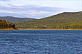
Civilian Conservation Corps park created along the lake, resulting in a well-preserved natural shoreline. Park features cabins, campsites, nature programs, marina, hiking trails, and a sand beach swimming area | |
Lake Charles | Lawrence | 140 acres (57 ha) | 1967 | Lake Charles | 
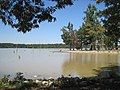
Lake is maintained and stocked with fish by the Arkansas Game and Fish Commission; also features camping, hiking, boat ramps and an interpretative nature center | |
Lake Chicot | Chicot | 211.6 acres (85.6 ha) | 1957 | Lake Chicot | 
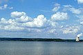
Largest oxbow lake in the United States; formerly the main channel of the Mississippi River. Park is located within a pecan grove within a bayou environment, offering 122 campsites, 14 cabins, swimming pool, boat shop/marina and interpretative visitor center. | |
Lake Dardanelle | Pope | 246 acres (99.6 ha) | 1966 | Lake Dardanelle | Two sites (Russellville and Dardanelle), including 74 campsites, boating, visitor center, and aquarium. Popular for bass fishing, including hosting many major tournaments. | |
Lake Fort Smith | Crawford | 260 acres (105.2 ha) | 1967 | Lake Fort Smith | Large lake in the Ozarks offering 30 campsites, 10 cabins, a marina, swimming pool and visitor center | |
Lake Frierson | Greene | 114 acres (46.1 ha) | 1975 | Lake Frierson | Reservoir built along Crowley's Ridge known for fishing. Features seven campsites, trails, boat ramp and visitor center | |
Lake Ouachita | Garland | 360 acres (145.7 ha) | 1955 | Lake Ouachita | 
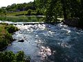
Built surrounding a reservoir, the park features a marina, trails, restaurant, eagle tours, and interpretative information on three historic springs in the park vicinity | |
Lake Poinsett | Poinsett | 132 acres (53.4 ha) | 1963 | Lake Poinsett | Popular with fishing enthusiasts, the park offers 29 campsites, trails and interpretative programs | |
Logoly | Columbia | 368 acres (148.9 ha) | 1974 | None | Environmental education park containing mature oak-hickory forests, mineral springs and endangered species | |
Louisiana Purchase | Lee, Monroe, Phillips | 37.5 acres (15.2 ha) | 1961 | None | Boardwalk through a headwater swamp leading to a monument dedicating the point of beginning of all surveys of the Louisiana Purchase, which allowed for the westward development and expansion of the United States | |
Lower White River Museum | Prairie | 0.4 acres (0.2 ha) | 1975 | White River | Museum dedicated to the preservation and interpretation of culture, commerce and history along the White River in Arkansas | |
Mammoth Spring | Fulton | 623.5 acres (25 ha) | 1957 | Mammoth Spring | Park surrounding the large natural spring, offering fishing, boating and hiking, an Arkansas welcome center and museum | |
Marks' Mills Battleground | Cleveland | 6.2 acres (2.5 ha) | 1961 | None | Park commemorating Civil War battle, including exhibits and park area. Also a Red River Campaign National Historic Landmark. | |
Millwood | Little River | 824 acres (333 ha) | 1976 | Millwood Lake | Forested area surrounding large lake known for bass fishing, bird watching, hiking and camping. | |
Mississippi River | Lee, Phillips | 536 acres (217 ha) | 2009 | Mississippi River | Newest state park created within the St. Francis National Forest. Park currently includes campground at Bear Creek Lake and birding trail. | |
Moro Bay | Bradley | 117 acres (47 ha) | 1972 | Ouachita River | Park at the convergence of Raymond Lake, Moro Bay, and the Ouachita River with visitor center. Popular destination for fishing, water sports, hiking trails and camping. | |
Mount Magazine | Logan | 2,234 acres (904 ha) | 1983 | None | 
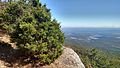
The park contains Mossback Ridge, including the peak of Mount Magazine, Arkansas's highest point. Park also contains The Lodge at Mount Magazine, cabins, trails, and a hang gliding area. | |
Mount Nebo | Yell | 2,984 acres (1208 ha) | 1928 | None | One of three mountain state parks in the Arkansas River Valley, includes historic cabins, 14 miles (23 km) of hiking trails, and popular hang-gliding launch points. | |
Museum of Natural Resources | Union | 19 acres (8 ha) | 1986 | None | Museum preserving and interpreting the history of oil and bromine mining in Arkansas | |
Ozark Folk Center | Stone | 637 acres (258 ha) | 1973 | None | Located near Mountain View, Arkansas, it preserves the music, culture, and traditions of the Ozark Mountains. Hosts special concerts and regular folk music performances. | |
Parkin Mounds | Cross | 107 acres (43 ha) | 1994 | None | ||
Petit Jean | Conway | 3,471 acres (1405 ha) | 1923 | None | Situated atop Petit Jean Mountain in the Arkansas River Valley, offers trails, creeks, and geology throughout the forested mountains | |
Pinnacle Mountain | Pulaski | 2,069 acres (837 ha) | 1973 | None | Rocky Pinnacle Mountain emerges where the flat Arkansas Delta intersects the Ouachita Mountains | |
Plantation Agriculture Museum | Lonoke | 14.5 acres (5.9 ha) | 1985 | None | Former general store serving a community of cotton farmers operating as a museum including over 10,000 artifacts. Grounds also contain farm machinery used on cotton plantations. | |
Plum Bayou Mounds | Lonoke | 185 acres (75 ha) | 1975 | None | ||
Poison Springs Battleground | Ouachita | 85 acres (34 ha) | 1961 | None | Preserves and commemorates the Battle of Poison Spring in the American Civil War, which was part of the 1864 Camden Expedition | |
Powhatan | Lawrence | 9.1 acres (3.7 ha) | 1970 | Black River | Preserves a small nineteenth-century river port town on the Black River | |
Prairie Grove Battlefield | Washington | 840 acres (340 ha) | 1957 | None | Preserves and commemorates the Battle of Prairie Grove in the American Civil War. Park includes a museum, gift shop, and several historic structures from the period relocated to the site around a walking trail. | |
Queen Wilhelmina | Polk | 460 acres (190 ha) | 1957 | None | Lodge atop Rich Mountain offers 38 guest rooms and is surrounded by forested slopes with creeks, trails, and mountain vistas. Located along the Talimena Scenic Drive. | |
South Arkansas Arboretum | Union | 13 acres (5.3 ha) | 1991 | None | Arboretum and botanical garden owned by South Arkansas Community College with plants native to the Western Gulf Coastal Plain region. | |
Village Creek | Cross, St. Francis | 6,909 acres (2,796 ha) | 1972 | Lakes Austell and Dunn | Large park in the eastern part of the state. Rises along Crowley's Ridge from the surrounding Arkansas Delta, includes lakes, twenty-seven-hole golf course, camping, and hiking. One trail follows the 1820s Memphis to Little Rock Road. | |
White Oak Lake | Ouachita, Nevada | 725 acres (293 ha) | 1961 | White Oak Lake | Lake in the woods on the border between Bottomland hardwood forest and loblolly pine forest with diverse wildlife. Camping, boating, fishing, and hiking are popular around the lake. Interpretative signs about the Red River Campaign in the area during the Civil War. | |
Withrow Springs | Madison | 786 acres (318 ha) | 1962 | Withrow Spring | ||
Woolly Hollow | Faulkner | 370 acres (150 ha) | 1973 | None |
Crater of Diamonds State Park is a 911-acre (369 ha) Arkansas state park in Pike County, Arkansas, in the United States. The park features a 37.5-acre plowed field, the world's only diamond-bearing site accessible to the public. Diamonds have continuously been discovered in the field since 1906, including the graded-perfect Strawn-Wagner Diamond, found in 1990, and the Uncle Sam, found in 1924, which at over 40 carats is the largest diamond ever found in the United States.
Mammoth Spring State Park is a 62.5-acre (25.3 ha) Arkansas state park in Fulton County, Arkansas in the United States. The park is located surrounding National Natural Landmark of the same name to provide recreation and interpretation for visitors. The park offers fishing, boating and hiking in addition to an Arkansas Welcome Center and restored 1886 St. Louis–San Francisco Railway (Frisco) depot operating as a railroad museum. The site became a state park in 1957, but the park continued to add area until 1975.
Historic Washington State Park is a 101-acre (41 ha) Arkansas state park in Hempstead County, Arkansas in the United States. The museum village contains a collection of pioneer artifacts from the town of Washington, Arkansas, which is a former pioneer settlement along the Southwest Trail. Walking interpretive tours are available throughout the 54 buildings. Washington served as a major trading point along the Southwest Trail, evolving into the Hempstead county seat and later the capital of Arkansas from 1863 to 1865 when Little Rock was threatened during the Civil War. The original plat of Washington was added to the National Register of Historic Places in 1972 as the Washington Historic District.
Cane Creek State Park is a 2,053-acre (831 ha) Arkansas state park in Lincoln County, Arkansas in the United States. Straddling the Gulf Coastal Plain and the Mississippi Delta, the park includes the 1,675-acre (678 ha) Cane Creek Lake, a wooded lake which borders Bayou Bartholomew, the world's longest bayou. The park became a reality when the U.S. Department of Agriculture’s Soil Conservation Service said it would provide federal funds to the project in 1973, prompting the Arkansas Game and Fish Commission (AGFC) to pledge to build and maintain the lake within the park. The park is characterized by rolling wooded hills, deep draws, and steeply sloping ridges.
Cossatot River State Park-Natural Area is a 5,299.65-acre (2,144.69 ha) Arkansas state park in Howard County and Polk County, Arkansas in the United States. The park follows a rough, undeveloped 12.5 miles (20.1 km) of the Cossatot River. The river itself is included in Arkansas's Natural and Scenic Rivers System and the National Park Service's list of National Wild and Scenic Rivers, making it a whitewater rafting destination. The rough nature of the river, including Class III, IV, and dangerous Class V rapids, make the park-natural area a popular destination for skilled canoeists, kayakers, and playboaters. The park became a part of the system in 1988 after the Arkansas Department of Parks and Tourism and Arkansas Natural Heritage Commission agreed to cooperative management after acquiring the property from the Weyerhaeuser Corporation.
Crowley's Ridge State Park is a 291-acre (118 ha) Arkansas state park in Greene County, Arkansas in the United States atop Crowley's Ridge. Located on the former homesite of pioneer Benjamin Crowley, the park contains many excellent examples of the work done by the Civilian Conservation Corps in the 1930s. One of Arkansas's most popular state parks, the parks is bisected by Crowley's Ridge Parkway, a National Scenic Byway. The site became a state park in 1933 in an effort to honor Crowley and the heritage of the Crowley's Ridge area.
Daisy State Park is a 276-acre (112 ha) Arkansas state park in Pike County, Arkansas in the United States. The park at the foothills of the Ouachita Mountains features Lake Greeson, a 7,000-acre (2,800 ha) fishing lake constructed by the United States Army Corps of Engineers in 1950. The park is surrounded by timberlands and is located near the Ouachita National Forest.
Lake Catherine State Park is a 2,180-acre (880 ha) public recreation area located on the south shore of Lake Catherine, eight miles (13 km) southeast of Hot Springs, Arkansas. The park was built in the 1930s by the Civilian Conservation Corps. Three stone-and-wood cabins, a former concessions building, and a bridge constructed in the Corps' rustic architecture style are listed on the National Register of Historic Places.
Millwood State Park is a public recreation area known for its fishing and wildlife habitats located along the southern side of 29,500-acre (11,900 ha) Millwood Lake, nine miles (14 km) east of Ashdown in Little River County, Arkansas.
Davidsonville Historic State Park is a 163-acre (66 ha) Arkansas state park in Randolph County, Arkansas in the United States. Situated on a border between The Ozarks and the Arkansas Delta, the park preserves the remains of the abandoned frontier town of Davidsonville. The town was one of Arkansas Territory's first settlements when founded in 1815, serving as an important river port town on the Black River. The former townsite was made into a state park in 1957 and a monument was added to the National Register of Historic Places in 1974.
Hampson Archeological Museum State Park is a 5-acre (2.0 ha) Arkansas state park in Mississippi County, Arkansas in the United States. The museum contains a collection of archeological artifacts from the Nodena site, which is a former Native American village on the Mississippi River between 1400 and 1650. James K. Hampson began excavating the site in the 1920s, a museum was built in 1946 and the Arkansas General Assembly officially accepted the collection of artifacts from the Hampson family on March 30, 1957. The park first opened in 1961 as Hampson Museum State Park and has since been renamed.
Devil's Den State Park is a 2,500-acre (1,000 ha) Arkansas state park in Washington County, near West Fork, Arkansas in the United States. The park was built by the Civilian Conservation Corps, beginning in 1933. Devil's Den State Park is in the Lee Creek Valley in the Boston Mountains, which are the southwestern part of The Ozarks. The park, with an 8 acres (3.2 ha) CCC-built lake, is open for year-round recreation, with trails for hiking, mountain biking and horseback riding. Devil's Den State Park also has several picnic areas, a swimming pool and cabins, with camping sites ranging from modern to primitive. Fossils of coral and crinoids can be found along the banks and within Lee Creek at Devil's Den State Park.
Herman Davis State Park is a 1-acre (0.40 ha) state park in Manila, Arkansas, United States. The park includes the grave of and a memorial to Herman Davis (1888-1923), a U.S. sniper during World War I. The park is located at the junction of Baltimore Avenue and Arkansas Highway 18, south of the city center. It consists of a grassy area, with a concrete walk leading to the memorial. The memorial is a granite obelisk, 25 feet (7.6 m) in height, in front of which stands a full-size granite likeness of Davis in his infantry uniform. Davis' remains are buried just behind the monument. The site is the only location in Arkansas associated with Davis, a native of Manila who won distinction in the war for taking out a nest of German machine gunners with his marksmanship. Davis modestly rarely mentioned the awards he received for this and other actions, but was called out by General John J. Pershing, who placed him fourth on a list of 100 heroes of the war.
Hobbs State Park – Conservation Area is a 12,056-acre (4,879 ha) Arkansas state park in Benton, Carroll, and Madison Counties, Arkansas in the United States. The park was bought in 1979 through a huge financial effort from Northwest Arkansas banks. Hobbs State Park – Conservation Area is located almost entirely in the Springfield Plateau subdivision of the Ozark Plateau. The park, located just south of Beaver Lake, is open for year-round recreation, including 32.9 miles (52.9 km) of hiking, mountain bike and equestrian trails. Hobbs State Park – Conservation Area also has several picnic areas, a shooting range, and primitive camping sites.
Lake Poinsett State Park is a 132-acre (53 ha) Arkansas state park on Crowley's Ridge in Poinsett County, Arkansas in the United States. The park was formed after the damming of Distress Creek to create a recreational lake in the county in 1960. The park is located along the western bank of the lake and is open for year-round for camping/picnicking. Boat rentals are available from February to November.
Mount Magazine State Park is a 2,234-acre park located in Logan County, Arkansas. Inhabited since the 1850s, Mount Magazine first became part of the Ouachita National Forest in 1938, was re-designated as part of the Ozark National Forest in 1941, and became a state park after a 22-year conversion process from the U.S. Forest Service to the Arkansas Department of Parks and Tourism. Mount Magazine State Park is the highest park in Arkansas. The park contains Mossback Ridge, including the peak of Mount Magazine which contains The Lodge at Mount Magazine, cabins, trails, and a hang gliding area.
Lake Fort Smith State Park is a 260-acre (110 ha) Arkansas state park in Crawford County, Arkansas in the United States. Originally a Fort Smith city park in the 1930s and later the Works Progress Administration–built Mountainburg Recreational Facility, the lake nestled in the Boston Mountains was adopted into the state park system by the Arkansas Department of Parks and Tourism in 1967. Lake Fort Smith State Park was closed in 2002 to make way for a larger dam and spillway. The addition flooded the site of the old park, and the new 260 acre Lake Fort Smith State Park reopened May 21, 2008 four miles north of its original location with 30 campsites, 10 cabins, a group lodging facility, picnic sites, a pavilion, marina with rental boats, a double lane boat ramp, a swimming pool, playground, and an 8,000 square foot visitor center with exhibit gallery, gift shop, a meeting/class room, a patio with an outdoor wood-burning fireplace, and an expansive view of the lake and mountains.
Delta Heritage Trail State Park is a 960-acre (390 ha) Arkansas state park in Arkansas, Desha, and Phillips counties, Arkansas in the United States. A rails to trails conversion planned along 73 miles (117 km) of abandoned Union Pacific right of way, the Delta Heritage Trail currently runs 14 miles (23 km) from Lexa to Barton. Acquisition of the abandoned corridor was aided by the National Trails System Act, and the beginnings of the trail through Delta lowlands was dedicated in 2002.
Lake Charles State Park is a 140-acre (57 ha) Arkansas state park in Lawrence County, Arkansas in the United States. Situated in The Ozarks along the Black River, the park features the 645-acre (261 ha) artificial Lake Charles. The lake is a result of a partnership of four agencies to construct a multipurpose lake just north of Shirey Bay Rainey Brake Wildlife Management Area in an effort to control flooding and preserve the watershed. Construction on the lake began in 1964, and the park was dedicated in 1967.
Logoly State Park is one of the 52 state parks of the Arkansas State Parks System, located in the Gulf Coastal Plain, 6 miles (10 km) north of Magnolia, 0.75 miles (1.2 km) east of McNeil, off U.S. Route 79 on Loyola Road in southwestern Arkansas in the United States. The 368-acre (1.49 km2) park surrounds an area of mineral springs that have been known for over a century.