Cabot, Arkansas

Last updated

Cabot, Arkansas
City seal of Cabot, AR.jpg
Lonoke County Arkansas Incorporated and Unincorporated areas Cabot Highlighted 0510300.svg
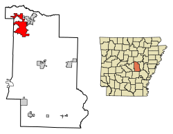
Location in Lonoke County, Arkansas
Usa edcp location map.svg
Red pog.svg
Cabot, Arkansas
Location in the United States
Coordinates: 34°58′22″N92°1′20″W / 34.97278°N 92.02222°W / 34.97278; -92.02222
Country United States
State Arkansas
County Lonoke
Founded1873
Incorporated 1891
Government
   Mayor Ken Kincade
Area
[1]
   City 20.78 sq mi (53.82 km2)
  Land20.68 sq mi (53.57 km2)
  Water0.10 sq mi (0.25 km2)
Elevation
299 ft (91 m)
Population
 (2020)
   City 26,569
  Density1,284.58/sq mi (495.99/km2)
   Metro
685,488 (Little Rock)
Time zone UTC-6 (CST)
  Summer (DST) UTC-5 (CDT)
ZIP code
72023
Area code 501
FIPS code 05-10300
GNIS feature ID0057487
Website www.cabotar.gov

Cabot is the largest city in Lonoke County, Arkansas, United States, and a suburb of Little Rock. As of the 2010 census, the population of the city was 23,776, [2] and in 2019 the population was an estimated 26,352, [3] ranking it as the state's 19th largest city, behind Jacksonville. It is part of the Little Rock North Little Rock Conway Metropolitan Statistical Area.

Contents

History

Prior to settlement

Before the city of Cabot existed, an 1862 typhoid epidemic took the lives of about 1,500 Confederate soldiers previously under Allison Nelson who were camped at Camp Nelson in the hills surrounding Cabot and Austin.[ citation needed ] In 1905, 428 poorly marked graves were exhumed by a group of Confederate veterans and moved to a new site at Camp Nelson Confederate Cemetery. Marble gravestones were placed over each grave and a large marble obelisk was erected to honor the dead. In 1982, a group of volunteers from Cabot began maintaining the cemetery, which had fallen into disrepair.[ citation needed ]

Early history

The city of Cabot sprang up as a small settlement around a refueling station on the Cairo & Fulton Railroad after it bypassed Austin. The settlement first appeared in 1873 and is thought to have been named after railroad executive George Cabot Ward.[ citation needed ] The First Baptist Church was established in 1876, and the Cabot United Methodist Church in 1881. G. W. Grandberry began publication of the first newspaper in 1885, named "The Guard". Grandberry, along with James Milton Park served as the towns medical doctors.[ citation needed ] By 1889 businesses began growing alongside the railroad tracks. Businesses included six general stores, two drugstores, a hotel owned by James Charles Boyd, James Adam's livery stable, and the Neely brothers cotton gin. [4] The Bank of Cabot (later merged into Centennial Bank) was founded in 1903. The city of Cabot was officially incorporated November 9, 1891, as the 139th city in Arkansas.

Cabot was often overshadowed in northern Lonoke County by what at the time was the much larger city of Austin (originally named Oakland). However, Cabot experienced growth during the 1950s and 1960s, due to its proximity to the Little Rock Air Force Base in nearby Jacksonville which opened in 1955, as well as due to the "white flight" occurring in response to the racial discord in Little Rock, Arkansas caused by school desegregation and its following crisis. [5]

Bedroom community

In 1972, the Little Rock School District, slow to comply with the 1954 US Supreme Court case Brown v. Topeka Board of Education , was forcibly ordered by federal courts to immediately desegregate the school district. As a result, tensions rose and during the 1980s and 1990s Little Rock school district teachers repeatedly went on strike.[ citation needed ] A "white exodus" occurred with many residents choosing to relocate to smaller communities around Little Rock, including Cabot, Benton, Bryant, Conway, and Maumelle instead of choosing to continue supporting full integration.[ citation needed ] Over time, new arrivals to the state chose to live in these towns (now veritable suburbs) because, by some educational indicators, the school districts were more successful.

Cabot received many of the families that were relocating during that time period. As a result, a "commuter culture" developed because many residents that had children in Cabot schools made the commute to Little Rock to work daily. 40% of military personnel working at the Little Rock Air Force Base in Jacksonville live in Cabot because of the higher cost of living in Little Rock and Jacksonville. [6] This, coupled with the perceived higher quality of life and easily accessed work opportunity, has resulted in a "boomtown." [7] As more people moved to Cabot to join the commuter culture, the tax base grew and, as a result, the Cabot School District steadily developed into one of the top-performing districts in the state.

Currently, the Cabot School District encompasses the north end of Lonoke County. The bulk of the county's population today can be found in approximately the same area, containing the county's most populous and second most populous cities — Cabot and Ward, respectively — in addition to Austin, which are among Arkansas' fastest growing communities. [8]

Recent history

Southward view of the Cabot Mini-Mall along First Street in downtown Cabot in December 2006 Cabot Arkansas.jpg
Southward view of the Cabot Mini-Mall along First Street in downtown Cabot in December 2006

A devastating tornado hit downtown Cabot during the afternoon of March 29, 1976, killing five people and destroying multiple buildings. [9] [10] During the rebuilding of the city, it was decided to build a new city hall, municipal courtroom, library (since relocated), and police station on the site of the debris-filled dividing point between the east and west sections of Main Street, creating City Plaza. Arkansas Highway 89, which follows the same path as West Main Street in Cabot, was redirected around City Plaza along one block of Second Street, to continue its path along Pine Street just south of the Cabot High School campus.

Cabot's population has more than quintupled from the 1980s to today, from under 5,000 residents to over 26,000. New housing starts, as seen by new subdivided developments, now cover the town.[ citation needed ]

On August 10, 2006, Cabot Junior High School North experienced a devastating fire which was believed to have started as a small electrical fire in the library caused by a faulty light bulb. Although there were 100 people in the building at the time, there were no injuries. [11] The building burned from 2:30 p.m. to about 9:00 p.m., and the structure was a total loss. Cabot Fire and Police Departments say that this is one of the worst structure fires to have ever occurred in Cabot. The school was only about eight years old. It was rebuilt and reopened about three years later. [12]

Highways and Transportation

Major transportation routes near/through Cabot are the railroad (currently owned by Union Pacific), the "old highway to St. Louis" (currently Arkansas Highway 367), and US Highway 67/167. Historically, Cabot lay on the Memphis to Fort Smith spur of the Butterfield Overland Stagecoach Route.

Geography

Cabot is in northwestern Lonoke County and is bordered to the northeast by the city of Austin. U.S. Routes 67 and 167 pass through the northwest side of the city on a four-lane freeway, leading northeast 26 miles (42 km) to Searcy and southwest 22 miles (35 km) to Little Rock, the state capital. Jacksonville is 9 miles (14 km) southwest of Cabot via Highways 67 and 167.

According to the United States Census Bureau, Cabot has a total area of 20.6 square miles (53.3 km2), of which 20.5 square miles (53.1 km2) are land and 0.1 square miles (0.2 km2), or 0.44%, are water. [2]

Climate

The climate in this area is characterized by hot, humid summers and generally mild to cool winters. According to the Köppen Climate Classification system, Cabot has a humid subtropical climate, abbreviated "Cfa" on climate maps. [13]

Climate data for Cabot, Arkansas, 1991–2020 normals, extremes 1965–present
MonthJanFebMarAprMayJunJulAugSepOctNovDecYear
Record high °F (°C)80
(27)
83
(28)
91
(33)
94
(34)
98
(37)
106
(41)
112
(44)
110
(43)
106
(41)
96
(36)
87
(31)
79
(26)
112
(44)
Mean maximum °F (°C)70.0
(21.1)
73.8
(23.2)
81.1
(27.3)
84.5
(29.2)
89.3
(31.8)
94.6
(34.8)
98.8
(37.1)
99.2
(37.3)
94.9
(34.9)
87.2
(30.7)
79.0
(26.1)
70.5
(21.4)
101.0
(38.3)
Mean daily maximum °F (°C)51.2
(10.7)
55.7
(13.2)
64.5
(18.1)
73.3
(22.9)
80.8
(27.1)
88.5
(31.4)
92.4
(33.6)
91.9
(33.3)
86.4
(30.2)
75.8
(24.3)
63.5
(17.5)
53.7
(12.1)
73.1
(22.9)
Daily mean °F (°C)39.6
(4.2)
43.3
(6.3)
51.7
(10.9)
60.2
(15.7)
69.2
(20.7)
77.3
(25.2)
80.8
(27.1)
79.9
(26.6)
73.6
(23.1)
61.8
(16.6)
50.5
(10.3)
42.3
(5.7)
60.9
(16.0)
Mean daily minimum °F (°C)27.9
(−2.3)
30.9
(−0.6)
39.0
(3.9)
47.1
(8.4)
57.5
(14.2)
66.1
(18.9)
69.2
(20.7)
67.9
(19.9)
60.7
(15.9)
47.9
(8.8)
37.5
(3.1)
30.9
(−0.6)
48.6
(9.2)
Mean minimum °F (°C)13.2
(−10.4)
17.5
(−8.1)
22.9
(−5.1)
32.7
(0.4)
42.4
(5.8)
55.6
(13.1)
61.5
(16.4)
59.5
(15.3)
46.1
(7.8)
31.7
(−0.2)
22.0
(−5.6)
16.5
(−8.6)
10.3
(−12.1)
Record low °F (°C)−5
(−21)
−3
(−19)
11
(−12)
24
(−4)
35
(2)
46
(8)
51
(11)
49
(9)
35
(2)
24
(−4)
11
(−12)
−7
(−22)
−7
(−22)
Average precipitation inches (mm)3.55
(90)
4.42
(112)
5.20
(132)
5.25
(133)
6.11
(155)
3.64
(92)
3.26
(83)
3.82
(97)
3.67
(93)
4.17
(106)
5.19
(132)
5.05
(128)
53.33
(1,353)
Average snowfall inches (cm)0.7
(1.8)
0.9
(2.3)
0.4
(1.0)
0.0
(0.0)
0.0
(0.0)
0.0
(0.0)
0.0
(0.0)
0.0
(0.0)
0.0
(0.0)
0.0
(0.0)
0.0
(0.0)
0.1
(0.25)
2.1
(5.35)
Average precipitation days (≥ 0.01 in)7.47.68.89.19.87.17.46.85.56.97.88.092.2
Average snowy days (≥ 0.1 in)0.40.50.30.00.00.00.00.00.00.00.10.11.4
Source 1: NOAA [14]
Source 2: National Weather Service [15]

Demographics

Historical population
CensusPop.Note
1880 154
1900 294
1910 44150.0%
1920 4471.4%
1930 68453.0%
1940 7418.3%
1950 1,14754.8%
1960 1,32115.2%
1970 2,903119.8%
1980 4,80665.6%
1990 8,31973.1%
2000 15,26183.4%
2010 23,77655.8%
2020 26,56911.7%
U.S. Decennial Census [16]

2020 census

Cabot racial composition [17]
RaceNumberPercentage
White (non-Hispanic)21,93682.56%
Black or African American (non-Hispanic)7612.86%
Native American 1220.46%
Asian 4461.68%
Pacific Islander 260.1%
Other/Mixed 1,7106.44%
Hispanic or Latino 1,5685.9%

As of the 2020 United States census, there were 26,569 people, 9,780 households, and 6,967 families residing in the city.

2010 census

As of the census of 2010, there were 23,776 people, 5,432 households, and 4,329 families residing in the city. The most recent United States Census Bureau estimates available (from July 2014) indicate the city's population at 25,627. The population density was 798.2 inhabitants per square mile (308.2/km2). There were 5,712 housing units at an average density of 298.8 per square mile (115.4/km2). The racial makeup of the city was 96.56% White, 0.33% Black or African American, 0.40% Native American, 0.88% Asian, 0.04% Pacific Islander, 0.49% from other races, and 1.30% from two or more races. 1.87% of the population were Hispanic or Latino of any race. [18]

There were 5,432 households, out of which 47.1% had children under the age of 18 living with them, 65.7% were married couples living together, 10.7% had a female householder with no husband present, and 20.3% were non-families. 17.2% of all households were made up of individuals, and 5.8% had someone living alone who was 65 years of age or older. The average household size was 2.78 and the average family size was 3.14.

In the city, the population was spread out, with 31.5% under the age of 18, 7.6% from 18 to 24, 34.0% from 25 to 44, 19.0% from 45 to 64, and 7.9% who were 65 years of age or older. The median age was 32 years. For every 100 females, there were 95.8 males. For every 100 females age 18 and over, there were 89.9 males.

The median income for a household in the city was $49,389, and the median income for a family was $53,933. Males had a median income of $37,450 versus $26,209 for females. The per capita income for the city was $19,020. About 5.6% of families and 7.1% of the population were below the poverty line, including 7.9% of those under age 18 and 10.4% of those age 65 or over.

Arts and culture

Cabot has a movie theater that was built in the late 1990s, plus a growing number of restaurants, amateur sporting venues and community organizations. A new multimillion-dollar library/public meeting complex was completed and opened in 2015. The city has golf courses adjoining Greystone Country Club in the city's north end, and near Rolling Hills Country Club in southeast Cabot. Both of the country clubs and the Veterans of Foreign Wars post are exceptions to Cabot's legal status as part of a dry county, which prohibits the sale of alcoholic beverages elsewhere in the city.

One of the city's biggest events, staged in the downtown area each October, is Cabotfest — a community fair that has grown in popularity as the city's population has swelled over the years since the tornado. A similar event called Strawberry Fest is held annually in the spring. Cabot is part of the small area in Arkansas along highway 67/167 where strawberries were grown in abundance and sold in other parts of the country during the early part of the 20th Century due in large part to the arrival of the railroad. [19]

Adam Richman, the host of Man vs. Food on the Travel Channel, came to Cabot's Mean Pig BBQ during the Season 2 "Little Rock" episode which aired on November 25, 2009, to try the Shut-Up Juice Challenge, which involves a large smoked pulled pork sandwich topped with coleslaw and "Shut-Up Juice" - barbecue sauce mixed with a tablespoon of concentrated, undiluted habanero extract. [20]

There are 43 churches in Cabot. [21] This gives the city a person-to-church ratio of 618 people per church.

Education

Cabot Public Schools serves students in the communities of Cabot, Austin, and Ward, as well as most of northern Lonoke County. [22] The Cabot Public School District has been designated as a Purple Star School District for its support of military families, particularly those serving at the Little Rock Air Force Base. [23]

Notable people

Related Research Articles

<span class="mw-page-title-main">Pulaski County, Arkansas</span> County in Arkansas, United States

Pulaski County is a county in the U.S. state of Arkansas. With a population of 399,125 as of the 2020 United States Census, it is the most populous county in Arkansas. The county is included in the Little Rock–North Little Rock–Conway metropolitan area. Its county seat is Little Rock, which is also Arkansas's capital and largest city.

<span class="mw-page-title-main">Lonoke County, Arkansas</span> County in Arkansas, United States

Lonoke County is located in the Central Arkansas region of the U.S. state of Arkansas. As of the 2020 census, the population was 74,015, making it the 10th-most populous of Arkansas's 75 counties. The county seat is Lonoke and largest city is Cabot. Included in the Central Arkansas metropolitan area, with Little Rock as the principal city, it is an alcohol prohibition or dry county.

<span class="mw-page-title-main">Stuttgart, Arkansas</span> City in Arkansas

Stuttgart is a city in and the county seat of the northern district of Arkansas County, Arkansas, United States. Established by German settlers, it was named for its larger German counterpart. Known as the "Rice and Duck Capital of the World", the city is an international destination for waterfowl hunting along the Mississippi Flyway. Stuttgart is the most important city on the Arkansas Grand Prairie, a region known for rice cultivation. The economy is largely based on agricultural production, waterfowl tourism, and supporting industries. As of the 2010 census it had a population of 9,326.

<span class="mw-page-title-main">Wynne, Arkansas</span> City in Arkansas, United States

Wynne is the county seat and largest city of Cross County, Arkansas, United States. The population was 8,314 at the 2020 Census. Nestled between the Arkansas Delta and Crowley's Ridge, Wynne is the closest city to the second-largest state park in Arkansas, Village Creek State Park.

<span class="mw-page-title-main">Malvern, Arkansas</span> City in Arkansas, United States

Malvern is a city in and the county seat of Hot Spring County, Arkansas, United States. Founded as a railroad stop at the eastern edge of the Ouachita Mountains, the community's history and economy have been tied to available agricultural and mineral resources. The production of bricks from locally available clay has earned the city the nickname, "The Brick Capital of the World". The city had a population of 10,318 at the time of the 2010 census, and in 2019 the estimated population was 10,931.

<span class="mw-page-title-main">Redfield, Arkansas</span> City in Arkansas, United States

For people with the surname, see Redfield (surname).

<span class="mw-page-title-main">Clarksville, Arkansas</span> City in Arkansas, United States

Clarksville is a city in Johnson County, Arkansas, United States. As of the 2010 census the population was 9,178, up from 7,719 in 2000. As of 2018, the estimated population was 9,743. The city is the county seat of Johnson County. It is nestled between the Arkansas River and the foothills of the Ozark Mountains, and Interstate 40 and US Highway 64 intersect within the city limits. Clarksville-Johnson County is widely known for its peaches, scenic byways and abundance of natural outdoor recreational activities.

<span class="mw-page-title-main">Austin, Arkansas</span> City in Arkansas, United States

Austin is a city in Lonoke County, Arkansas, United States. The population was 2,038 as of the 2010 census and an estimated 3,693 as of 2018. It is part of the Little Rock–North Little Rock–Conway Metropolitan Statistical Area.

<span class="mw-page-title-main">Carlisle, Arkansas</span> City in Arkansas, United States

Carlisle is a city in Lonoke County, Arkansas, United States. It is the easternmost municipality within the Little Rock–North Little Rock–Conway Metropolitan Statistical Area. Carlisle was incorporated in 1878. As of the 2010 census it had a population of 2,214.

<span class="mw-page-title-main">Keo, Arkansas</span> Town in Arkansas, United States

Keo is a town in southwest Lonoke County, Arkansas, United States. The population was 256 at the 2010 census. It is part of the Little Rock–North Little Rock–Conway Metropolitan Statistical Area.

<span class="mw-page-title-main">Lonoke, Arkansas</span> City in Arkansas, United States

Lonoke is the second most populous city in Lonoke County, Arkansas, United States, and serves as its county seat. According to 2010 United States Census, the population of the city is 4,245. It is part of the Little Rock–North Little Rock–Conway Metropolitan Statistical Area.

<span class="mw-page-title-main">Scott, Arkansas</span> Census-designated place in Arkansas, United States

Scott is an unincorporated community and census-designated place (CDP) in Lonoke and Pulaski counties in the central part of the U.S. state of Arkansas. Per the 2020 census, the population was 97. It is part of the Little Rock–North Little Rock–Conway Metropolitan Statistical Area.

<span class="mw-page-title-main">Ward, Arkansas</span> City in Arkansas, United States

Ward is the third most populous city in Lonoke County, Arkansas, United States. The population was 6,052 at the 2020 census. It is part of the Little Rock–North Little Rock–Conway Metropolitan Statistical Area.

<span class="mw-page-title-main">Brinkley, Arkansas</span> City in Arkansas, United States

Brinkley is the most populous city in Monroe County, Arkansas, United States. As of the 2020 census, the population was 2,700, down from 3,188 in 2010.

<span class="mw-page-title-main">Mena, Arkansas</span> City in Arkansas, United States

Mena is a city in Polk County, Arkansas, United States. It is also the county seat of Polk County. The population was 5,558 as of the 2020 census. Mena is included in the Ark-La-Tex socio-economic region. Surrounded by the Ouachita National Forest, Mena is a gateway to some of the most visited tourist attractions in Arkansas.

<span class="mw-page-title-main">Jacksonville, Arkansas</span> City in Arkansas, United States

Jacksonville is a city in Pulaski County, Arkansas, United States, and a suburb of Little Rock. As of the 2010 census, the population of the city was 28,364. It is part of the Little Rock–North Little Rock–Conway Metropolitan Statistical Area with 729,135 people as of 2014.

<span class="mw-page-title-main">Sherwood, Arkansas</span> City in Arkansas, United States

Sherwood is a city in Pulaski County, Arkansas, United States. As of the 2020 census, the population of the city was 32,731, making it the 13th most populous city in Arkansas. It is part of the Little Rock−North Little Rock−Conway Metropolitan Statistical Area with 699,757 people according to the 2010 census.

<span class="mw-page-title-main">Beebe, Arkansas</span> City in Arkansas, United States

Beebe is a city in White County, Arkansas, United States. The population was 7,315 at the 2010 U.S. Census, making it the second most populous in the county. The city is home to Arkansas State University-Beebe. ASU-Beebe also has branch campuses in Heber Springs and Searcy and at Little Rock Air Force Base.

<span class="mw-page-title-main">Central Arkansas</span> Metropolitan area in Arkansas, United States

Central Arkansas, also known as the Little Rock metro, designated by the United States Office of Management and Budget as the Little Rock-North Little Rock-Conway Metropolitan Statistical Area, is the most populous metro area in the U.S. state of Arkansas. With an estimated 2020 population of 748,031, it is the most populated area in Arkansas. Located at the convergence of Arkansas's other geographic regions, the region's central location make Central Arkansas an important population, economic, education, and political center in Arkansas and the South. Little Rock is the state's capital and largest city, and the city is also home to two Fortune 500 companies, Arkansas Children's Hospital, and University of Arkansas for Medical Sciences (UAMS).

<span class="mw-page-title-main">Romance, Arkansas</span> Unincorporated community in Arkansas, United States

Romance is an unincorporated community in west-central White County, Arkansas, United States. The community is located approximately halfway between the town of Rose Bud to the north, and the unincorporated community of El Paso to the south. Alternately, the community is about 16 miles (26 km) northwest of Beebe, and less than 5 miles (8 km) east of Mount Vernon.

References

  1. "2020 U.S. Gazetteer Files". United States Census Bureau. Retrieved October 29, 2021.
  2. 1 2 "Geographic Identifiers: 2010 Census Summary File 1 (G001), Cabot city, Arkansas". American FactFinder. U.S. Census Bureau. Archived from the original on February 13, 2020. Retrieved August 29, 2019.
  3. "Population and Housing Unit Estimates" . Retrieved May 21, 2020.
  4. Polston, Mike, and Debra Carrington Polston. Cabot. Charleston, SC: Arcadia Publishing, 2012.
  5. Polston, Mike, ed. Bits and Pieces of Cabot History. Vol. 1. Cabot: Magee Publishing, 1988.
  6. Nix, Ryan (December 4, 2019). "Cabot: 'Commuter Town' Bursting With Potential". AMP. Retrieved August 13, 2023.
  7. Tucker, Tyler. “Cabot Regarded as State’s Only Boomtown.” Cabot-Star Herald. February 11, 2009, pp. 1A, 7A.
  8. "Arkansas Population Growth Rate City Rank". www.usa.com. Retrieved July 22, 2023.
  9. "Looking back: 40 years after devastating Cabot tornado". www.arkansasonline.com. Retrieved July 22, 2023.
  10. "Tornadoes Strike In South". The New York Times. March 30, 1976. ISSN   0362-4331 . Retrieved July 22, 2023.
  11. Sabin, Warwick (August 11, 2006). "Fire at Cabot junior high school". Arkansas Times. Retrieved July 22, 2023.
  12. "CABOT JUNIOR HIGH NORTH REBUILT: Up from the ashes". Arkansas Online. September 3, 2009. Retrieved July 22, 2023.
  13. "Cabot, Arkansas Köppen Climate Classification (Weatherbase)". Weatherbase.
  14. "U.S. Climate Normals Quick Access – Station: Cabot, AR". National Oceanic and Atmospheric Administration. Retrieved February 24, 2023.
  15. "NOAA Online Weather Data – NWS Little Rock". National Weather Service. Retrieved February 24, 2023.
  16. "Census of Population and Housing". Census.gov. Retrieved June 4, 2015.
  17. "Explore Census Data". data.census.gov. Retrieved December 31, 2021.
  18. "U.S. Census website". United States Census Bureau . Retrieved January 31, 2008.
  19. "Encyclopedia of Arkansas". Encyclopedia of Arkansas. Retrieved August 13, 2023.
  20. "Man vs Food Little Rock ARKANSAS / AR Challenge Locations". manvsfoodlocations.com.
  21. "Churches in Cabot Arkansas - ChurchFinder.com". Church Finder. Retrieved July 20, 2023.
  22. U.S. Census Bureau. "2020 Census School District Reference Map: Lonoke County, AR" (PDF). Retrieved July 20, 2023.
  23. "Support For Military Families". Cabot Public Schools. Retrieved July 20, 2023.
  24. "3D-printed gun designer Cody Wilson gets probation in child sexual assault case". September 12, 2019.