This article relies largely or entirely on a single source .(January 2023) |
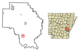
Sylvania, Arkansas is an unincorporated community located in Lonoke County, Arkansas, United States. [1]
This article relies largely or entirely on a single source .(January 2023) |
Sylvania, Arkansas is an unincorporated community located in Lonoke County, Arkansas, United States. [1]

Sylvania is a town in DeKalb County, Alabama, United States. It incorporated in October 1967. At the 2010 census the population was 1,837, up from 1,186 in 2000. Sylvania is located atop Sand Mountain. Sylvania has its own Post Office, established in 1996 and located at 9596 Blue Pond Blvd. W.

Almyra is a town in Arkansas County, Arkansas, United States. The population was 283 at the 2010 census.
Gillett is a city in Arkansas County, Arkansas, United States. Its population was 691 at the 2010 census. Gillett is the home of the annual Gillett Coon Supper. The Arkansas Post National Memorial is located southeast of the town.
Fisher is a city in Poinsett County, Arkansas, United States. The population was 223 at the 2010 census. It is included in the Jonesboro, Arkansas Metropolitan Statistical Area.

DeValls Bluff is a city in and the county seat of the southern district of Prairie County, Arkansas, United States. The population was 619 at the 2010 census.

Sylvania is a town in and the county seat of Screven County, Georgia, United States. The population was 2,956 at the 2010 census.

Christopher is a city in Franklin County, Illinois, United States. The population was 2,697 at the time of the 2020 census.

Utica is a census-designated place (CDP) in Oconee County, South Carolina, United States. The population was 1,322 at the 2000 census.
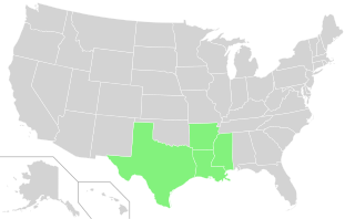
The Rice Belt of the United States includes Arkansas, Louisiana, Mississippi and Texas, four southern U.S. states that grow a significant portion of the nation's rice crop. The name is in conformity with the Corn Belt of the Midwestern United States, in which much of the nation's corn is grown.
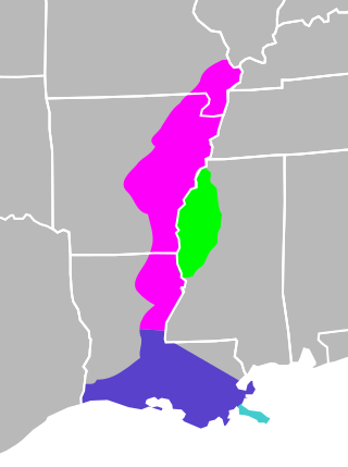
The Mississippi River Alluvial Plain is an alluvial plain created by the Mississippi River on which lie parts of seven U.S. states, from southern Louisiana to southern Illinois.
Border irregularities of the United States, particularly panhandles and highway incursions into other jurisdictions, are shown here. Often they are a result of borders which do not conform to geological features such as changes in the course of a river that previously marked a border.

The Fifth principal meridian, often denoted the "5th Meridian" or "PM 05," is a principal meridian survey line used in the United States for land claims in the Public Land Survey System (PLSS). It was first surveyed in 1815. The meridian, a north-south line, starts from the old mouth of the Arkansas River and runs north. Another survey line related to it is the base line running west from the old mouth of the St. Francis River. These survey lines govern all land surveys in four states and a large portion of the land surveys for two more. Monuments have been erected where the two lines meet at 34°38′44″N91°3′42″W, and the surveyors' skill has been commemorated at the Louisiana Purchase State Park in eastern Arkansas. The Fifth principal meridian is nearly coincident with 91° 3′ 42″ longitude west from the Greenwich meridian.
Hobart Township is a civil township in Barnes County, North Dakota, United States. As of the 2000 census, its population was 149.
Dueling Creek is a tributary of the Anacostia River in southern Maryland in the United States, located in the town of Colmar Manor.
Crocketts Bluff is an unincorporated community in Arkansas County, Arkansas, United States. It is the location of Crocketts Bluff Hunting Lodge, which is located at the end of the dirt road north of the point at which AR 153 turns south, and is listed on the National Register of Historic Places. Crocketts Bluff sits at the highest point in Arkansas County. The ZIP Code for Crocketts Bluff is 72038.
Tichnor is an unincorporated community in Arkansas County, Arkansas, United States. It is the location of the Tichnor Rice Dryer and Storage Building, and is the nearest community to the Roland Site, both listed on the National Register of Historic Places. The ZIP Code for Tichnor is 72166.

Bartholomew Township is a township in Lincoln County, Arkansas, United States. Its total population was 687 as of the 2010 United States Census, a decrease of 19.84 percent from 857 at the 2000 census.
Aberdeen is a populated place in Monroe County, Arkansas, United States. The nearest communities are Roe also in Monroe County, approximately 3 miles (4.8 km) to the northwest, Casscoe in Arkansas County approximately 5 miles (8.0 km) to the southeast and Preston Ferry in Arkansas County, approximately 5 miles (8.0 km) to the south.
Retreat is an unincorporated community in West Feliciana Parish, Louisiana, United States.
Bogy Township is a township in Jefferson County, in the U.S. state of Arkansas. The township was established in 1854. Its population was 54 as of the 2020 census.
Municipalities and communities of Lonoke County, Arkansas, United States | ||
|---|---|---|
| Cities |  | |
| Towns | ||
| CDP | ||
| Unincorporated communities | ||
| Footnotes | ‡This populated place also has portions in an adjacent county or counties | |
34°58′20″N91°55′43″W / 34.97222°N 91.92861°W
| | This article about a location in Lonoke County, Arkansas is a stub. You can help Wikipedia by expanding it. |