Southwest Trail

Last updated
Map showing the Southwest Trail or Military Road as it was in the mid-1800s (in red) and the Natchitoches Trace that it replaced (in brown). Southwesttrailmap.png
Map showing the Southwest Trail or Military Road as it was in the mid-1800s (in red) and the Natchitoches Trace that it replaced (in brown).

The Southwest Trail was a 19th-century pioneer route that was the primary passageway for American settlers bound for Texas.

Contents

History

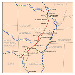
The Southwest Trail, also known as the Old Military Road, replaced the older Natchitoches Trace, which ran from the mouth of the Missouri River, near present-day St. Louis, Missouri to present-day Fulton, Arkansas on the Red River. From Fulton, another American Indian trace followed the Red River to Natchitoches, Louisiana. [1] [2]

Southwest Trail was a general term for a network of trails linking St. Louis and Ste-Geneviève, Missouri to the Red River Valley of Texas. European American pioneers improved and expanded the older route. At the time of Americans' first settling the Texas territory, the Red River was the border between Mexico and the United States.

Little more than a footpath before Arkansas became a territory in 1819, Southwest Trail became a major immigration route in the 1820s. By the 1830s more than 80 percent of the Arkansas territory's population had entered through the Southwest Trail. The U.S. Army improved the military road during Andrew Jackson’s presidency.

Usage of the trail north of the Arkansas River declined in the late 1800s, but the trail south of the river remained in use decades longer. [3]

Route

From the St. Louis and Ste-Geneviève areas, the trail passed through Wayne County, Missouri. The Indian trace was the southern route of two followed by Cherokees and their enslaved Africans during the Trail of Tears. [2]

From its origin as a footpath, to a series of rugged roads, highways follow much of the route today. Southwest Trail enters Arkansas on Arkansas Highway 166, north of Maynard, (Randolph County). It then passes through communities of Attica, Pocahontas, Imboden, Smithville, Jesup, Strawberry and Walnut Grove.

Two routes were used by pioneers en route to Southside. The older, eastern trail passes through Davidsonville, Newark and Oil Trough. Davidsonville was a pioneer key town on the Black River, but frequent flooding led to use of a newer, western route that passes through Sulphur Rock and crosses the White River at Batesville. [4]

From Southside, the trail follows U.S. Route 167 to Pleasant Plains, then Arkansas Highway 157 to Sunnydale, then Arkansas Highway 124 to Arkansas Highway 305 to Arkansas Highway 16 to Letona Road to Mount Pisgah Road to Morris School Road to Arkansas Highway 36 to Center Hill, then Arkansas Highway 305 to Floyd, then El Paso Road to Arkansas Highway 5 through El Paso to Arkansas Highway 89, then Tate's Mill Road to Batesville Pike Road through Gibson to Remount Road to Arkansas Highway 176 to Arkansas Highway 365 through North Little Rock.

Southwest Trail crosses the Arkansas River on U.S. Route 70, through Little Rock to Arkansas Highway 5 through Bryant and Benton to U.S. Route 70, then Arkansas Highway 229 to U.S. Route 67. At Fairplay it takes Old Military Road to Rockport, where pioneers forded the Ouachita River.

From Rockport it takes Arkansas Highway 84 to Social Hill, then Old Military Road to U.S. Route 67 at Midway, to Caddo Valley, then crosses the Caddo River on Arkansas Highway 7 to Old Military Road, to Arkansas Highway 8 then Mount Olive Road to Hollywood, then Arkansas Highway 26 to Antoine, then Arkansas Highway 29 to Arkansas Highway 19, returns to Arkansas Highway 29 through Blevins, to Arkansas Highway 32, then U.S. Route 278 to Washington. It then follows Arkansas Highway 195 to Fulton, and crosses the Red River on U.S. Route 67. It continues to Mandeville, turns off on Rondo Road to Rondo, then takes U.S. Route 82 west to the current Arkansas-Texas border of Texarkana. [3]

The trail is commemorated in the Historic Washington State Park, northwest of Hope. Washington was a key trading point near the southwest end of the trail. [5]

Related Research Articles

U.S. Route 66 or U.S. Highway 66, also known as the Will Rogers Highway, the Main Street of America or the Mother Road, was one of the original highways in the U.S. Highway System. US 66 was established on November 11, 1926, with road signs erected the following year. The highway, which became one of the most famous roads in the United States, originally ran from Chicago, Illinois, through Missouri, Kansas, Oklahoma, Texas, New Mexico, and Arizona before ending in Santa Monica in Los Angeles County, California, covering a total of 2,448 miles (3,940 km). It was recognized in popular culture by both the hit song "(Get Your Kicks on) Route 66" and the Route 66 television series, which aired on CBS from 1960 to 1964. In John Steinbeck's classic American novel, The Grapes of Wrath (1939), the road "Highway 66" symbolized escape and loss.

Randolph County, Arkansas U.S. county in Arkansas

Randolph County is located between the Ozark Mountains and Arkansas Delta in the U.S. state of Arkansas. The county is named for John Randolph, a U.S. senator from Virginia influential in obtaining congressional approval of the Louisiana Purchase, which includes today's Randolph County. Created as Arkansas's 32nd county on October 29, 1835, Randolph County has two incorporated cities, including Pocahontas, the county seat and most populous city. The county is also the site of numerous unincorporated communities and ghost towns.

U.S. Route 61 Highway in the United States

U.S. Route 61 or U.S. Highway 61 (US 61) is a major United States highway which extends 1,400 miles (2,300 km) between New Orleans, Louisiana and the city of Wyoming, Minnesota. The highway generally follows the course of the Mississippi River, and is designated the Great River Road for much of its route. As of 2004, the highway's northern terminus in Wyoming, Minnesota, is at an intersection with Interstate 35 (I-35). Until 1991, the highway extended north on what is now Minnesota State Highway 61 through Duluth to the Canada–U.S. border near Grand Portage. Its southern terminus in New Orleans is at an intersection with U.S. Route 90. The route was an important south-north connection in the days before the interstate highway system.

Ark-La-Tex Region

The Ark-La-Tex is a socio-economic tri-state region where the Southern U.S. states of Arkansas, Louisiana, and Texas abut. The region contains portions of Northwest Louisiana, Northeast Texas, and South Arkansas as well as the extreme southeastern tip of Oklahoma, partly centered upon the Red River, which flows along the Texas–Oklahoma state line into Southwestern Arkansas and Northwest Louisiana.

Historic Washington State Park

Historic Washington State Park is a 101-acre (41 ha) Arkansas state park in Hemsptead County, Arkansas in the United States. The museum village contains a collection of pioneer artifacts from the town of Washington, Arkansas, which is a former pioneer settlement along the Southwest Trail. Walking interpretive tours are available throughout the 54 buildings. Washington served as a major trading point along the Southwest Trail, evolving into the Hempstead county seat and later the capital of Arkansas from 1863 to 1865 when Little Rock was threatened during the Civil War. The original plat of Washington was added to the National Register of Historic Places in 1972 as the Washington Historic District.

The Jefferson Highway was an automobile highway stretching through the central United States from New Orleans, Louisiana, to Winnipeg, Manitoba, Canada. The Jefferson Highway was replaced with the new numbered US Highway system in the late 1920s. Portions of the highway are still named Jefferson Highway, for example: the portions that run through Jefferson Parish, Louisiana; East Baton Rouge Parish, Louisiana; Lee's Summit, Missouri; Osseo, Minnesota; and Wadena, Minnesota.

U.S. Route 50 Highway in the United States

U.S. Route 50 or U.S. Highway 50 (US 50) is a major east–west route of the U.S. Highway system, stretching just over 3,000 miles (4,800 km) from Interstate 80 (I-80) in West Sacramento, California, to Maryland Route 528 in Ocean City, Maryland, on the Atlantic Ocean. Until 1972, when it was replaced by Interstate Highways west of the Sacramento area, it extended to San Francisco, near the Pacific Ocean. The Interstates were constructed later and are mostly separate from this route. It generally serves a corridor south of I-70 and I-80 and north of I-64 and I-40. The route runs through mostly rural desert and mountains in the western United States, with the section through Nevada known as "The Loneliest Road in America". In the Midwest, US 50 heads through mostly rural areas of farms as well as a few large cities including Kansas City, Missouri; St. Louis, Missouri; and Cincinnati, Ohio. The route continues into the eastern United States, where it passes through the Appalachian Mountains in West Virginia before heading through Washington, D.C. From there, US 50 continues through Maryland as a high-speed road to Ocean City. Signs at each end give the length as 3,073 miles (4,946 km), but the actual distance is slightly less, due to realignments since the former figure was measured. US 50 passes through a total of 12 states; California, Nevada, Utah, Colorado, Kansas, Missouri, Illinois, Indiana, Ohio, West Virginia, Virginia, and Maryland, as well as the District of Columbia.

U.S. Route 67 Highway in the United States

U.S. Route 67 is a major north–south U.S. highway which extends 1,560-mile-long (2,511 km) in the Central United States. The southern terminus of the route is at the United States-Mexico border in Presidio, Texas, where it continues south as Mexican Federal Highway 16 upon crossing the Rio Grande. The northern terminus is at U.S. Route 52 in Sabula, Iowa.

U.S. Route 71 US highway that goes from Ontario, Canada to Louisiana, United States

U.S. Route 71 or U.S. Highway 71 is a major north–south United States highway that extends for over 1500 miles in the central United States. This original 1926 route has remained largely unchanged by encroaching Interstate highways. Currently, the highway's northern terminus is in International Falls, Minnesota at the Canada–US border, at the southern end of the Fort Frances-International Falls International Bridge to Fort Frances, Ontario. U.S. Route 53 also ends here. On the other side of the bridge, Trans-Canada Highway is an east–west route while Highway 71 is a north–south route. US 71's southern terminus is between Port Barre and Krotz Springs, Louisiana at an intersection with U.S. Route 190. For the entirety south of Kansas City, Missouri, US 71 runs parallel and concurrent with the existing and future Interstate 49. North of Kansas City, US 71 runs halfway between Interstate 29 and Interstate 35, which they split in the city at an interchange with Interstate 70.

Santa Fe Trail Transportation route through central North America that connected Franklin, Missouri with Santa Fe, New Mexico.

The Santa Fe Trail was a 19th-century route through central North America that connected Franklin, Missouri with Santa Fe, New Mexico. Pioneered in 1821 by William Becknell, who departed from the Boonslick region along the Missouri River, the trail served as a vital commercial highway until the introduction of the railroad to Santa Fe in 1880. Santa Fe was near the end of the El Camino Real de Tierra Adentro, which carried trade from Mexico City.

There are many historic trails and roads in the United States which were important to the settlement and development of the United States including those used by American Indians.

El Paso, Arkansas An unincorporated community in southwestern White County, Arkansas

El Paso is an unincorporated community in southwestern White County, Arkansas, United States. Its name is Spanish for "the pass", referring to a small gap in the hills on the community's northern edge. Once known as Peach Orchard Gap in its early settlement, the origin of El Paso's Spanish name is unknown.

Louisiana Highway 6 highway in Louisiana

Louisiana Highway 6 (LA 6) is a state highway located in western central Louisiana. It runs 54.52 miles (87.74 km) in an east–west direction from the Texas state line southwest of Many to U.S. Highway 71 (US 71) and U.S. Highway 84 (US 84) in Clarence.

Davidsonville Historic State Park

Davidsonville Historic State Park is a 163-acre (66 ha) Arkansas state park in Randolph County, Arkansas in the United States. Situated on a border between The Ozarks and the Arkansas Delta, the park preserves the remains of the abandoned frontier town of Davidsonville. The town was one of Arkansaw Territory's first settlements when founded in 1815, serving as an important river port town on the Black River. The former townsite was made into a state park in 1957 and a monument was added to the National Register of Historic Places in 1974.

Victory Highway auto trail

The Victory Highway was an auto trail across the United States between New York City and San Francisco, roughly equivalent to the present U.S. Route 40. It was created by the Victory Highway Association, which was organized in 1921 to locate and mark a transcontinental highway to be dedicated to American forces who died in World War I. A series of Victory Eagle sculptures would mark the route, although only six were completed.

U.S. Route 67 is a U.S. highway running from Presidio, Texas northeast to Sabula, Iowa. In the U.S. state of Arkansas, the route runs 279.15 miles (449.25 km) from the Texas border in Texarkana northeast to the Missouri border near Corning. The route passes through several cities and towns, including Hope, Benton, Little Rock, Jacksonville, Cabot, Beebe, Walnut Ridge, and Pocahontas.

Arkansas Highway 166 highway in Arkansas

Arkansas Highway 166 is a designation for two state highways in Randolph County, Arkansas. The southern segment of 7.97 miles (12.83 km) runs from Old Davidsonville State Park to Pocahontas. A northern segment of 14.57 miles (23.45 km) runs north from US 62/US 67 to the Missouri state line.

U.S. Route 62 in Arkansas section of U.S. Highway in Arkansas, United States

U.S. Route 62 is a U.S. highway running from El Paso, Texas northeast to Niagara Falls, New York. In the U.S. state of Arkansas, the route runs 329.9 miles from the Oklahoma border near Summers east to the Missouri border in St. Francis, serving the northern portion of the state. The route passes through several cities and towns, including Fayetteville, Springdale, Bentonville, Harrison, Mountain Home, Pocahontas, and also Piggott. US 62 runs concurrent with several highways in Arkansas including Interstate 49 and U.S. Route 71 between Fayetteville and Bentonville, U.S. Route 412 through much of the state, U.S. Route 65 in the Harrison area, and with U.S. Route 63 and U.S. Route 67 in northeast Arkansas.

The Natchitoches Trace was a prehistoric American Indian path that led from the mouth of the Missouri River to present-day Natchitoches, Louisiana. Natchitoches Trace was superseded by the Southwest Trail in historical times.

Arkansas Highway 51 United States historic place

Highway 51 is a designation for two north–south state highways in Southwest Arkansas. One route of 53.37 miles (85.89 km) begins Highway 53 near Whelen Springs and runs north to US Highway 67 in Donaldson. A second route of 7.92 miles (12.75 km) runs parallel to US 270 northwest of Malvern. Both routes are maintained by the Arkansas Department of Transportation (ArDOT).

References

  1. "Natchitoches Trace and Old Military Road". Natchitoches Trace and Old Military Road. Retrieved January 26, 2016.
  2. 1 2 "Trail of Tears in Wayne County". Trail of Tears. St. Louis Community College-Meramec. Retrieved January 26, 2016.
  3. 1 2 "Southwest Trail". Arkansas Heritage Trail. Arkansas Department of Parks and Tourism. Retrieved January 25, 2016.
  4. "Davidsonville". Davidsonville. Encyclopedia of Arkansas. Retrieved January 27, 2016.
  5. "Historic Washington State Park" (PDF). Historic Washington State Park. Arkansas Department of Parks and Tourism. Retrieved January 26, 2016.