Sulphur Rock, Arkansas

Last updated

Sulphur Rock, Arkansas
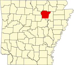
Independence County Arkansas Incorporated and Unincorporated areas Sulphur Rock Highlighted 0567730.svg
Location of Sulphur Rock in Independence County, Arkansas
Coordinates: 35°45′09″N91°30′03″W / 35.75250°N 91.50083°W / 35.75250; -91.50083
Country United States
State Arkansas
County Independence
Area
[1]
  Total1.25 sq mi (3.24 km2)
  Land1.25 sq mi (3.24 km2)
  Water0.00 sq mi (0.00 km2)
Elevation
[2]
325 ft (99 m)
Population
 (2020)
  Total609
  Density487.20/sq mi (188.07/km2)
Time zone UTC-6 (Central (CST))
  Summer (DST) UTC-5 (CDT)
ZIP code
72579
Area code 870
FIPS code 05-67730
GNIS feature ID2406680 [2]

Sulphur Rock is a town in Independence County, Arkansas, United States. The population was 456 at the 2010 census. [3]

Contents

Geography

Sulphur Rock is located approximately six miles east of Batesville along Arkansas Highway 69 and about four miles north of the White River. Magness and Newark lie about four and six miles respectively to the southeast along Route 69. [4]

According to the United States Census Bureau, the town has a total area of 1.3 square miles (3.3 km2), all land. [3]

List Of Highways

History

The last regular mule-drawn tram line in the United States was in Sulphur Rock, closing down in 1926.[ citation needed ]

Demographics

Historical population
CensusPop.Note
1880 188
1890 387105.9%
1900 213−45.0%
1910 25218.3%
1920 227−9.9%
1930 177−22.0%
1940 1812.3%
1950 179−1.1%
1960 22525.7%
1970 29028.9%
1980 3169.0%
1990 35612.7%
2000 42118.3%
2010 4568.3%
2020 60933.6%
U.S. Decennial Census [5]

As of the census [6] of 2000, there were 421 people, 169 households, and 113 families residing in the town. The population density was 127.0/km2 (328.6/mi2). There were 178 housing units at an average density of 53.7/km2 (138.9/mi2). The racial makeup of the town was 97.39% White, and 2.61% from two or more races. 2.14% of the population were Hispanic or Latino of any race.

There were 169 households, out of which 28.4% had children under the age of 18 living with them, 56.8% were married couples living together, 8.3% had a female householder with no husband present, and 33.1% were non-families. 29.6% of all households were made up of individuals, and 21.3% had someone living alone who was 65 years of age or older. The average household size was 2.49 and the average family size was 3.09.

In the town, the population was spread out, with 25.9% under the age of 18, 9.3% from 18 to 24, 24.5% from 25 to 44, 23.8% from 45 to 64, and 16.6% who were 65 years of age or older. The median age was 38 years. For every 100 females, there were 95.8 males. For every 100 females age 18 and over, there were 91.4 males.

The median income for a household in the town was $30,000, and the median income for a family was $37,375. Males had a median income of $25,417 versus $17,426 for females. The per capita income for the town was $13,309. About 6.3% of families and 10.6% of the population were below the poverty line, including 9.6% of those under age 18 and 31.3% of those age 65 or over.

Education

Batesville School District serves the community. Sulphur Rock School District consolidated into the Batesville district on July 1, 2005. [7]

Related Research Articles

<span class="mw-page-title-main">Independence County, Arkansas</span> County in Arkansas, United States

Independence County is a county located in the U.S. state of Arkansas. As of the 2020 census, the population was 37,938. The county seat is Batesville. Independence County is Arkansas's ninth county, formed on October 20, 1820, from a portion of Lawrence County and named in commemoration of the Declaration of Independence. It is an alcohol prohibition or dry county.

<span class="mw-page-title-main">Valley Springs, Arkansas</span> Town in Arkansas, United States

Valley Springs is a town in Boone County, Arkansas, United States. The population was 175 at the 2010 census. It is part of the Harrison Micropolitan Statistical Area.

<span class="mw-page-title-main">Oak Grove, Carroll County, Arkansas</span> Town in Arkansas, United States

Oak Grove is a town in Carroll County, Arkansas, United States. The population was 386 at the 2020 census.

<span class="mw-page-title-main">Concord, Arkansas</span> Town in Arkansas, United States

Concord is a town in Cleburne County, Arkansas, United States. The population was 244 at the 2010 census.

<span class="mw-page-title-main">Batesville, Arkansas</span> City in Arkansas, United States

Batesville is the county seat and largest city of Independence County, Arkansas, United States, 80 miles (183 km) northeast of Little Rock, the state capital. According to the 2010 Census, the population of the city was 10,268. The city serves as a regional manufacturing and distribution hub for the Ozark Mountain region and Northeast Arkansas.

<span class="mw-page-title-main">Cushman, Arkansas</span> City in Arkansas, United States

Cushman is a city in Independence County, Arkansas, United States. The population was 433 at the 2020 census.

<span class="mw-page-title-main">Magness, Arkansas</span> Town in Arkansas, United States

Magness is a town in Independence County, Arkansas, United States. The population was 202 at the 2010 census. The mayor is Jerrit Pectol.

<span class="mw-page-title-main">Moorefield, Arkansas</span> Town in Arkansas, United States

Moorefield is a town in Independence County, Arkansas, United States. It was named after Jesse A. Moore who owned most of the land in the area of the town at that time. The population was 137 at the 2010 census.

<span class="mw-page-title-main">Mount Pleasant, Arkansas</span> Town in Arkansas, United States

Mount Pleasant is a town in Izard County, Arkansas, United States. As of the 2020 census, the town population was 353.

<span class="mw-page-title-main">Pineville, Arkansas</span> Town in Arkansas, United States

Pineville is a town in Izard County, Arkansas, United States. The population was 238 at the 2010 census.

<span class="mw-page-title-main">Jacksonport, Arkansas</span> Town in Arkansas, United States

Jacksonport is a town in Jackson County, Arkansas, United States, along the White River at its confluence with the Black River. The population was 212 at the 2010 census.

<span class="mw-page-title-main">Weldon, Arkansas</span> Town in Arkansas, United States

Weldon is a town in Jackson County, Arkansas, United States. The population was 75 at the 2010 census.

<span class="mw-page-title-main">Powhatan, Arkansas</span> Town in Arkansas, United States

Powhatan is a town in Lawrence County, Arkansas, United States, along the Black River. The population was 72 at the 2010 census, up from 50 at the 2000 census.

<span class="mw-page-title-main">Strawberry, Arkansas</span> Town in Arkansas, United States

Strawberry is a town in Lawrence County, Arkansas, United States. The population was 302 at the 2010 census.

<span class="mw-page-title-main">Rondo, Arkansas</span> Town in Arkansas, United States

Rondo is a town in Lee County, Arkansas, United States. The population was 198 at the 2010 census, down from 237 at the 2000 census.

<span class="mw-page-title-main">Coy, Arkansas</span> Town in Arkansas, United States

Coy is a town in southern Lonoke County, Arkansas, United States. The population was 96 at the 2010 census, making it the smallest incorporated community within the Little Rock–North Little Rock–Conway Metropolitan Statistical Area, as well as one of the smallest in the state.

<span class="mw-page-title-main">Garland, Arkansas</span> Town in Arkansas, United States

Garland, also known as Garland City, is a town in Miller County, Arkansas, United States. It is part of the Texarkana, Texas - Texarkana, Arkansas Metropolitan Statistical Area. The population was 195 at the 2020 census, down from 242 in 2010.

<span class="mw-page-title-main">Marie, Arkansas</span> Town in Arkansas, United States

Marie is a town in Mississippi County, Arkansas, United States. It was founded by the R.E.L. Wilson cotton company. The population was 108 at the 2020 census.

<span class="mw-page-title-main">Victoria, Arkansas</span> Town in Arkansas, United States

Victoria is a town in Mississippi County, Arkansas, United States. The population was 20 as of the 2020 census, down from 37 in 2010. It is named after a sister of the town's founder, Robert E. Lee Wilson.

<span class="mw-page-title-main">Rosston, Arkansas</span> Town in Arkansas, United States

Rosston is a town in south-central Nevada County, Arkansas, United States. The population was 265 at the 2000 census. It is part of the Hope Micropolitan Statistical Area.

References

  1. "2020 U.S. Gazetteer Files". United States Census Bureau. Retrieved October 29, 2021.
  2. 1 2 U.S. Geological Survey Geographic Names Information System: Sulphur Rock, Arkansas
  3. 1 2 "Geographic Identifiers: 2010 Census Summary File 1 (G001): Sulphur Rock town, Arkansas". American Factfinder. U.S. Census Bureau. Archived from the original on February 13, 2020. Retrieved March 23, 2018.
  4. Sulfur Rock, AR, 7.5 Minute Topographic Quadrangle, USGS, 1943 (1981 rev.)
  5. "Census of Population and Housing". Census.gov. Retrieved June 4, 2015.
  6. "U.S. Census website". United States Census Bureau . Retrieved January 31, 2008.
  7. "ConsolidationAnnex_from_1983.xls Archived 2015-09-12 at the Wayback Machine ." Arkansas Department of Education. Retrieved on October 13, 2017.