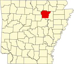
Salado, Arkansas | |
---|---|
Coordinates: 35°41′43″N91°35′32″W / 35.69528°N 91.59222°W | |
Country | United States |
State | Arkansas |
County | Independence |
Elevation | 449 ft (137 m) |
Population (2020) | |
• Total | 472 |
Time zone | UTC-6 (Central (CST)) |
• Summer (DST) | UTC-5 (CDT) |
GNIS feature ID | 2805683 [1] |
Salado is an Incorporated community and census-designated place (CDP) in Independence County, Arkansas, United States. [1] It was first listed as a CDP in the 2020 census with a population of 472. [2]
The Goff Petroglyph Site is located here. [3]
The spur route of Arkansas Highway 14 connects Salado with Southside. [4]
Census | Pop. | Note | %± |
---|---|---|---|
2020 | 472 | — | |
U.S. Decennial Census [5] 2020 [6] |
Race / Ethnicity | Pop 2020 [6] | % 2020 |
---|---|---|
White alone (NH) | 404 | 85.59% |
Black or African American alone (NH) | 5 | 1.06% |
Native American or Alaska Native alone (NH) | 1 | 0.21% |
Asian alone (NH) | 2 | 0.42% |
Pacific Islander alone (NH) | 0 | 0.00% |
Some Other Race alone (NH) | 1 | 0.21% |
Mixed Race/Multi-Racial (NH) | 29 | 6.14% |
Hispanic or Latino (any race) | 30 | 6.36% |
Total | 472 | 100.00% |
Independence County is a county located in the U.S. state of Arkansas. As of the 2020 census, the population was 37,938. The county seat is Batesville. Independence County is Arkansas's ninth county, formed on October 20, 1820, from a portion of Lawrence County and named in commemoration of the Declaration of Independence. It is an alcohol prohibition or dry county.
Bismarck is a rural unincorporated community and census-designated place (CDP) in Hot Spring County, Arkansas. It was first listed as a CDP in the 2020 census with a population of 229. It is located between Hot Springs and Caddo Valley, centered around the intersection of State Hwy 7 and State Hwy 84 in Hot Spring County, Arkansas, United States.
Magnet Cove is a census-designated place (CDP) and former town in Hot Spring County, Arkansas, United States. It is located in the Ouachita Mountains southeast of Hot Springs, on Arkansas Highway 51 north of U.S. Highway 270. As of the 2020 census, the town of Magnet Cove had a population of 692.
Cherokee City is an unincorporated census-designated place (CDP) in Benton County, Arkansas, United States. Per the 2020 census, the population was 73. It is the location of Coon Creek Bridge, which is located on Cty Rd. 24 and is listed on the National Register of Historic Places. The community was named for the Cherokee, since the Trail of Tears crossed the landscape when the Cherokee migrated west to Indian territory, now Oklahoma in the late 1830s. The town is within the Northwest Arkansas region, located about 5 miles east of Oklahoma and 4 miles south of the Missouri state line.
Maysville is an unincorporated community and census-designated place (CDP) in Benton County, Arkansas, United States. It is the westernmost settlement in the state of Arkansas. Per the 2020 census, the population was 117. It is located in the Northwest Arkansas region.
New Edinburg is an unincorporated census-designated place in Cleveland County, Arkansas, United States. Per the 2020 census, the population was 134.
New Blaine is an unincorporated community and census-designated place (CDP) in Logan County, Arkansas, United States. Per the 2020 census, the population was 173.
Midway is a census-designated place in Baxter County, Arkansas, United States. Midway is 5.5 miles (8.9 km) northwest of Mountain Home. Per the 2020 census, the population was 1,036. Midway has a post office with ZIP code 72651.
Princeton is a small unincorporated rural village in Princeton Township, Dallas County, Arkansas, United States, located at the junction of Arkansas highways 8 and 9, 7.5 miles (12.1 km) southwest of Carthage. Princeton Cemetery, which is listed on the National Register of Historic Places, is located in the community. It was first listed as a CDP in the 2020 census with a population of 13.
Uniontown is an unincorporated community and census-designated place (CDP) in Crawford County, Arkansas, United States. It is located on Arkansas Highway 220 near the Oklahoma border, 4.5 miles (7.2 km) west-northwest of Cedarville. Uniontown has a post office with ZIP code 72955.
Lawson is an unincorporated community and census-designated place (CDP) in Union County, Arkansas, United States. Lawson was founded by Lawson Smith, who was born in 1813 and died in 1899. Lawson is located on Arkansas Highway 129, 10.5 miles (16.9 km) east of El Dorado. Lawson has a post office with ZIP code 71750. It was first listed as a CDP in the 2020 census with a population of 260.
Urbana is an unincorporated community and census-designated place (CDP) in Union County, Arkansas, United States. Urbana is 13 miles (21 km) east-southeast of El Dorado. Urbana has a post office with ZIP code 71768. It was first listed as a CDP in the 2020 census with a population of 177.
Oneida is an unincorporated community and census-designated place (CDP) in Phillips County, Arkansas, United States. Oneida is located along Arkansas Highway 85, 3.5 miles (5.6 km) north-northeast of Lake View. Oneida has a post office with ZIP code 72369. It was first listed as a CDP in the 2020 census with a population of 13.
Desha is an unincorporated community and census-designated place (CDP) in Independence County, Arkansas, United States. It was first listed as a CDP in the 2020 census with a population of 715.
Jerusalem is an unincorporated community and census-designated place (CDP) in Conway County, Arkansas, United States. It was first listed as a CDP in the 2020 census with a population of 137. Jerusalem is located on Arkansas Highway 124, 18 miles (29 km) north-northwest of Morrilton. Jerusalem has a post office with ZIP code 72080.
Mount Olive is an unincorporated community and census-designated place (CDP) in Izard County, Arkansas, United States. Mount Olive is located on the White River, 11.1 miles (17.9 km) west-southwest of Melbourne.
Indian Bay is an unincorporated community and census-designated place (CDP) in southern Monroe County, Arkansas, United States, in the Arkansas Delta. Indian Bay is on the eastern bank of the White River, 4 miles (6 km) east of St. Charles. For purposes of the U.S. Census, Indian Bay is within Montgomery-Smalley Township. The Baytown Site, a Pre-Columbian Native American archaeological site, is located near Indian Bay. The community was first listed as a CDP in the 2020 census with a population of 15.
Lacey is an unincorporated community and census-designated place (CDP) in Drew County, Arkansas, United States. Lacey is located at the junction of U.S. Route 425 and Arkansas Highway 133, 12.4 miles (20.0 km) south-southwest of Monticello. It was first listed as a CDP in the 2020 census with a population of 139.
Bethesda was an unincorporated community and census-designated place (CDP) in western Independence County, Arkansas, United States. It was first listed as a CDP in the 2020 census with a population of 199.
Aplin is an unincorporated community and census-designated place (CDP) in Perry County, Arkansas, United States. It was first listed as a CDP in the 2020 census with a population of 100. The community is located along Arkansas Highway 60, 10.3 miles (16.6 km) west-southwest of Perryville.