Pleasant Plains, Arkansas

Last updated

Pleasant Plains, Arkansas
Independence County Arkansas Incorporated and Unincorporated areas Pleasant Plains Highlighted 0556270.svg
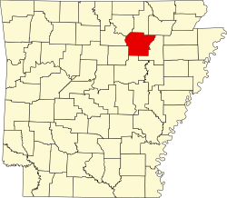
Location of Pleasant Plains in Independence County, Arkansas
Coordinates: 35°33′16″N91°37′38″W / 35.55444°N 91.62722°W / 35.55444; -91.62722
Country United States
State Arkansas
County Independence
Area
[1]
  Total1.01 sq mi (2.61 km2)
  Land1.01 sq mi (2.61 km2)
  Water0.00 sq mi (0.00 km2)
Elevation
[2]
597 ft (182 m)
Population
 (2020)
  Total352
  Density349.90/sq mi (135.11/km2)
Time zone UTC-6 (Central (CST))
  Summer (DST) UTC-5 (CDT)
ZIP code
72568
Area code 501
FIPS code 05-56270
GNIS feature ID2407136 [2]

Pleasant Plains is a town in Independence County, Arkansas, United States. The population was 349 at the 2010 census, [3] up from 267 in 2000.

Contents

History

The historic Southwest Trail, a path used by most travelers entering Arkansas early in the 1800s, entered Pleasant Plains on today's U.S. Highway 167 from Southside. From Pleasant Plains the Southwest Trail headed to Sunnydale via Arkansas Highway 157, en route to Center Hill and Floyd. By the 1830s more than 80 percent of the Arkansas territory's population had entered through the Southwest Trail. The route, at the time the main route to Texas, is also known as the Old Military Road. [4]

Geography

According to the United States Census Bureau, the town has a total area of 0.93 square miles (2.4 km2), all land. [3]

Demographics

Historical population
CensusPop.Note
1910 151
1920 116−23.2%
1930 13516.4%
1940 15615.6%
1950 153−1.9%
1960 112−26.8%
1970 16244.6%
1980 26764.8%
1990 256−4.1%
2000 2674.3%
2010 34930.7%
2020 3520.9%
U.S. Decennial Census [5]

As of the census [6] of 2000, there were 267 people, 106 households, and 78 families residing in the town. The population density was 121.3/km2 (314.5/mi2). There were 120 housing units at an average density of 54.5/km2 (141.3/mi2). The racial makeup of the town was 94.76% White, 1.50% Native American, 2.25% from other races, and 1.50% from two or more races. 4.87% of the population were Hispanic or Latino of any race.

There were 106 households, out of which 34.9% had children under the age of 18 living with them, 56.6% were married couples living together, 13.2% had a female householder with no husband present, and 26.4% were non-families. 25.5% of all households were made up of individuals, and 13.2% had someone living alone who was 65 years of age or older. The average household size was 2.52 and the average family size was 3.03.

In the town, the population was spread out, with 26.2% under the age of 18, 7.5% from 18 to 24, 31.8% from 25 to 44, 21.0% from 45 to 64, and 13.5% who were 65 years of age or older. The median age was 34 years. For every 100 females, there were 103.8 males. For every 100 females age 18 and over, there were 97.0 males.

The median income for a household in the town was $22,188, and the median income for a family was $35,000. Males had a median income of $22,344 versus $17,250 for females. The per capita income for the town was $11,129. About 11.4% of families and 16.0% of the population were below the poverty line, including 13.6% of those under the age of eighteen and 30.4% of those 65 or over.

Education

Since the 1985–86 school year, public education for elementary and secondary students has been provided by the Midland School District, which includes Midland Elementary School and Midland High School, all based in this community. Midland formed as a result of consolidation of the former Pleasant Plains and Floral school districts. The consolidation of the Pleasant Plains School District and the Floral School District was effective on July 1, 1985. [7]

Transportation

Highways

Related Research Articles

<span class="mw-page-title-main">Big Flat, Arkansas</span> Town in Arkansas, United States

Big Flat is a town in Baxter and Searcy counties in the U.S. state of Arkansas. The population was 88 at the 2020 census.

<span class="mw-page-title-main">Knobel, Arkansas</span> City in Arkansas, United States

Knobel (/ˈnoʊbəl/) is a city in Clay County, Arkansas, United States. The population was 147 at the 2020 census.

<span class="mw-page-title-main">Caraway, Arkansas</span> City in Arkansas, United States

Caraway is a city in Craighead County, Arkansas, United States. The population was 1,279 at the 2010 census. It is included in the Jonesboro, Arkansas Metropolitan Statistical Area.

<span class="mw-page-title-main">Enola, Arkansas</span> Town in Arkansas, United States

Enola is a town in Faulkner County, Arkansas, United States. It is part of the Central Arkansas region. The population was 318 at the 2020 census.

<span class="mw-page-title-main">Mount Vernon, Arkansas</span> City in Arkansas, United States

Mount Vernon is a town in Faulkner County, Arkansas, United States. The population was 145 at the 2010 census. It is part of the Central Arkansas region.

<span class="mw-page-title-main">Oil Trough, Arkansas</span> Town in Arkansas, United States

Oil Trough is a town in Independence County, Arkansas, United States. The population was 260 at the 2010 census. The town is believed to have acquired its name in the early 19th century from a trough used to render bear fat, which was sold to customers in New Orleans.

<span class="mw-page-title-main">Sulphur Rock, Arkansas</span> Town in Arkansas, United States

Sulphur Rock is a town in Independence County, Arkansas, United States. The population was 456 at the 2010 census.

<span class="mw-page-title-main">Mount Pleasant, Arkansas</span> Town in Arkansas, United States

Mount Pleasant is a town in Izard County, Arkansas, United States. As of the 2020 census, the town population was 353.

<span class="mw-page-title-main">Alicia, Arkansas</span> Town in Arkansas, United States

Alicia is a town in Lawrence County, Arkansas, United States. The population was 124 at the 2010 census.

<span class="mw-page-title-main">Lynn, Arkansas</span> Town in Arkansas, United States

Lynn is a town in Lawrence County, Arkansas, United States. The population was 288 at the 2010 census.

<span class="mw-page-title-main">Garland, Arkansas</span> Town in Arkansas, United States

Garland, also known as Garland City, is a town in Miller County, Arkansas, United States. It is part of the Texarkana, Texas - Texarkana, Arkansas Metropolitan Statistical Area. The population was 195 at the 2020 census, down from 242 in 2010.

<span class="mw-page-title-main">Dell, Arkansas</span> Town in Arkansas, United States

Dell is a town in Mississippi County, Arkansas, United States. The population was 194 at the 2020 census.

<span class="mw-page-title-main">Etowah, Arkansas</span> Town in Arkansas, United States

Etowah is a town in Mississippi County, Arkansas, United States. The population was 254 at the 2020 census, down from 351 in 2010.

<span class="mw-page-title-main">Bodcaw, Arkansas</span> Town in Arkansas, United States

Bodcaw is a town in Nevada County, Arkansas, United States. The population was 121 at the 2020 census. It is part of the Hope Micropolitan Statistical Area.

<span class="mw-page-title-main">Cale, Arkansas</span> Town in Arkansas, United States

Cale is a town in Nevada County, Arkansas, United States. The population was 75 at the 2000 census. It is part of the Hope Micropolitan Statistical Area.

<span class="mw-page-title-main">Willisville, Arkansas</span> Town in Arkansas, United States

Willisville is a town in Nevada County, Arkansas, United States. The population was 148 at the 2020 census. It is part of the Hope Micropolitan Statistical Area.

<span class="mw-page-title-main">Western Grove, Arkansas</span> Town in Arkansas, United States

Western Grove is a town in northeastern Newton County, Arkansas, United States. The population was 384 at the 2010 census. It is part of the Harrison Micropolitan Statistical Area.

<span class="mw-page-title-main">DeValls Bluff, Arkansas</span> City in Arkansas, United States

DeValls Bluff is a city in and the county seat of the southern district of Prairie County, Arkansas, United States. The population was 619 at the 2010 census.

<span class="mw-page-title-main">Reyno, Arkansas</span> City in Arkansas, United States

Reyno is a city in Randolph County, Arkansas, United States. The population was 456 at the 2010 census.

<span class="mw-page-title-main">Midland, Arkansas</span> Town in Sebastian County, Arkansas, United States

Midland is a town in Sebastian County, Arkansas, United States. It is part of the Fort Smith, Arkansas-Oklahoma Metropolitan Statistical Area. The population was 325 at the 2010 census.

References

  1. "2020 U.S. Gazetteer Files". United States Census Bureau. Retrieved October 29, 2021.
  2. 1 2 U.S. Geological Survey Geographic Names Information System: Pleasant Plains, Arkansas
  3. 1 2 "Geographic Identifiers: 2010 Census Summary File 1 (G001): Pleasant Plains town, Arkansas". American Factfinder. U.S. Census Bureau. Archived from the original on February 13, 2020. Retrieved March 23, 2018.
  4. "Southwest Trail". Arkansas Heritage Trail. Arkansas Department of Parks and Tourism. Retrieved January 25, 2016.
  5. "Census of Population and Housing". Census.gov. Retrieved June 4, 2015.
  6. "U.S. Census website". United States Census Bureau . Retrieved January 31, 2008.
  7. "ConsolidationAnnex_from_1983.xls Archived 2015-09-12 at the Wayback Machine ." Arkansas Department of Education. Retrieved on October 13, 2017.