
White County is a county located in the U.S. state of Arkansas. As of the 2020 census, the population was 76,822. The county seat is Searcy. White County is Arkansas's 31st county, formed on October 23, 1835, from portions of Independence, Jackson, and Pulaski counties and named for Hugh Lawson White, a Whig candidate for President of the United States. It is an alcohol prohibition or dry county, though a few private establishments can serve alcohol.
Pleasant Plains is a town in Independence County, Arkansas, United States. The population was 349 at the 2010 census, up from 267 in 2000.

Beebe is a city in White County, Arkansas, United States. The population was 7,315 at the 2010 U.S. Census, making it the second most populous in the county. The city is home to Arkansas State University-Beebe. ASU-Beebe also has branch campuses in Heber Springs and Searcy and at Little Rock Air Force Base.
Evans is an unincorporated community and census-designated place (CDP) in Columbia County, Georgia, United States. It is a suburb of Augusta and is part of the Augusta metropolitan area. The population was 29,011 at the 2010 census, up from 17,727 at the 2000 census.

Chaparral is an unincorporated community and census-designated place (CDP) in Doña Ana and Otero counties, New Mexico. The population was 14,631 at the 2010 census. Chaparral is primarily a bedroom community for the neighboring city of El Paso, Texas, and the neighboring military installations of White Sands Missile Range and Fort Bliss. It is officially part of the Las Cruces Metropolitan Statistical Area.

Fort Davis is an unincorporated community and census-designated place (CDP) in Jeff Davis County, Texas, United States. The population was 1,201 at the 2010 census, up from 1,050 at the 2000 census. It is the county seat of Jeff Davis County.

The Southwest Trail was a 19th-century pioneer route that was the primary passageway for American settlers bound for Texas.
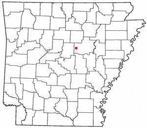
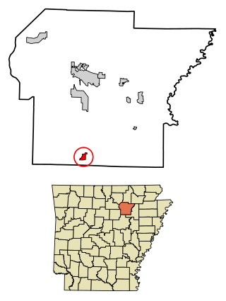
Romance is an unincorporated community in west-central White County, Arkansas, United States. The community is located approximately halfway between the town of Rose Bud to the north, and the unincorporated community of El Paso to the south. Alternately, the community is about 16 miles (26 km) northwest of Beebe, and less than 5 miles (8 km) east of Mount Vernon.

El Paso is an unincorporated community and census-designated place (CDP) in southwestern White County, Arkansas, United States. It was first listed as a CDP in the 2020 census with a population of 267. Its name is Spanish for "the pass", referring to a small gap in the hills on the community's northern edge. Once known as Peach Orchard Gap in its early settlement, the origin of El Paso's Spanish name is unknown.
Magnet Cove is a census-designated place (CDP) and former town in Hot Spring County, Arkansas, United States. It is located in the Ouachita Mountains southeast of Hot Springs, on Arkansas Highway 51 north of U.S. Highway 270. As of the 2020 census, the town of Magnet Cove had a population of 692.

Canehill, also known as Cane Hill and Boonsboro, is an unincorporated community and census-designated place (CDP) in Washington County, Arkansas, United States. It was first listed as a CDP in the 2020 census with a population of 74.

New Edinburg is an unincorporated census-designated place in Cleveland County, Arkansas, United States. Per the 2020 census, the population was 134.

Kingston is an unincorporated community and census-designated place (CDP) in northeast Madison County, Arkansas, United States. It was first listed as a CDP in the 2020 census with a population of 97.
Princeton is a small unincorporated rural village in Princeton Township, Dallas County, Arkansas, United States, located at the junction of Arkansas highways 8 and 9, 7.5 miles (12.1 km) southwest of Carthage. Princeton Cemetery, which is listed on the National Register of Historic Places, is located in the community. It was first listed as a CDP in the 2020 census with a population of 13.
Buffalo City is an unincorporated community and census-designated place (CDP) in Baxter County, Arkansas, United States. It was first listed as a CDP in the 2020 census with a population of 26.

Yarborough Landing is a census-designated place in Little River County, Arkansas, United States. Per the 2020 census, the population was 457.
Wesley is an unincorporated community and census-designated place (CDP) in western Madison County, Arkansas, United States. Wesley is located at the junction of Arkansas highways 74 and 295, 13 miles (21 km) by road west-southwest of Huntsville. Wesley has a post office with ZIP code 72773. It was first listed as a CDP in the 2020 census with a population of 161.
Lawson is an unincorporated community and census-designated place (CDP) in Union County, Arkansas, United States. Lawson was founded by Lawson Smith, who was born in 1813 and died in 1899. Lawson is located on Arkansas Highway 129, 10.5 miles (16.9 km) east of El Dorado. Lawson has a post office with ZIP code 71750. It was first listed as a CDP in the 2020 census with a population of 260.
Mount Olive is an unincorporated community and census-designated place (CDP) in Izard County, Arkansas, United States. Mount Olive is located on the White River, 11.1 miles (17.9 km) west-southwest of Melbourne.

Gibson is a census-designated place (CDP) in Pulaski County, Arkansas, United States. The population was 3,543 at the 2010 census. It is part of the Little Rock–North Little Rock–Conway Metropolitan Statistical Area.

