Pangburn, Arkansas

Last updated

Pangburn, Arkansas
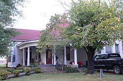
Avanell Wright House.JPG
White County Arkansas Incorporated and Unincorporated areas Pangburn Highlighted 0553240.svg
Location of Pangburn in White County, Arkansas.
Coordinates: 35°25′36″N91°50′13″W / 35.42667°N 91.83694°W / 35.42667; -91.83694
Country United States
State Arkansas
County White
Area
[1]
  Total0.55 sq mi (1.41 km2)
  Land0.55 sq mi (1.41 km2)
  Water0.00 sq mi (0.00 km2)
Elevation
348 ft (106 m)
Population
 (2020)
  Total500
  Density917.43/sq mi (354.28/km2)
Time zone UTC-6 (Central (CST))
  Summer (DST) UTC-5 (CDT)
ZIP code
72121
Area code 501
FIPS code 05-53240
GNIS feature ID53143 [2]

Pangburn is a city in White County, Arkansas, United States. [2] The population was 500 at the 2020 census.

Contents

Geography

According to the United States Census Bureau, the city has a total area of 0.6 square miles (1.6 km2), all land.

Demographics

Historical population
CensusPop.Note
1920 706
1930 634−10.2%
1940 595−6.2%
1950 66912.4%
1960 489−26.9%
1970 65433.7%
1980 6732.9%
1990 630−6.4%
2000 6543.8%
2010 601−8.1%
2020 500−16.8%
U.S. Decennial Census [3]

At the 2000 census there were 654 people in 275 households, including 188 families, in the city. The population density was 1,160.1 inhabitants per square mile (447.9/km2). There were 332 housing units at an average density of 588.9 per square mile (227.4/km2). The racial makeup of the city was 98.78% White, 0.15% Black or African American, 0.15% Native American, 0.61% from other races, and 0.31% from two or more races. 1.53% of the population were Hispanic or Latino of any race. [4] Of the 275 households 30.5% had children under the age of 18 living with them, 49.1% were married couples living together, 16.0% had a female householder with no husband present, and 31.6% were non-families. 28.4% of households were one person and 16.4% were one person aged 65 or older. The average household size was 2.38 and the average family size was 2.88.

The age distribution was 28.0% under the age of 18, 8.1% from 18 to 24, 25.1% from 25 to 44, 20.8% from 45 to 64, and 18.0% 65 or older. The median age was 36 years. For every 100 females, there were 87.4 males. For every 100 females age 18 and over, there were 84.0 males.

The median household income was $25,735 and the median family income was $31,250. Males had a median income of $26,750 versus $18,594 for females. The per capita income for the city was $15,234. About 10.1% of families and 15.9% of the population were below the poverty line, including 23.2% of those under age 18 and 16.3% of those age 65 or over.

Education

Public education is provided to elementary and secondary school students by the Pangburn School District, which includes Pangburn High School.

Related Research Articles

<span class="mw-page-title-main">Weston, Idaho</span> City in Idaho, United States

Weston is a city in Franklin County, Idaho, United States. The population was 437 at the 2010 census. It is part of the Logan, Utah-Idaho Metropolitan Statistical Area. It was first settled in 1865. The community was so named on account of its location at the west bank of the Bear River.

<span class="mw-page-title-main">Atkins, Iowa</span> City in Iowa, United States

Atkins is a city in Benton County, Iowa, United States. The population was 2,056 at the 2020 census. It is part of the Cedar Rapids Metropolitan Statistical Area.

<span class="mw-page-title-main">Webster, Iowa</span> City in Iowa, United States

Webster is a city in Keokuk County, Iowa, United States. The population was 94 at the time of the 2020 census.

<span class="mw-page-title-main">Brunsville, Iowa</span> City in Iowa, United States

Brunsville is a city in Plymouth County, Iowa, United States. The population was 129 at the 2020 census.

<span class="mw-page-title-main">Boyden, Iowa</span> City in Iowa, United States

Boyden is a city in Sioux County, Iowa, United States. The population was 701 at the 2020 census.

<span class="mw-page-title-main">Briarwood, Kentucky</span> City in Kentucky, United States

Briarwood is a home rule-class city in Jefferson County, Kentucky, United States. The population was 435 at the 2010 census, down from 554 at the 2000 census.

<span class="mw-page-title-main">Bagley, Minnesota</span> City in Minnesota, United States

Bagley is a city in Clearwater County, Minnesota, United States. The population was 1,285 at the 2020 census. It is the county seat of Clearwater County.

Fairfield Township is a township in Crow Wing County, Minnesota, United States. The population was 275 at the 2000 census.

<span class="mw-page-title-main">Cook, Minnesota</span> City in Minnesota, United States

Cook is a city in Saint Louis County, Minnesota, United States. The population was 515 at the 2010 census.

<span class="mw-page-title-main">Echo, Minnesota</span> City in Minnesota, United States

Echo is a city in Yellow Medicine County, Minnesota, United States. The population was 243 at the 2020 census.

<span class="mw-page-title-main">Pleasant Hope, Missouri</span> City in Missouri, United States

Pleasant Hope is a city in Polk County, Missouri, United States. The population was 614 at the 2010 census. It is part of the Springfield, Missouri Metropolitan Statistical Area.

<span class="mw-page-title-main">Nelson, Missouri</span> City in Missouri, United States

Nelson is a city in Saline County, Missouri, United States. The population was 152 at the 2020 census.

<span class="mw-page-title-main">Bellerive Acres, Missouri</span> City in Missouri, United States

Bellerive Acres is a northern suburban city in St. Louis County, Missouri, United States. The population was 188 at the 2010 census. In April, 2015, the residents voted to change the village of Bellerive to a fourth class city named Bellerive Acres.

<span class="mw-page-title-main">Fairfield, Nebraska</span> City in Nebraska, United States

Fairfield is a city in Clay County, Nebraska, United States. The population was 387 at the 2010 census. It is part of the Hastings, Nebraska Micropolitan Statistical Area.

<span class="mw-page-title-main">Bloomfield, Nebraska</span> City in Nebraska, United States

Bloomfield is a city in Knox County, Nebraska, United States. The population was 1,028 at the 2010 census.

<span class="mw-page-title-main">Covedale, Ohio</span> Census-designated place in Ohio, United States

Covedale is a census-designated place (CDP) in Green Township, Hamilton County, Ohio, United States. The population was 6,472 at the 2020 census. The CDP represents the part of the former village of Covedale that was not annexed by the city of Cincinnati in 1930.

<span class="mw-page-title-main">Howe Township, Perry County, Pennsylvania</span> Township in Pennsylvania, United States

Howe Township is a township in Perry County, Pennsylvania, United States. The population was 375 at the 2020 census.

<span class="mw-page-title-main">Barry Township, Pennsylvania</span> Township in Pennsylvania, United States

Barry Township is a township in Schuylkill County, Pennsylvania. Formed in 1822, it is named for American Revolutionary War Commander John Barry and was formed from parts of Norwegian and Schuylkill Townships.

<span class="mw-page-title-main">Waubay, South Dakota</span> City in South Dakota, United States

Waubay is a city in Day County, South Dakota, United States. The population was 473 at the 2020 census.

<span class="mw-page-title-main">Newburg, West Virginia</span> Town in West Virginia, United States

Newburg is a town in western Preston County, West Virginia, United States. The population was 275 at the 2020 census. It is part of the Morgantown metropolitan area.

References

  1. "2020 U.S. Gazetteer Files". United States Census Bureau. Retrieved October 29, 2021.
  2. 1 2 U.S. Geological Survey Geographic Names Information System: Pangburn
  3. "Census of Population and Housing". Census.gov. Retrieved June 4, 2015.
  4. "U.S. Census website". United States Census Bureau . Retrieved January 31, 2008.