West Point, Arkansas

Last updated

West Point, Arkansas
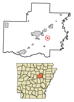
White County Arkansas Incorporated and Unincorporated areas West Point Highlighted 0574660.svg
Location of West Point in White County, Arkansas.
Coordinates: 35°12′19″N91°36′42″W / 35.20528°N 91.61167°W / 35.20528; -91.61167
Country United States
State Arkansas
County White
Area
[1]
  Total0.43 sq mi (1.11 km2)
  Land0.43 sq mi (1.11 km2)
  Water0.00 sq mi (0.00 km2)
Elevation
203 ft (62 m)
Population
 (2020)
  Total170
  Density395.35/sq mi (152.67/km2)
Time zone UTC-6 (Central (CST))
  Summer (DST) UTC-5 (CDT)
ZIP code
72178
Area code 501
FIPS code 05-74660
GNIS feature ID0058858

West Point is a town in White County, Arkansas, United States.

Contents

David Hamilton was mayor from “1972 except for two years he missed for cancer surgery," according to an article in the Searcy, Arkansas newspaper The Daily Citizen ("Mayors bring politics, leadership to ground level" by Warren Watkins, January 27, 2007). “My great-grandfather landed at West Point in 1865 from a steamboat, and homesteaded 160 acres (0.65 km2) of land by building a log house,” Hamilton said.

Ron Faith has served as mayor since Hamilton's death in 2013.

The same article gives the West Point population as 208.

Incorporated in 1858, West Point marked its sesquicentennial in 2008. According to local legend, cited by the mayor, the town was in the running with Little Rock to be the site of the state capitol.

Geography

West Point is located along the Little Red River at 35°12′19″N91°36′42″W / 35.20528°N 91.61167°W / 35.20528; -91.61167 (35.205295, -91.611774). [2]

According to the United States Census Bureau, the town has a total area of 1.0 km2 (0.4 mi2), all land.

Demographics

Historical population
CensusPop.Note
1880 123
1900 111
1910 1164.5%
1920 16239.7%
1930 1662.5%
1940 145−12.7%
1950 115−20.7%
1960 97−15.7%
1970 18489.7%
1980 22622.8%
1990 146−35.4%
2000 16412.3%
2010 18512.8%
2020 170−8.1%
U.S. Decennial Census [3]

As of the census [4] of 2000, there were 164 people, 65 households, and 44 families residing in the town. The population density was 158.3/km2 (411.9/mi2). There were 68 housing units at an average density of 65.6/km2 (170.8/mi2). The racial makeup of the town was 91.46% White, 3.66% Black or African American, 0.61% Pacific Islander, and 4.27% from two or more races. 6.10% of the population were Hispanic or Latino of any race.

There were 65 households, out of which 32.3% had children under the age of 18 living with them, 52.3% were married couples living together, 15.4% had a female householder with no husband present, and 32.3% were non-families. 26.2% of all households were made up of individuals, and 7.7% had someone living alone who was 65 years of age or older. The average household size was 2.52 and the average family size was 3.14.

In the town, the population was spread out, with 24.4% under the age of 18, 15.2% from 18 to 24, 29.9% from 25 to 44, 16.5% from 45 to 64, and 14.0% who were 65 years of age or older. The median age was 31 years. For every 100 females, there were 95.2 males. For every 100 females age 18 and over, there were 96.8 males.

The median income for a household in the town was $23,125, and the median income for a family was $24,375. Males had a median income of $20,208 versus $23,333 for females. The per capita income for the town was $11,657. About 26.1% of families and 26.1% of the population were below the poverty line, including 42.1% of those under the age of 18 and 33.3% of those 65 or over.

Related Research Articles

<span class="mw-page-title-main">Chester, Arkansas</span> Town in Arkansas, United States

Chester is a town in Crawford County, Arkansas, United States. It is part of the Fort Smith, Arkansas-Oklahoma Metropolitan Statistical Area. As of the 2020 Census the population was 144.

<span class="mw-page-title-main">Mount Pleasant, Arkansas</span> Town in Arkansas, United States

Mount Pleasant is a town in Izard County, Arkansas, United States. As of the 2020 census, the town population was 353.

<span class="mw-page-title-main">Beedeville, Arkansas</span> Town in Arkansas, United States

Beedeville is a town in Jackson County, Arkansas, United States. The population was 107 at the 2010 census.

<span class="mw-page-title-main">Alicia, Arkansas</span> Town in Arkansas, United States

Alicia is a town in Lawrence County, Arkansas, United States. The population was 124 at the 2010 census.

<span class="mw-page-title-main">Minturn, Arkansas</span> Town in Arkansas, United States

Minturn is a town in Lawrence County, Arkansas, United States. The population was 109 at the 2010 census.

<span class="mw-page-title-main">Strawberry, Arkansas</span> Town in Arkansas, United States

Strawberry is a town in Lawrence County, Arkansas, United States. The population was 302 at the 2010 census.

<span class="mw-page-title-main">Allport, Arkansas</span> Town in Arkansas, United States

Allport is a town in Lonoke County, Arkansas, United States. Although a black enclave in the largely-white Lonoke County since the 1870s, the town did not incorporate until 1967 in order to receive funding for municipal services. Located within Central Arkansas along Highway 165, the community's economy is strongly tied to agriculture. The population was 115 at the 2010 Census.

<span class="mw-page-title-main">Widener, Arkansas</span> Town in Arkansas, United States

Widener is a town in St. Francis County, Arkansas, United States. The population was 212 at the 2020 census, a decline from 273 in 2010.

<span class="mw-page-title-main">Garner, Arkansas</span> Town in Arkansas, United States

Garner is a town in White County, Arkansas, United States. Brandy Goodwin is the current mayor. The population was 284 at the 2000 census.

<span class="mw-page-title-main">Griffithville, Arkansas</span> Town in Arkansas, United States

Griffithville is a town in White County, Arkansas, United States. Windle Porter is the current mayor. The population was 262 at the 2000 census.

<span class="mw-page-title-main">Letona, Arkansas</span> Town in Arkansas, United States

Letona is a town in White County, Arkansas, United States. Sherrel Bennett is the current mayor. The population was 201 at the 2000 census.

<span class="mw-page-title-main">Russell, Arkansas</span> Town in Arkansas, United States

Russell is a town in White County, Arkansas, United States. Tracy Lee Klotz is the current mayor. The population was 228 at the 2000 census.

<span class="mw-page-title-main">Hunter, Arkansas</span> Town in Arkansas, United States

Hunter is a town in southeast Woodruff County, Arkansas, United States. The population was 152 at the 2000 census.

<span class="mw-page-title-main">Patterson, Arkansas</span> City in Arkansas, United States

Patterson is a city in Woodruff County, Arkansas, United States. The population was 452 at the 2010 census.

<span class="mw-page-title-main">Andover, Florida</span> Neighborhood of Miami Gardens in Miami-Dade, Florida, United States

Andover is a neighborhood in Miami Gardens, Florida. It was formerly a census-designated place. The population was 8,489 at the 2000 census. Transmitters for several Miami television stations are located in Andover.

<span class="mw-page-title-main">Duxbury (CDP), Massachusetts</span> Census-designated place in Massachusetts, United States

Duxbury is a census-designated place (CDP) in the town of Duxbury in Plymouth County, Massachusetts, United States. The population was 1,802 at the 2010 census.

<span class="mw-page-title-main">Milford (CDP), Massachusetts</span> CDP in Massachusetts, United States

Milford is a census-designated place (CDP) in the town of Milford in Worcester County, Massachusetts, United States. The population was 25,055 at the 2010 census.

<span class="mw-page-title-main">North Brookfield (CDP), Massachusetts</span> CDP in Massachusetts, United States

North Brookfield is a census-designated place (CDP) in the town of North Brookfield in Worcester County, Massachusetts, United States. The population was 2,265 at the 2010 census.

<span class="mw-page-title-main">West Brookfield (CDP), Massachusetts</span> Census-designated place in Massachusetts, United States

West Brookfield is a census-designated place (CDP) in the town of West Brookfield in Worcester County, Massachusetts, United States. The population was 1,413 at the 2010 census.

Seymour is a census-designated place (CDP) in Eau Claire County, Wisconsin, United States. The population was 1,418 at the 2010 census. It is located within the town of Seymour and is part of the Eau Claire urban area.

References

  1. "2020 U.S. Gazetteer Files". United States Census Bureau. Retrieved October 29, 2021.
  2. "US Gazetteer files: 2010, 2000, and 1990". United States Census Bureau. February 12, 2011. Retrieved April 23, 2011.
  3. "Census of Population and Housing". Census.gov. Retrieved June 4, 2015.
  4. "U.S. Census website". United States Census Bureau . Retrieved January 31, 2008.