Related Research Articles

Washington State Park is a public recreation area covering 2,147 acres (869 ha) in Washington County in the central eastern part of the state of Missouri. It is located on Highway 21 about 14 miles (23 km) northeast of Potosi or 7 miles (11 km) southwest of De Soto on the eastern edge of the Ozarks. The state park is noted for its Native American rock carvings and for its finely crafted stonework from the 1930s.

Millstone Bluff is a natural bluff in Pope County, Illinois, United States, located near the community of Glendale. Listed on the National Register of Historic Places because of its archaeological significance, Millstone Bluff is one of three National Register sites in Pope County, along with the Golconda Historic District and part of the Kincaid Mounds State Historic Site.
Legend Rock Petroglyph Site is located in Hot Springs County, Wyoming, 20 miles northwest of Hot Springs State Park. Legend Rock is a petroglyph site which features hundreds of individual petroglyphs spread across the face of the rock. Although a handful of the rock's etchings have variously been eroded and defaced, a wide majority have been preserved for public viewing. The nearly 300 individual petroglyphs feature some of the oldest and best examples of Dinwoody rock art in the world. The origins of the petroglyphs are still subject to debate. The site was listed on the National Register of Historic Places on July 5, 1973 and it is preserved by the state of Wyoming as a state historic site.
Salado is an unincorporated area and census-designated place (CDP) in Independence County, Arkansas, United States. It was first listed as a CDP in the 2020 census with a population of 472.

This is a list of the National Register of Historic Places listings in Independence County, Arkansas.
Mantle's Cave is a cliff alcove in Dinosaur National Monument in Moffat County, Colorado. Located in the Castle Park region of the park, it is the largest rock shelter in the area. It was discovered before 1921 by local ranchers, Mr. and Mrs. Charles Mantle. Mrs. Mantle is reported to have done some excavation of the site, followed up by the Penrose-Taylor expedition of 1933 from Colorado College and the Fountain Valley School, which designated the site "Cave One." The site is a significant resource for the Fremont culture and is among the best resources in northwestern Colorado. Excavations in the 1930s and 1940s yielded significant material on the Fremont people and their relationship to the later Ancestral Puebloans.

Judaculla Rock is a curvilinear-shaped outcrop of soapstone known for its ancient carvings and petroglyphs. The archaeological site is located on a 0.85-acre rectangular-shaped property, now owned by Jackson County. It is approximately 60 meters east of Caney Fork Creek, a major branch of the northwestward-trending Tuckasegee River in the mountains of Western North Carolina.

The Bellows Falls Petroglyph Site is an archaeological site containing panels of precontact Native American petroglyphs in Bellows Falls, Vermont. Located near the Vilas Bridge on bedrock west of and above the Connecticut River, adjacent to Great Falls, they depict a rarely-seen assemblage of anthropomorphic figures that is believed to be unique in New England, and uncommon even in surrounding geographic areas. The site was listed on the National Register of Historic Places in 1990.

The Goff Farm Stone Bridge is a historic bridge in eastern Fayetteville, Arkansas. It carries Goff Farm Road across an unnamed creek just north of Stonebridge Meadows Golf Club. The bridge is a single-span stone arch with a span of 20 feet (6.1 m) and a total bridge length of 150 feet (46 m). The bridge's builder is unknown, and its design suggests it was built circa 1860, when the road it carries was a major east–west thoroughfare connecting Fayetteville and Huntsville. It is believed to be the oldest masonry bridge in the state, and is one of the state's small number of surviving 19th-century stone bridges.
The High Rock Petroglyph Shelter is a prehistoric rock art site in Crawford County, Arkansas. Set in a high and rugged location in the western Ozark Mountains with views of the surrounding countryside, the site includes a sheltered petroglyph representation of a human figure. The setting is one that is somewhat typical for other examples of rock art in the region.

The Ruddell Mill Site is a historic early industrial site near Batesville, Arkansas. It is the site of a mill established by John Ruddell, one of the early settlers of Independence County who established several mills on the creeks and streams that traversed the area north of the White River. The mill was operated by the Ruddells until 1917, and the main building was destroyed by fire in the 1930s. Surviving elements include a stone foundation, mill dam, and a low-water bridge built over the dam in the early 20th century.
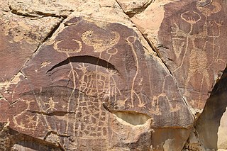
The Wyatt Petroglyphs are rock art located in Independence County, Arkansas, in the general vicinity of the city of Desha. The petroglyphs are of a type commonly found in eastern Missouri and southern Illinois, and are believed to date to about 1500 CE. Depictions include a thunderbird, bird tracks, arrows, human figures, and crescents and sun rays, all typical of other known regional petroglyph sites. Their relationship to area Native American archaeological sites is not well understood.
The Edgemont Shelter, also designated by the Smithsonian trinomial 3VB6, is a prehistoric rock art site in Van Buren County, Arkansas. Located on a bluff overlooking Greers Ferry Lake, it consists of a panel extensively painted with petroglyphs. The site has been dated to about 1500.

The Crow Mountain Petroglyph is a small petroglyph rock art panel in Pope County, Arkansas. The panel includes a sun motif and an arrow, both of which have been pecked into the rock. Although its provenance and age are unknown, it is similar in style to other examples of rock art in the United States. The arrow was observed on December 21, 1978 to point at the location of that day's sunset, so its use as a prehistoric solstice marker cannot be ruled out.
The King's Canyon Petroglyphs are a prehistoric rock art site near Clarksville, Arkansas. The site includes a panel petroglyphs, which include depictions of a sunburst motif and what look like turkey tracks. The latter is a particularly uncommon subject for rock art in this area.
Fertile is an unincorporated community in Washington County, in the U.S. state of Missouri.

The Newspaper Rock Petroglyphs Archeological District is part of the Petrified Forest National Park, and contains in excess of 650 petroglyphs, believed to have been created 1000–1500 CE. This Apache County site near Adamana, Arizona was listed on the National Register of Historic Places July 12, 1976.

The Castle Gardens Petroglyph Site is a 6-mile (9.7 km) by 1-mile (1.6 km) region of vertical cliff faces in Fremont County, Wyoming, United States, with extensive petroglyph images incised in the rock faces. The glyphs include images of water turtles and circular shields, as well as human and animal figures. The figures with circular shields are particular to the area, and are known as Castle Gardens Shield style images. A consensus of researchers is that the figures were carved by Athabaskans related to the Navajo and Apache, some time between 1000 AD and 1250 AD. The site is being developed by the Bureau of Land Management, and may be visited.

The Tolar Petroglyph Site is an archeological site in Sweetwater County, Wyoming. The site includes a sandstone rock formation with 32 panels of petroglyphs running for 150 feet (46 m) along the rock face. Many of the illustrations are of horse-mounted people of the Plains Indians in historical times. Other motifs include the turtle motif, spirit bear and shield-carrying warriors.
References
- 1 2 "National Register Information System". National Register of Historic Places . National Park Service. July 9, 2010.
- ↑ "Summary description of Goff Petroglyph Site". Arkansas Preservation. Retrieved July 16, 2015.
| Topics | |
|---|---|
| Lists by state |
|
| Lists by insular areas | |
| Lists by associated state | |
| Other areas | |
| Related | |
| | This article about a property in Independence County, Arkansas on the National Register of Historic Places is a stub. You can help Wikipedia by expanding it. |