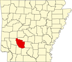
Caddo Valley, Arkansas

Last updated

Caddo Valley, Arkansas
Highway 67 and Highway 7 in Caddo Valley, AR.jpg
Clark County Arkansas Incorporated and Unincorporated areas Caddo Valley Highlighted 0510360.svg
Location of Caddo Valley in Clark County, Arkansas.
Coordinates: 34°11′49″N93°02′56″W / 34.19694°N 93.04889°W / 34.19694; -93.04889
Country United States
State Arkansas
County Clark
Area
[1]
  Total3.11 sq mi (8.06 km2)
  Land3.10 sq mi (8.02 km2)
  Water0.01 sq mi (0.03 km2)
Elevation
[2]
279 ft (85 m)
Population
 (2020)
  Total595
  Density192.06/sq mi (74.15/km2)
Time zone UTC-6 (Central (CST))
  Summer (DST) UTC-5 (CDT)
ZIP code
71923
Area code 870
FIPS code 05-10360
GNIS feature ID2405355 [2]
Website www.thecityofcaddovalley.com

Caddo Valley is a town in Clark County, Arkansas, United States. The population was 635 at the 2010 census. [3]

Contents

Geography

Caddo Valley is located in northeastern Clark County on the north side of the Caddo River 2 miles (3 km) west of its mouth at the Ouachita River. The town is 4 miles (6 km) north of Arkadelphia, the county seat.

According to the United States Census Bureau, Caddo Valley has a total area of 2.9 square miles (7.6 km2), of which 0.012 square miles (0.03 km2), or 0.45%, is water. [3]

Demographics

Historical population
CensusPop.Note
1980 388
1990 3890.3%
2000 56344.7%
2010 63512.8%
2020 595−6.3%
U.S. Decennial Census [4]

As of the census [5] of 2000, there were 563 people, 242 households, and 150 families residing in the town. The population density was 73.7/km2 (190.6/mi2). There were 274 housing units at an average density of 35.9/km2 (92.8/mi2). The racial makeup of the town was 86.86% White, 9.59% Black or African American, 0.36% Native American, 1.07% from other races, and 2.13% from two or more races. 1.07% of the population were Hispanic or Latino.

There were 242 households, out of which 31.8% had children under the age of 18 living with them, 48.3% were married couples living together, 9.9% had a female householder with no husband present, and 38.0% were non-families. 30.6% of all households were made up of individuals, and 7.9% had someone living alone who was 65 years of age or older. The average household size was 2.33 and the average family size was 2.93.

In the town, the population was spread out, with 25.6% under the age of 18, 16.7% from 18 to 24, 27.9% from 25 to 44, 20.2% from 45 to 64, and 9.6% who were 65 years of age or older. The median age was 28 years. For every 100 females, there were 98.9 males. For every 100 females age 18 and over, there were 89.6 males.

The median income for a household in the town was $28,750, and the median income for a family was $35,417. Males had a median income of $25,000 compared to $18,875 for females. The per capita income for the town was $13,083. About 10.2% of families and 16.0% of the population were below the poverty line, including 20.4% of those under age 18 and 23.4% of those age 65 or over.

Highways

Caddo Valley, incorporated in 1974, is a major highway intersection. The town is 4 miles (6 km) north of Arkadelphia by U.S. Route 67, which also leads northeast 21 miles (34 km) to Malvern. Caddo Valley is served by Exit 78 of Interstate 30, which leads 64 miles (103 km) northeast to Little Rock and 79 miles (127 km) southwest to Texarkana. Arkansas Highway 7 leads north from Caddo Valley 30 miles (48 km) to Hot Springs and Hot Springs National Park.

DeGray Dam is 3 miles (5 km) north, and DeGray Lake Resort State Park is 5 miles (8 km) north. The town sometimes is billed as "The Gateway to DeGray Lake".

Education

It is within the Arkadelphia School District, [6] which operates Arkadelphia High School.

Government

Caddo Valley passed a 1-percent sales tax in 1981 to fund its fire and police departments. It is governed by a mayor and town council. [7]

Related Research Articles

<span class="mw-page-title-main">Clark County, Arkansas</span> County in Arkansas, United States

Clark County is a county located in the south-central part of the U.S. state of Arkansas. As of the 2020 census, the population was 21,446. The county seat is Arkadelphia. The Arkadelphia, AR Micropolitan Statistical Area includes all of Clark County.

<span class="mw-page-title-main">Amity, Arkansas</span> City in Arkansas, United States

Amity is a city in Clark County, Arkansas, United States. The population was 723 at the 2010 census. The city began on the Caddo River in the mid-19th century when William F. Browning and others, including A.B. Clingman, at various times moved to the area.

<span class="mw-page-title-main">Arkadelphia, Arkansas</span> City in Arkansas, United States

Arkadelphia is a city in Clark County, Arkansas, United States. As of the 2020 census, the population was 10,380. The city is the county seat of Clark County. It is situated at the foothills of the Ouachita Mountains. Two universities, Henderson State University and Ouachita Baptist University, are located here. Arkadelphia was incorporated in 1857.

<span class="mw-page-title-main">Gum Springs, Arkansas</span> Town in Arkansas, United States

Gum Springs is a town in Clark County, Arkansas, United States. The population was 120 at the 2010 census, down from 194 in 2000.

<span class="mw-page-title-main">Okolona, Arkansas</span> Town in Arkansas, United States

Okolona is a town near the western edge of Clark County, Arkansas, United States. The population was 147 at the 2010 census.

<span class="mw-page-title-main">Whelen Springs, Arkansas</span> Town in Arkansas, United States

Whelen Springs is a town in Clark County, Arkansas, United States. The population was 92 at the 2010 census. From 1930 through 1939 the town thrived, being a main hub of operations for the then powerful Ozan Lumber Company.

<span class="mw-page-title-main">Dyer, Arkansas</span> City in Arkansas, United States

Dyer is a city in Crawford County, Arkansas, United States. It is part of the Fort Smith, Arkansas-Oklahoma Metropolitan Statistical Area. The population was 876 at the 2010 census.

<span class="mw-page-title-main">Tull, Arkansas</span> Town in Arkansas, United States

Tull is a town in Grant County, Arkansas, United States. The population was 448 at the 2010 census, up from 358 in 2000. It is part of the Central Arkansas region.

<span class="mw-page-title-main">Donaldson, Arkansas</span> Town in Arkansas, United States

Donaldson is a town in Hot Spring County, Arkansas, United States. The population was 301 at the 2010 census.

<span class="mw-page-title-main">Magness, Arkansas</span> Town in Arkansas, United States

Magness is a town in Independence County, Arkansas, United States. The population was 202 at the 2010 census. The mayor is Jerrit Pectol.

<span class="mw-page-title-main">Lynn, Arkansas</span> Town in Arkansas, United States

Lynn is a town in Lawrence County, Arkansas, United States. The population was 288 at the 2010 census.

<span class="mw-page-title-main">Strawberry, Arkansas</span> Town in Arkansas, United States

Strawberry is a town in Lawrence County, Arkansas, United States. The population was 302 at the 2010 census.

<span class="mw-page-title-main">Blue Mountain, Arkansas</span> Town in Arkansas

Blue Mountain is a town in Logan County, Arkansas, United States. The population was 124 at the 2010 census.

<span class="mw-page-title-main">Morrison Bluff, Arkansas</span> Town in Arkansas, United States

Morrison Bluff is a town in Logan County, Arkansas, United States. The population was 64 at the 2010 census and an estimated 81 in 2017.

<span class="mw-page-title-main">Coy, Arkansas</span> Town in Arkansas, United States

Coy is a town in southern Lonoke County, Arkansas, United States. The population was 96 at the 2010 census, making it the smallest incorporated community within the Little Rock–North Little Rock–Conway Metropolitan Statistical Area, as well as one of the smallest in the state.

<span class="mw-page-title-main">Birdsong, Arkansas</span> Town in Arkansas, United States

Birdsong is a town in Mississippi County, Arkansas, United States. The population was 32 at the 2020 census, down from 41 in 2010.

<span class="mw-page-title-main">Black Springs, Arkansas</span> Town in Arkansas, United States

Black Springs is a town in Montgomery County, Arkansas, United States. The population was 96 at the 2020 census.

<span class="mw-page-title-main">Norman, Arkansas</span> Town in Arkansas, United States

Norman is a town in Montgomery County, Arkansas, United States. It was known as Womble until 1925. The population was 303 at the 2020 census, down from 378 in 2010.

<span class="mw-page-title-main">Glenwood, Arkansas</span> City in Arkansas, United States

Glenwood is a city in Pike and Montgomery counties in Arkansas, United States. As of the 2020 census, its population was 2,068. The community is located along the Caddo River in the Ouachita Mountains.

<span class="mw-page-title-main">Binger, Oklahoma</span> Town in Oklahoma, United States

Binger is a town in Caddo County, Oklahoma, United States. The population was 672 at the 2010 census. It is the headquarters of the Caddo Nation of Oklahoma, who were settled in the area during the 1870s.

References

  1. "2020 U.S. Gazetteer Files". United States Census Bureau. Retrieved October 29, 2021.
  2. 1 2 U.S. Geological Survey Geographic Names Information System: Caddo Valley, Arkansas
  3. 1 2 "Geographic Identifiers: 2010 Demographic Profile Data (G001): Caddo Valley town, Arkansas". U.S. Census Bureau, American Factfinder. Archived from the original on February 12, 2020. Retrieved June 16, 2014.
  4. "Census of Population and Housing". Census.gov. Retrieved June 4, 2015.
  5. "U.S. Census website". United States Census Bureau . Retrieved January 31, 2008.
  6. "2020 CENSUS - SCHOOL DISTRICT REFERENCE MAP: Clark County, AR" (PDF). U.S. Census Bureau . Retrieved March 12, 2023.
  7. Arkansas Department of Parks and Tourism, Tourism Division, 1 Capitol Mall, Little Rock, Ark. 72201