Blevins, Arkansas

Last updated

Blevins, Arkansas
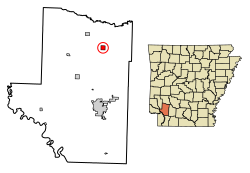
Hempstead County Arkansas Incorporated and Unincorporated areas Blevins Highlighted 0507030.svg
Location of Blevins in Hempstead County, Arkansas.
Coordinates: 33°52′16″N93°34′36″W / 33.87111°N 93.57667°W / 33.87111; -93.57667
Country United States
State Arkansas
County Hempstead
Area
[1]
  Total0.99 sq mi (2.58 km2)
  Land0.99 sq mi (2.58 km2)
  Water0.00 sq mi (0.00 km2)
Elevation
[2]
420 ft (128 m)
Population
 (2020)
  Total288
  Density289.74/sq mi (111.84/km2)
Time zone UTC-6 (Central (CST))
  Summer (DST) UTC-5 (CDT)
ZIP code
71825
Area code 870
FIPS code 05-07030
GNIS feature ID0046718 [2]

Blevins is a city in Hempstead County, Arkansas, United States. The population was 315 at the 2010 census, [3] down from 365 in 2000. It is part of the Hope Micropolitan Statistical Area.

Contents

Geography

Blevins is located in northeastern Hempstead County at 33°52′16″N93°34′36″W / 33.87111°N 93.57667°W / 33.87111; -93.57667 (33.871218, -93.576666). [4] U.S. Route 371 passes through the city as Center Street, leading southeast 15 miles (24 km) to Prescott and northwest 19 miles (31 km) to Nashville. Arkansas Highway 29 is Main Street in Blevins, crossing US 371 in the center of town and leading northeast 18 miles (29 km) to Antoine and south 15 miles (24 km) to Hope, the Hempstead County seat.

According to the United States Census Bureau, the city of Blevins has a total area of 1.0 square mile (2.6 km2), all land. [3]

Demographics

Historical population
CensusPop.Note
1930 291
1940 33113.7%
1950 271−18.1%
1960 198−26.9%
1970 26533.8%
1980 31418.5%
1990 253−19.4%
2000 36544.3%
2010 315−13.7%
2020 288−8.6%
U.S. Decennial Census [5]
2014 Estimate [6]

At the 2000 census, [7] there were 365 people, 131 households and 102 families residing in the city. The population density was 365.8 inhabitants per square mile (141.2/km2). There were 152 housing units at an average density of 152.4 per square mile (58.8/km2). The racial makeup of the city was 73.15% White, 14.25% Black or African American, 2.47% Native American, 7.67% from other races, and 2.47% from two or more races. 18.36% of the population were Hispanic or Latino of any race.

There were 131 households, of which 38.2% had children under the age of 18 living with them, 58.8% were married couples living together, 14.5% had a female householder with no husband present, and 22.1% were non-families. 19.8% of all households were made up of individuals, and 11.5% had someone living alone who was 65 years of age or older. The average household size was 2.79 and the average family size was 3.21.

28.2% of the population were under the age of 18, 10.7% from 18 to 24, 22.7% from 25 to 44, 24.4% from 45 to 64, and 14.0% who were 65 years of age or older. The median age was 35 years. For every 100 females, there were 102.8 males. For every 100 females age 18 and over, there were 100.0 males.

The median household income was $31,875 and the median family income was $38,750. Males had a median income of $25,313 versus $18,750 for females. The per capita income for the city was $11,720. About 19.6% of families and 22.1% of the population were below the poverty line, including 25.9% of those under age 18 and 6.9% of those age 65 or over.

Education

Public education for elementary and secondary school students is available from the Blevins School District, which leads to graduation from Blevins High School.

Related Research Articles

<span class="mw-page-title-main">Pulaski County, Arkansas</span> County in Arkansas, United States

Pulaski County is a county in the U.S. state of Arkansas. With a population of 399,125 as of the 2020 United States Census, it is the most populous county in Arkansas. The county is included in the Little Rock–North Little Rock–Conway metropolitan area. Its county seat is Little Rock, which is also Arkansas's capital and largest city.

<span class="mw-page-title-main">Nevada County, Arkansas</span> County in Arkansas, United States

Nevada County is a county located in the southwestern part of the U.S. state of Arkansas. As of the 2020 census, the population was 8,310, less than half of its peak in 1920. The county seat is Prescott. Nevada County is Arkansas's 63rd county, formed during the Reconstruction era on March 20, 1871, from portions of Hempstead, Ouachita and Columbia counties. It was named after the state of Nevada because of the perceived similarity between their physical shapes; the Arkansas county's shape, inverted, roughly follows the same outline as the state's boundary. It is an alcohol prohibition or dry county.

<span class="mw-page-title-main">Lafayette County, Arkansas</span> County in Arkansas, United States

Lafayette County is a county located in the U.S. state of Arkansas. As of the 2020 census, the population was 6,308, making it the third-least populous county in Arkansas. The county seat is Lewisville. Lafayette County was formed on October 15, 1827, and named in honor of the Marquis de Lafayette, a French military hero of the American Revolutionary War. It is a dry county; therefore, the sale of alcohol is prohibited.

<span class="mw-page-title-main">Howard County, Arkansas</span> County in Arkansas, United States

Howard County is a county located in the U.S. state of Arkansas. As of the 2020 census, the population was 12,785. The county seat is Nashville. Howard County is Arkansas's 74th county, formed on April 17, 1873, and named for James Howard, a state senator. It is a dry county.

<span class="mw-page-title-main">Hempstead County, Arkansas</span> County in Arkansas, United States

Hempstead County is a county located in the U.S. state of Arkansas. As of the 2020 census, the population was 20,065, down from 22,609 at the 2010 census. The county seat is Hope. Hempstead County is Arkansas's fourth county, formed on December 15, 1818, alongside Clark and Pulaski counties. The county is named for Edward Hempstead, a delegate to the U.S. Congress from the Missouri Territory, which included present-day Arkansas at the time. It is an alcohol prohibition or dry county.

<span class="mw-page-title-main">Banks, Arkansas</span> Town in Arkansas, United States

Banks is a town in Bradley County, Arkansas, United States. As of the 2010 census the population was 124.

<span class="mw-page-title-main">Taylor, Arkansas</span> City in Arkansas, United States

Taylor is a city in Columbia County, Arkansas, United States. The population was 566 at the 2010 census.

<span class="mw-page-title-main">Emmet, Arkansas</span> City in Arkansas, United States

Emmet is a city in Nevada and Hempstead counties in the U.S. state of Arkansas. It is located at the intersection of U.S. Highway 67 and Arkansas Highway 299 in the Arkansas Timberlands region of southwest Arkansas. It is part of the larger Ark-La-Tex tri-state region. As of the 2010 census, the population of Emmet was 518.

<span class="mw-page-title-main">Fulton, Arkansas</span> Town in Arkansas, United States

Fulton is a town in Hempstead County, Arkansas, United States. The population was 201 at the 2010 census. It is part of the Hope Micropolitan Statistical Area. The community is named after steamboat inventor Robert Fulton.

<span class="mw-page-title-main">McCaskill, Arkansas</span> Town in Arkansas, United States

McCaskill is a town in Hempstead County, Arkansas, United States. The population was 96 at the 2010 census. It is part of the Hope Micropolitan Statistical Area.

<span class="mw-page-title-main">McNab, Arkansas</span> Town in Arkansas, United States

McNab is a town in Hempstead County, Arkansas, United States. The population was 68 at the 2010 census, up from 37 in 2000. It is part of the Hope Micropolitan Statistical Area.

<span class="mw-page-title-main">Oakhaven, Arkansas</span> Town in Arkansas, United States

Oakhaven is a town in Hempstead County, Arkansas, United States. The population was 63 at the 2010 census. It is part of the Hope Micropolitan Statistical Area.

<span class="mw-page-title-main">Ozan, Arkansas</span> Town in Arkansas, United States

Ozan is a town in Hempstead County, Arkansas, United States. The population was 85 at the 2010 census. It is part of the Hope Micropolitan Statistical Area.

<span class="mw-page-title-main">Patmos, Arkansas</span> Town in Arkansas, United States

Patmos is a town in Hempstead County, Arkansas, United States. The population was 64 at the 2010 census. It bears the same name as the Greek island of Patmos, where the Book of Revelation was written.

<span class="mw-page-title-main">Perrytown, Arkansas</span> Town in Arkansas, United States

Perrytown is a town in Hempstead County, Arkansas, United States. The population was 272 at the 2010 census. It is part of the Hope Micropolitan Statistical Area and was founded in 1959 by local entrepreneur Perry Campbell.

<span class="mw-page-title-main">Washington, Arkansas</span> City in Arkansas, United States

Washington is a city in Ozan Township, Hempstead County, Arkansas, United States. The population was 180 at the 2010 census, up from 148 in 2000. It is part of the Hope Micropolitan Statistical Area. The city is home to Historic Washington State Park.

<span class="mw-page-title-main">Mineral Springs, Arkansas</span> City in Arkansas, United States

Mineral Springs is a city in Howard County, Arkansas, United States. The population was 1,208 at the 2010 census.

<span class="mw-page-title-main">Diaz, Arkansas</span> City in Arkansas, United States

Diaz is a city in Jackson County, Arkansas, United States. The population was 1,318 at the 2010 census.

<span class="mw-page-title-main">Rosston, Arkansas</span> Town in Arkansas, United States

Rosston is a town in south-central Nevada County, Arkansas, United States. The population was 265 at the 2000 census. It is part of the Hope Micropolitan Statistical Area.

<span class="mw-page-title-main">Belleville, Arkansas</span> City in Arkansas, United States

Belleville is a city in Yell County, Arkansas, United States. The population was 441 at the 2010 census. It is part of the Russellville Micropolitan Statistical Area.

References

  1. "2020 U.S. Gazetteer Files". United States Census Bureau. Retrieved October 29, 2021.
  2. 1 2 U.S. Geological Survey Geographic Names Information System: Blevins, Arkansas
  3. 1 2 "Geographic Identifiers: 2010 Demographic Profile Data (G001): Blevins city, Arkansas". American Factfinder. U.S. Census Bureau. Retrieved April 18, 2017.[ dead link ]
  4. "US Gazetteer files: 2010, 2000, and 1990". United States Census Bureau. February 12, 2011. Retrieved April 23, 2011.
  5. "Census of Population and Housing". Census.gov. Retrieved June 4, 2015.
  6. "Annual Estimates of the Resident Population for Incorporated Places: April 1, 2010 to July 1, 2014". Archived from the original on May 22, 2015. Retrieved June 4, 2015.
  7. "U.S. Census website". United States Census Bureau . Retrieved January 31, 2008.