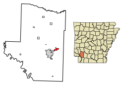
Perrytown, Arkansas | |
---|---|
Coordinates: 33°41′50″N93°32′02″W / 33.69722°N 93.53389°W | |
Country | United States |
State | Arkansas |
County | Hempstead |
Area | |
• Total | 1.41 sq mi (3.65 km2) |
• Land | 1.39 sq mi (3.61 km2) |
• Water | 0.01 sq mi (0.03 km2) |
Elevation | 292 ft (89 m) |
Population (2020) | |
• Total | 232 |
• Density | 166.43/sq mi (64.24/km2) |
Time zone | UTC-6 (Central (CST)) |
• Summer (DST) | UTC-5 (CDT) |
ZIP code | 71801 |
Area code | 870 |
FIPS code | 05-54680 |
GNIS feature ID | 2407102 [2] |
Perrytown is a town [3] in Hempstead County, Arkansas, United States. The population was 272 at the 2010 census. It is part of the Hope Micropolitan Statistical Area and was founded in 1959 by local entrepreneur Perry Campbell.
According to the United States Census Bureau, the city has a total area of 1.5 square miles (3.9 km2), all land.
Census | Pop. | Note | %± |
---|---|---|---|
1970 | 148 | — | |
1980 | 282 | 90.5% | |
1990 | 248 | −12.1% | |
2000 | 255 | 2.8% | |
2010 | 272 | 6.7% | |
2020 | 232 | −14.7% | |
U.S. Decennial Census [4] |
As of the census [5] of 2000, there were 255 people, 119 households, and 82 families residing in the city. The population density was 164.9 inhabitants per square mile (63.7/km2). There were 128 housing units at an average density of 82.8 per square mile (32.0/km2). The racial makeup of the city was 87.45% White, 9.02% Black or African American, 0.39% Native American, 3.14% from other races. 4.31% of the population were Hispanic or Latino of any race.
There were 119 households, out of which 19.3% had children under the age of 18 living with them, 58.8% were married couples living together, 7.6% had a female householder with no husband present, and 30.3% were non-families. 26.9% of all households were made up of individuals, and 8.4% had someone living alone who was 65 years of age or older. The average household size was 2.14 and the average family size was 2.54.
In the city the population was spread out, with 16.9% under the age of 18, 9.8% from 18 to 24, 21.6% from 25 to 44, 34.1% from 45 to 64, and 17.6% who were 65 years of age or older. The median age was 46 years. For every 100 females, there were 83.5 males. For every 100 females age 18 and over, there were 86.0 males.
The median income for a household in the city was $30,625, and the median income for a family was $38,438. Males had a median income of $31,250 versus $16,786 for females. The per capita income for the city was $23,059. About 11.5% of families and 10.5% of the population were below the poverty line, including 7.7% of those under the age of eighteen and 3.4% of those 65 or over.
It is within the Hope School District. [6] It operates Hope High School.
Hope is a city in Hempstead County in southwestern Arkansas, United States. Hope is the county seat of Hempstead County and the principal city of the Hope Micropolitan Statistical Area, which includes all of Hempstead and Nevada counties. As of the 2010 census the population was 10,095, and in 2019 the population was estimated at 9,599.
Hempstead County is a county located in the U.S. state of Arkansas. As of the 2020 census, the population was 20,065, down from 22,609 at the 2010 census. The county seat is Hope. Hempstead County is Arkansas's fourth county, formed on December 15, 1818, alongside Clark and Pulaski counties. The county is named for Edward Hempstead, a delegate to the U.S. Congress from the Missouri Territory, which included present-day Arkansas at the time. It is an alcohol prohibition or dry county.
Good Hope is a city in Cullman County, Alabama, United States. As of the 2010 census, the population of the city was 2,264. It incorporated in April 1962.
Norfork is a city in Baxter County, Arkansas, United States. The population was 550 at the 2010 census.
Kibler is a city in Crawford County, Arkansas, United States. It is part of the Fort Smith, Arkansas-Oklahoma Metropolitan Statistical Area. As of the 2010 Census the population was 961.
Blevins is a city in Hempstead County, Arkansas, United States. The population was 315 at the 2010 census, down from 365 in 2000. It is part of the Hope Micropolitan Statistical Area.
Fulton is a town in Hempstead County, Arkansas, United States. The population was 201 at the 2010 census. It is part of the Hope Micropolitan Statistical Area. The community is named after steamboat inventor Robert Fulton.
McCaskill is a town in Hempstead County, Arkansas, United States. The population was 96 at the 2010 census. It is part of the Hope Micropolitan Statistical Area.
McNab is a town in Hempstead County, Arkansas, United States. The population was 68 at the 2010 census, up from 37 in 2000. It is part of the Hope Micropolitan Statistical Area.
Oakhaven is a town in Hempstead County, Arkansas, United States. The population was 63 at the 2010 census. It is part of the Hope Micropolitan Statistical Area.
Ozan is a town in Hempstead County, Arkansas, United States. The population was 85 at the 2010 census. It is part of the Hope Micropolitan Statistical Area.
Patmos is a town in Hempstead County, Arkansas, United States. The population was 64 at the 2010 census. It bears the same name as the Greek island of Patmos.
Washington is a city in Ozan Township, Hempstead County, Arkansas, United States. The population was 180 at the 2010 census, up from 148 in 2000. It is part of the Hope Micropolitan Statistical Area. The city is home to Historic Washington State Park.
Hartman is a city in Johnson County, Arkansas, United States. The population was 519 at the 2010 census.
Lewisville is a city in Lafayette County, Arkansas, United States. The population was 1,280 at the 2010 census. It is the county seat of Lafayette County.
Bluff City is an unincorporated town in Nevada County, Arkansas, United States. The population was 158 at the 2000 census. It is part of the Hope Micropolitan Statistical Area.
Pottsville is a city in Pope County, Arkansas, United States. As of the 2020 census the population was 3,140. It is part of the Russellville Micropolitan Statistical Area.
Madison is a city in St. Francis County, Arkansas, United States. The population was 769 at the 2010 census, down from 987 in 2000.
Garden City Park is a hamlet and census-designated place (CDP) located in the Town of North Hempstead in Nassau County, New York, on Long Island. It's a suburb of New York City, located approximately 20 miles (32 km) from Midtown Manhattan. The population was 7,806 at the 2010 census.
South Hempstead is a hamlet and census-designated place (CDP) in the Town of Hempstead in Nassau County, on Long Island, in New York, United States. The population was 3,406 at the time of the 2020 census.