Emmet, Arkansas

Last updated

Emmet, Arkansas
Hempstead County and Nevada County Arkansas Incorporated and Unincorporated areas Emmet Highlighted 0521610.svg
Location of Emmet in Hempstead County and Nevada County, Arkansas.
Coordinates: 33°43′22″N93°27′57″W / 33.72278°N 93.46583°W / 33.72278; -93.46583
Country United States
State Arkansas
Counties Nevada, Hempstead
Area
[1]
  Total1.46 sq mi (3.79 km2)
  Land1.44 sq mi (3.73 km2)
  Water0.02 sq mi (0.06 km2)
Elevation
[2]
305 ft (93 m)
Population
 (2020)
  Total415
  Density287.79/sq mi (111.13/km2)
Time zone UTC-6 (Central (CST))
  Summer (DST) UTC-5 (CDT)
ZIP code
71835
Area code 870
FIPS code 05-21610
GNIS feature ID2403565 [2]

Emmet is a city in Nevada and Hempstead counties in the U.S. state of Arkansas. [3] It is located at the intersection of U.S. Highway 67 and Arkansas Highway 299 in the Arkansas Timberlands region of southwest Arkansas. It is part of the larger Ark-La-Tex tri-state region. As of the 2010 census, the population of Emmet was 518. [4]

Contents

History

The area around Emmet had long been inhabited by the Caddo people, prior to European colonization of the Americas. [5] [6] It consisted of gently rolling hills and prairies, interspersed with dense timber and fertile lowlands.

By the time of the Louisiana Purchase, the natural fauna was being removed in favor of more profitable crops. Wildlife that had been an important sustenance for the Natives was also being removed, and over time the Caddo population was greatly diminished.

In the years following Arkansas statehood, settlers began flowing steadily in. Some were following the Southwest Trail to Fulton on the Red River, while others saw opportunity in the area where Emmet would be established.

In 1837, Martin Edwards secured one of the first land patents in Arkansas. His property encompassed the area that would include the community of Burkville, precursor to the city of Emmet.

Geography

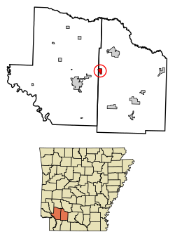
Emmet is located in western Nevada County. A small portion of the city extends west into Hempstead County.

The city is situated near the headwaters of the Terre Rouge Creek watershed which meanders northeastward for 17 miles (27 km) before joining the Little Missouri River at a point 11 miles (18 km) east of Prescott and 6 miles (10 km) northwest of Reader. The Prairie d'Ane is 8 miles (13 km) northeast of Emmet, and the Prairie de Roan is 8 miles (13 km) to the southwest. Both prairies were noted by Robert T. Hill during the Arkansas Geological Survey of 1888. [7]

U.S. Highway 67 passes through the northwest side of Emmet, leading northeast 8 miles (13 km) to Prescott and southwest the same distance to Hope. Arkansas Highway 299 passes through the center of Emmet, leading east 24 miles (39 km) to Bluff City and west 3 miles (5 km) to Interstate 30, that highway's closest access to Emmet.

According to the United States Census Bureau, Emmet has a total area of 1.5 square miles (3.9 km2), of which 0.02 square miles (0.06 km2), or 1.43%, are water. [4]

Demographics

Historical population
CensusPop.Note
1900 277
1910 270−2.5%
1920 42055.6%
1930 387−7.9%
1940 46520.2%
1950 4823.7%
1960 474−1.7%
1970 433−8.6%
1980 4759.7%
1990 446−6.1%
2000 50613.5%
2010 5182.4%
2020 415−19.9%
U.S. Decennial Census [8]
2018 Estimate [9]

As of the census [10] of 2000, there were 506 people, 186 households, and 129 families residing in the city. The population density was 333.4 inhabitants per square mile (128.7/km2). There were 220 housing units at an average density of 145.0 per square mile (56.0/km2). The racial makeup of the city was 77.67% White, 20.16% Black or African American, 0.40% Native American, 0.20% from other races, and 1.58% from two or more races. 0.40% of the population were Hispanic or Latino of any race.

There were 186 households, out of which 39.8% had children under the age of 18 living with them, 46.8% were married couples living together, 16.7% had a female householder with no husband present, and 30.6% were non-families. 26.3% of all households were made up of individuals, and 10.8% had someone living alone who was 65 years of age or older. The average household size was 2.72 and the average family size was 3.31.

In the city, the population was spread out, with 32.2% under the age of 18, 7.5% from 18 to 24, 30.4% from 25 to 44, 18.8% from 45 to 64, and 11.1% who were 65 years of age or older. The median age was 32 years. For every 100 females, there were 98.4 males. For every 100 females age 18 and over, there were 85.4 males.

The median income for a household in the city was $22,386, and the median income for a family was $26,250. Males had a median income of $24,107 versus $22,250 for females. The per capita income for the city was $11,726. About 30.0% of families and 33.4% of the population were below the poverty line, including 47.4% of those under age 18 and 20.0% of those age 65 or over.

Education

Public education for elementary and secondary school students is available from the Blevins School District, which leads to graduation from Blevins High School.

On July 1, 2004, the Emmet School District consolidated into the Blevins School District. [11] Emmet Elementary School and Emmet High School were formerly in operation. [12] [13]

Notable places

National Register

Commerce

Ark-La Village

In 1959, Arkansas Louisiana Gas Company opened a western-themed tourist attraction at the direction of Wilton R. Stephens, founder of Stephens Inc. [20] and Arkla Village. [21] [22] Ark-La Village was a re-creation of an 1880s western settlement where patrons could participate in the "daily life" of early pioneers. It was located on the company's property inside Emmet's northern city limits.

When first constructed, the "village" featured a saloon and general store, a livery stable, and a museum. Other attractions included a miniature train ride, a paddlewheel boat ride, a bowling alley, a restaurant, and a "jail" where comical, behind-the-bars photos could be taken. [23] Connected with the village was a factory that built horse-drawn carriages and horse saddles. [24]

In 1961, a shooting roundup was held and Harold M. Terry was the invited marksman. [25]

Though popular with tourists and local citizens, it was the traffic along U.S. Highway 67 between Little Rock and Dallas that provided Ark-La Village with most of its patrons. [26] That customer base was lost when the final section of Interstate 30 was completed in 1972. As a result, the village was closed in the early 1970s, with the restaurant and bowling alley closing a few years later.

In the following years, some portions of the property have been donated to the city of Emmet. Re-development has included a new city park and a building for public meetings.

Media

Emmet is served by the Hope Prescott News, a local paper owned by a partnership of Mark Keith and Wendell Hoover. The Hope Star and the Nevada County Picayune, owned by GateHouse Media, closed in 2019. Larger newspapers that serve the area include the Arkansas Democrat-Gazette , the Texarkana Gazette , and the Shreveport Times .

Local radio stations include KHPA (104.9 MHz FM) and KTPA (1370 kHz AM). In addition, the city is served by radio and television stations from Little Rock, and Shreveport.

A variety of telephone, cable TV, and internet providers are available to subscribers in Emmet, including SWARK.Today (Southwest Arkansas), Hope-Prescott.com, a local internet-news web site. [27]

Infrastructure

Notable person

Related Research Articles

<span class="mw-page-title-main">Hope, Arkansas</span> City in Arkansas, United States

Hope is a city in Hempstead County in southwestern Arkansas, United States. Hope is the county seat of Hempstead County and the principal city of the Hope Micropolitan Statistical Area, which includes all of Hempstead and Nevada counties. As of the 2010 census the population was 10,095, and in 2019 the population was estimated at 9,599.

<span class="mw-page-title-main">Randolph County, Arkansas</span> County in Arkansas, United States

Randolph County is located between the Ozark Mountains and Arkansas Delta in the U.S. state of Arkansas. The county is named for John Randolph, a U.S. senator from Virginia influential in obtaining congressional approval of the Louisiana Purchase, which includes today's Randolph County. Created as Arkansas's 32nd county on October 29, 1835, Randolph County has two incorporated cities, including Pocahontas, the county seat and most populous city. The county is also the site of numerous unincorporated communities and ghost towns.

<span class="mw-page-title-main">Nevada County, Arkansas</span> County in Arkansas, United States

Nevada County is a county located in the southwestern part of the U.S. state of Arkansas. As of the 2020 Census, the population was 8,310, less than half of its peak in 1920. The county seat is Prescott. Nevada County is Arkansas's 63rd county, formed during the Reconstruction era on March 20, 1871, from portions of Hempstead, Ouachita and Columbia counties. It was named after the state of Nevada because of the perceived similarity between their physical shapes; the Arkansas county's shape, inverted, roughly follows the same outline as the state's boundary. It is an alcohol prohibition or dry county.

<span class="mw-page-title-main">Hempstead County, Arkansas</span> County in Arkansas, United States

Hempstead County is a county located in the U.S. state of Arkansas. As of the 2020 census, the population was 20,065, down from 22,609 at the 2010 census. The county seat is Hope. Hempstead County is Arkansas's fourth county, formed on December 15, 1818, alongside Clark and Pulaski counties. The county is named for Edward Hempstead, a delegate to the U.S. Congress from the Missouri Territory, which included present-day Arkansas at the time. It is an alcohol prohibition or dry county.

<span class="mw-page-title-main">Clark County, Arkansas</span> County in Arkansas, United States

Clark County is a county located in the south-central part of the U.S. state of Arkansas. As of the 2020 census, the population was 21,446. The county seat is Arkadelphia. The Arkadelphia, AR Micropolitan Statistical Area includes all of Clark County.

<span class="mw-page-title-main">Arkadelphia, Arkansas</span> City in Arkansas, United States

Arkadelphia is a city in Clark County, Arkansas, United States. As of the 2020 census, the population was 10,380. The city is the county seat of Clark County. It is situated at the foothills of the Ouachita Mountains. Two universities, Henderson State University and Ouachita Baptist University, are located here. Arkadelphia was incorporated in 1857.

<span class="mw-page-title-main">Caddo Valley, Arkansas</span> Town in Arkansas, United States

Caddo Valley is a town in Clark County, Arkansas, United States. The population was 635 at the 2010 census.

<span class="mw-page-title-main">Fordyce, Arkansas</span> City in Arkansas, United States

Fordyce is a city in southeast Dallas County, Arkansas, United States. Its population has been decreasing since the 1980s when the town reached an all time high of 5,175. The population in 2020 was 3,396 down from 4,300 at the 2010 census, and from 4,799 in 2000.

<span class="mw-page-title-main">Blevins, Arkansas</span> City in Arkansas, United States

Blevins is a city in Hempstead County, Arkansas, United States. The population was 315 at the 2010 census, down from 365 in 2000. It is part of the Hope Micropolitan Statistical Area.

<span class="mw-page-title-main">Fouke, Arkansas</span> City in Arkansas, United States

Fouke is a city in Miller County, Arkansas, United States. It is part of the Texarkana, Texas - Texarkana, Arkansas Metropolitan Statistical Area. The population was 808 at the 2020 census.

<span class="mw-page-title-main">Norman, Arkansas</span> Town in Arkansas, United States

Norman is a town in Montgomery County, Arkansas, United States. It was known as Womble until 1925. The population was 303 at the 2020 census, down from 378 in 2010.

<span class="mw-page-title-main">Prescott, Arkansas</span> City and county seat in Nevada County, Arkansas, US

Prescott is a city and the county seat of Nevada County, Arkansas, United States. The community had a population of 3,296 at the 2010 census. Prescott is part of the Hope Micropolitan Statistical Area.

<span class="mw-page-title-main">Glenwood, Arkansas</span> City in Arkansas, United States

Glenwood is a city in Pike and Montgomery counties in Arkansas, United States. As of the 2020 census, its population was 2,068. The community is located along the Caddo River in the Ouachita Mountains.

<span class="mw-page-title-main">Ark-La-Tex</span> Region in the United States

The Ark-La-Tex is a socio-economic tri-state region where the Southern U.S. states of Arkansas, Louisiana, and Texas join together. The region contains portions of Northwest Louisiana, Northeast Texas, and South Arkansas as well as the extreme southeastern tip of Oklahoma, in McCurtain County, partly centered upon the Red River, which flows along the Texas–Oklahoma state line into Southwestern Arkansas and Northwest Louisiana.

<span class="mw-page-title-main">Caddo Parish, Louisiana</span> Parish in Louisiana, United States

Caddo Parish is a parish located in the northwestern corner of the U.S. state of Louisiana. According to the 2020 U.S. census, the parish had a population of 237,848. The parish seat is Shreveport, which developed along the Red River.

<span class="mw-page-title-main">Prescott and Northwestern Railroad</span>

The Prescott and Northwestern Railroad is a short-line railroad headquartered in Prescott, Arkansas. It is operated by Arkansas Midland Railroad, which is owned by Genesee & Wyoming.

<span class="mw-page-title-main">Hope, Arkansas micropolitan area</span> Micropolitan Statistical Area in Arkansas, United States

The Hope Micropolitan Statistical Area, as defined by the United States Census Bureau, is an area consisting of two counties in the U.S. state of Arkansas, anchored by the city of Hope.

<span class="mw-page-title-main">Arkansas Highway 29</span> State highway in Arkansas, United States

Arkansas Highway 29 is a state highway that extends 77.2 miles (124.2 km) in South Arkansas. It runs north from the Louisiana state line to its terminus at AR 301 in Antoine. It is intersected by many major thoroughfares including Interstate 30. Part of the highway is known as Bill Clinton Drive.

<span class="mw-page-title-main">Arkansas Highway 299</span> State highway in Arkansas, United States

Highway 299 is a north–south state highway in Arkansas. The route of 26.40 miles (42.49 km) runs from Interstate 30 to AR 24 in White Oak Lake State Park. The route is two–lane, undivided.

<span class="mw-page-title-main">Arkansas Highway 368</span> State highway in Arkansas, United States

Highway 368 is an east–west state highway in South Arkansas. The route of 6.90 miles (11.10 km) runs essentially as a northern loop of Arkansas Highway 24 through Reader while Highway 24 runs more southerly through Bluff City. The route is maintained by the Arkansas State Highway and Transportation Department (AHTD).

References

  1. "2020 U.S. Gazetteer Files". United States Census Bureau. Retrieved October 29, 2021.
  2. 1 2 U.S. Geological Survey Geographic Names Information System: Emmet, Arkansas
  3. "Emmet". Arkansas Municipal League - Local.Arkansas.Gov.
  4. 1 2 "Geographic Identifiers: 2010 Demographic Profile Data (G001): Emmet city, Arkansas". American Factfinder. U.S. Census Bureau. Retrieved April 18, 2017.[ dead link ]
  5. "Life different when Caddo Indians were here". John Miller, Nevada County Picayune, Wednesday, March 3, 2004. Archived from the original on February 23, 2016. Retrieved February 16, 2016.
  6. "Archaelogical site". Nevada County Depot and Museum - DeoptMuseum.org.
  7. "Lexicon of Geologic Names of the United States". United States Department of the Interior - R.T. Hill, 1888 (Ark. Geol. Surv. Ann. Rept. 1888, vol. 2, pp. 32-33, 46-47, 188). 1938.
  8. "Census of Population and Housing". Census.gov. Retrieved June 4, 2015.
  9. "Population Estimates". United States Census Bureau . Retrieved June 8, 2018.
  10. "U.S. Census website". United States Census Bureau . Retrieved January 31, 2008.
  11. "ConsolidationAnnex_from_1983.xls Archived 2015-09-12 at the Wayback Machine ." Arkansas Department of Education. Retrieved on April 25, 2018.
  12. "2009-2010 Emmet Elementary School ACSIP Plan" (PDF). Blevins School District.
  13. "2009-2010 Emmet High School ACSIP Plan" (PDF). Blevins School District.
  14. "B&P Lumber Sales LLC". B&P Lumber Sales, LLC - BAndPLumberSalesLLC.com. Archived from the original on April 20, 2016. Retrieved April 9, 2016.
  15. "B & P Pattern Lumber Sales, LLC". B & P Pattern Lumber Sales, LLC - EmmetLumber.com. Archived from the original on March 22, 2016. Retrieved April 9, 2016.
  16. "Company Overview of CenterPoint Energy Arkla". Bloomberg L.P. - Investing.BusinessWeek.com. Archived from the original on May 23, 2014.
  17. "Emmet (Nevada and Hempstead Counties)". Steven Teske - The Encyclopedia of Arkansas History & Culture (paragraph #6).
  18. "MarketMaker Business Profile: Flahertys Fish Farm". Riverside Research - AR.FoodMarketMaker.com. Retrieved April 9, 2016.
  19. "Welcome To Flaherty's Fish Farm!". Flaherty's Fish Farm - FlahertyFishFarm.com. Archived from the original on April 24, 2016. Retrieved April 9, 2016.
  20. "W. R. Stephens, Political Leader And Arkansas Investor, Dies at 84". Kurt Eichenwald - The New York Times Company, December 4, 1991.
  21. "W. R. Stephens Builds a Western Town at Emmet". Arkansas Gazette, July 12, 1959, p. 3C.
  22. "ARKLA, INC". Company-Histories.com.
  23. "Arkla Village". ArkansasAcer.Tripod.com. Retrieved September 26, 2014.
  24. "Down In Arkansas, Horse-And-Buggy Town". Horace Sutton, Shirley and Bob Sloane, St. Petersburg Times - March 27, 1960 (p.12-D).
  25. "Arkla Village Roundup to Feature Crack Shot Capt. Harold M. Terry". Hope Star . Retrieved September 26, 2014.
  26. Hanley, Ray; Hanley, Steve (1999). A Journey Through Arkansas: Historic U.S. Highway 67. Ray Hanley, Steve Hanley, Arcadia Publishing, 1999 (p.112). ISBN   9780738500522.
  27. "Hope-Prescott.com".

Historic photographs