This article includes a list of references, related reading, or external links, but its sources remain unclear because it lacks inline citations .(February 2025) |
This article is a list of rivers in the U.S. state of Arkansas.
This article includes a list of references, related reading, or external links, but its sources remain unclear because it lacks inline citations .(February 2025) |
This article is a list of rivers in the U.S. state of Arkansas.
This list is arranged by drainage basin, with respective tributaries indented under each larger stream's name.


This section's use of external links may not follow Wikipedia's policies or guidelines.(February 2025) |
Rivers are measured by their mean annual flow of water in cubic feet per second (cuft/s). 1 cubic foot per second equals 0.028 m3/s.
| River | Flow | Location of monitoring station | Notes | |
|---|---|---|---|---|
| cu ft/s | m3/s | |||
| Mississippi River | 671,500 | 19,010 | near Vicksburg, Mississippi | |
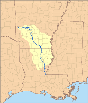
| Arkansas River | 47,970 | 1,358 | Murray Dam, near Little Rock | |
| White River | 26,760 | 758 | near De Valls Bluff | |
| Red River | 19,230 | 545 | near Spring Bank | |
| Ouachita River | 11,012 | 311.8 | near Louisiana border | |
| St. Francis | 10,000 | 280 | below junction with L'Anguille River | estimated from limited data from US Army Corps of Engineers. See notes, below |
| Black River | 9,893 | 280.1 | near Elgin Ferry | |
| Little River | 4,621 | 130.9 | near Millwood Lake | no measurement gauge nearby; probably 1,000–2,000 cu ft/s (28–57 m3/s) higher flow |
| Current River | 2,802 | 79.3 | near Doniphan, Missouri | |
| Saline River | 2,629 | 74.4 | near Rye | |
| Little Red River | 1,777 | 50.3 | near Dewey | |
| Spring River | 1,432 | 40.5 | near Imboden | |
| Buffalo River | 1,379 | 39.0 | near Harriet | |
| Cache River | 1,369 | 38.8 | near Cotton Plant | |
| Bayou Bartholomew | 1,221 | 34.6 | near Portland | |
| Eleven Point River | 1,157 | 32.8 | near Ravenden Springs | |
| L'Anguille River | 1,085 | 30.7 | near Palestine | |
| Petit Jean River | 828 | 23.4 | near Danville | |
| Crooked Creek | 669 | 18.9 | near Yellville | |
| Illinois River | 622 | 17.6 | near Siloam Springs | larger downstream in Oklahoma |
| Kings River | 582 | 16.5 | near Berryville | |
| Mulberry River | 557 | 15.8 | near Mulberry | |
| Lee Creek | 531 | 15.0 | near Van Buren | |
| Big Piney Creek | 481 | 13.6 | near Dover | |
| Smackover Creek | 415 | 11.8 | near Smackover | |
| Saline River | 385 | 10.9 | near Lockesburg | |
| Illinois Bayou | 379 | 10.7 | near Scottsville | |
| Mammoth Spring | 351 | 9.9 | near Mammoth Spring | |
| War Eagle Creek | 295 | 8.4 | near Hindsville | |
| Antoine Creek | 278 | 7.9 | near Antoine | |
| Cadron Creek | 271 | 7.7 | near Guy | |
| Caddo River | 266 | 7.5 | near Caddo Gap | upper course, larger downstream |
| West Fork Point Remove Creek | 257 | 7.3 | near Hattieville | |
| Moro Creek | 256 | 7.2 | near Fordyce | |
| Bayou Macon | 240 | 6.8 | near Eudora | |
| South Fork of Little Red River | 238 | 6.7 | near Clinton | |
| Cossatot River | 187 | 5.3 | near Vandervoort | upper course, larger downstream |
| Richland Creek | 179 | 5.1 | near Goshen | |
| West Fork White River | 166 | 4.7 | near Fayetteville | |
| Little Missouri River | 148 | 4.2 | near Langley | |
| James Fork | 147 | 4.2 | near Hackett | |
| Osage Creek | 134 | 3.8 | near Elm Springs | |
| Richland Creek | 118 | 3.3 | near Witts Spring | |
| Bear Creek | 108 | 3.1 | near Silver Hill | |
| Rolling Fork River | ? | No measurement gauge, but hundreds of cubic feet | ||
| Strawberry River | ? | No measurement gauge, but hundreds of cubic feet | ||
Notes and sources: There are two Richland Creeks and two Saline Rivers in Arkansas. Flow of rivers differs substantially between years and seasons. Source for all rivers except St. Francis is the "USGS Water-Data Report – 2012" at http://waterdata.usgs.gov/ar/nwis/current/?type=flow&group_key=basin_cd; The flow of the St. Francis River flow is estimated from US Army Corps of Engineers data at https://archive.today/20130708123645/http://w3.mvm.usace.army.mil/hydraulics/docs/historic/sfdata/sf13284d