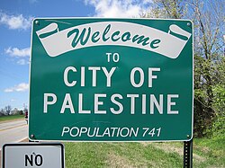
Palestine, Arkansas

Last updated

Palestine, Arkansas
Palestine AR 002.jpg
St. Francis County Arkansas Incorporated and Unincorporated areas Palestine Highlighted 0553150.svg
Location of Palestine in St. Francis County, Arkansas.
Coordinates: 34°58′11″N90°54′25″W / 34.96972°N 90.90694°W / 34.96972; -90.90694
Country United States
State Arkansas
County St. Francis
Area
  Total3.33 sq mi (8.62 km2)
  Land3.31 sq mi (8.56 km2)
  Water0.02 sq mi (0.06 km2)
Elevation
[1]
213 ft (65 m)
Population
 (2020)
  Total506
  Density153.10/sq mi (59.11/km2)
Time zone UTC-6 (Central (CST))
  Summer (DST) UTC-5 (CDT)
FIPS code 05-53150
GNIS feature ID2404462 [1]

Palestine is a town in St. Francis County, Arkansas, United States, along the L'Anguille River. The population was 681 at the 2010 census, a decline from 741 in 2000.[ citation needed ]

Contents

Geography

According to the United States Census Bureau, the town has a total area of 3.2 square miles (8.3 km2), of which 3.2 square miles (8.3 km2) is land and 0.04 square miles (0.10 km2) (0.62%) is water.

Demographics

Historical population
CensusPop.Note
1890 163
1900 19620.2%
1910 173−11.7%
1920 29771.7%
1930 209−29.6%
1940 34565.1%
1950 42021.7%
1960 53226.7%
1970 75541.9%
1980 97629.3%
1990 711−27.2%
2000 7414.2%
2010 681−8.1%
2020 506−25.7%
U.S. Decennial Census [2]

As of the census [3] of 2000, there were 741 people, 299 households, and 209 families residing in the town. The population density was 230.2 inhabitants per square mile (88.9/km2). There were 321 housing units at an average density of 99.7 per square mile (38.5/km2). The racial makeup of the city was 85.96% White, 13.23% Black or African American, 0.13% from other races, and 0.67% from two or more races. 0.27% of the population were Hispanic or Latino of any race.

There were 299 households, out of which 33.4% had children under the age of 18 living with them, 52.2% were married couples living together, 15.1% had a female householder with no husband present, and 30.1% were non-families. 27.1% of all households were made up of individuals, and 15.4% had someone living alone who was 65 years of age or older. The average household size was 2.48 and the average family size was 3.01.

In the town, the population was spread out, with 26.7% under the age of 18, 9.6% from 18 to 24, 26.2% from 25 to 44, 23.3% from 45 to 64, and 14.2% who were 65 years of age or older. The median age was 36 years. For every 100 females, there were 81.6 males. For every 100 females age 18 and over, there were 81.0 males.

The median income for a household in the town was $24,904, and the median income for a family was $36,023. Males had a median income of $28,661 versus $18,816 for females. The per capita income for the town was $14,462. About 16.7% of families and 17.2% of the population were below the poverty line, including 17.5% of those under age 18 and 19.0% of those age 65 or over.

Education

Public education for elementary and secondary school students is available from the Palestine–Wheatley School District, which results in graduation from Palestine–Wheatley High School. It was established by the July 1, 1987, merger of the Palestine School District and the Wheatley School District. [4]

Related Research Articles

<span class="mw-page-title-main">St. Francis County, Arkansas</span> County in Arkansas, United States

St. Francis County is a county in the U.S. state of Arkansas. As of the 2020 census, the population was 23,090. The county seat is Forrest City.

<span class="mw-page-title-main">Lakeview, Arkansas</span> Place in Arkansas, United States

Lakeview is a city in Baxter County, Arkansas, United States. The population was 741 at the 2010 census.

<span class="mw-page-title-main">Lead Hill, Arkansas</span> Town in Arkansas, United States

Lead Hill is a town in Boone County, Arkansas, United States. The population was 271 at the 2010 census. It is part of the Harrison Micropolitan Statistical Area.

<span class="mw-page-title-main">Sunset, Arkansas</span> Town in Arkansas, United States

Sunset is a town in Crittenden County, Arkansas, United States. The population was 198 at the 2010 census.

<span class="mw-page-title-main">Mount Pleasant, Arkansas</span> Town in Arkansas, United States

Mount Pleasant is a town in Izard County, Arkansas, United States. As of the 2020 census, the town population was 353.

<span class="mw-page-title-main">Bluff City, Arkansas</span> Town in Arkansas, United States

Bluff City is an unincorporated town in Nevada County, Arkansas, United States. The population was 158 at the 2000 census. It is part of the Hope Micropolitan Statistical Area.

<span class="mw-page-title-main">Pottsville, Arkansas</span> City in Arkansas, United States

Pottsville is a city in Pope County, Arkansas, United States. As of the 2020 census the population was 3,140. It is part of the Russellville Micropolitan Statistical Area.

<span class="mw-page-title-main">Colt, Arkansas</span> Town in Arkansas, United States

Colt is a town and an unincorporated area in St. Francis County, Arkansas, United States. The population was 378 at the 2010 census, an increase from 368 in 2000.

<span class="mw-page-title-main">Wheatley, Arkansas</span> Town in Arkansas, United States

Wheatley is a town in southwest St. Francis County, Arkansas, United States. The population was 279 at the 2020 census, down from 355 in 2010.

<span class="mw-page-title-main">Shirley, Arkansas</span> Town in Arkansas, United States

Shirley is a town in northeast Van Buren County, Arkansas, United States, along the Middle Fork of the Little Red River. A one-time railroad outpost, the community today is oriented toward agriculture and recreational activities due to the river and Greers Ferry Lake. The population was 223 at the 2010 census.

<span class="mw-page-title-main">New Palestine, Indiana</span> Town in Indiana, United States

New Palestine is a town in Sugar Creek Township, Hancock County, Indiana, along Sugar Creek. The population was 2,055 at the 2010 census.

<span class="mw-page-title-main">St. Francis, Maine</span> Town in the state of Maine, United States

St. Francis is a town in Aroostook County, Maine, United States on the Canada–United States border at the junction of the St. Francis River and the Saint John River. The population was 438 at the 2020 census. First settled by English speakers from southern Maine, the original population has been supplanted by French-speaking Acadians.

Otis is a town in Hancock County, Maine, United States. The population was 673 at the 2020 census.

<span class="mw-page-title-main">Searsmont, Maine</span> Town in the state of Maine, United States

Searsmont is a town in Waldo County, Maine, United States. The population was 1,400 at the 2020 census.

<span class="mw-page-title-main">Georgetown, Polk County, Wisconsin</span> Town in Wisconsin, United States

Georgetown is a town in Polk County, Wisconsin, United States. The population was 977 at the 2010 census. The unincorporated communities of Bunyan and Fox Creek are located in the town.

<span class="mw-page-title-main">Herman, Shawano County, Wisconsin</span> Town in Wisconsin, United States

Herman is a town in Shawano County, Wisconsin, United States. The population was 741 at the 2000 census. The unincorporated community of Lyndhurst is located in the town. The unincorporated community of Leopolis is also located partially within the town.

<span class="mw-page-title-main">Dupont, Wisconsin</span> Town in Wisconsin, United States

Dupont is a town in Waupaca County, Wisconsin, United States. The population was 741 at the 2000 census.

<span class="mw-page-title-main">Parish, New York</span> Town in New York, United States

Parish is a town in Oswego County, New York, United States. The population was 2,558 at the 2010 census.

The Town of Potosi is located in Grant County, Wisconsin, United States. The population was 831 at the 2000 census. The Village of Potosi and the unincorporated communities of British Hollow, Buena Vista, Rockville, and Van Buren are located in the town.

Hartland is a town in Somerset County, Maine, United States. The population was 1,705 at the 2020 census.

References

  1. 1 2 U.S. Geological Survey Geographic Names Information System: Palestine, Arkansas
  2. "Census of Population and Housing". Census.gov. Retrieved June 4, 2015.
  3. "U.S. Census website". United States Census Bureau . Retrieved January 31, 2008.
  4. "ConsolidationAnnex_from_1983.xls Archived 2015-09-12 at the Wayback Machine ." Arkansas Department of Education. Retrieved on October 13, 2017.