Barry County is a county located in the southwest portion of the U.S. state of Missouri. As of the 2010 Census, the population was 35,597. Its county seat is Cassville. The county was organized in 1835 and named after William Taylor Barry, a U.S. Postmaster General from Kentucky.

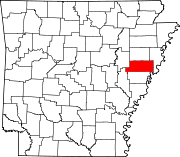
Hot Spring County is a county located in the U.S. state of Arkansas. As of the 2010 census, the population was 32,923. The county seat is Malvern. Hot Spring County was formed on November 2, 1829, from a portion of Clark County. It was named for the hot springs at Hot Springs, Arkansas, which were within its boundaries until Garland County was formed in 1874. It is an alcohol prohibition or dry county. However, there is no record of this law.

Chicot County is a county located in the U.S. state of Arkansas. As of the 2010 census, the population was 11,800. The county seat is Lake Village. Chicot County is Arkansas's tenth county, formed on October 25, 1823, and named after Point Chicot on the Mississippi River. It is part of the Arkansas Delta, lowlands along the river that have been historically important as an area for large-scale cotton cultivation.

Baxter County is a county in the U.S. state of Arkansas. As of the 2010 census, the county's population was 41,513. The county seat is Mountain Home. It is Arkansas's 66th county, formed on March 24, 1873, and named for Elisha Baxter, the tenth governor of Arkansas.

Shell Knob is a census-designated place (CDP) in White River Township in Barry County and Alpine Township in Stone County in the state of Missouri. The population was 1,379 at the 2010 census.

The Ozarks, also called the Ozark Mountains or Ozark Plateau, is a physiographic region in the U.S. states of Missouri, Arkansas, Oklahoma, and extreme southeastern Kansas. The Ozarks cover a significant portion of northern Arkansas and most of the southern half of Missouri, extending from Interstate 40 in Arkansas to the Interstate 70 in central Missouri.

The White River is a 722-mile (1,162 km) long river that flows through the U.S. states of Arkansas and Missouri. Originating in the Boston Mountains of northwest Arkansas, it flows northwards into southern Missouri, and then turns back into Arkansas, flowing southeast to its mouth at the Mississippi River.

The Ouachita Mountains, simply referred to as the Ouachitas, are a mountain range in western Arkansas and southeastern Oklahoma. They are formed by a thick succession of highly deformed Paleozoic strata constituting the Ouachita Fold and Thrust Belt, one of the important orogenic belts of North America. The Ouachitas continue in the subsurface to the southeast where they make a poorly understood connection with the Appalachians and to the southwest where they join with the Marathon area of West Texas. Together with the Ozark Plateaus, the Ouachitas form the U.S. Interior Highlands. The highest natural point is Mount Magazine at 2,753 feet.

U.S. Route 63 is a major 1,286-mile (2,070 km) north–south United States highway primarily in the Midwestern United States. The southern terminus of the route is at Interstate 20 in Ruston, Louisiana. The northern terminus is at U.S. Route 2 in Benoit, Wisconsin, about 60 miles (97 km) east of Duluth, Minnesota.

U.S. Route 278 is a parallel route of U.S. Route 78. It currently runs for 1,074 miles (1,728 km) from Hilton Head Island, South Carolina to Wickes, Arkansas at U.S. Route 71/U.S. Route 59. It is longer than its parent highway, US 78. US 278 passes through the states of South Carolina, Georgia, Alabama, Mississippi, and Arkansas. This highway passes through the cities and towns of Augusta, Covington, Atlanta, Powder Springs, Hiram, Dallas, Rockmart, and Cedartown, Georgia; Gadsden and Cullman, Alabama; Tupelo, Oxford, and Greenville, Mississippi; and Monticello and Hope, Arkansas.
Route 39 is a two-lane highway in southwest Missouri. Its northern terminus is at U.S. Route 54 between Collins and El Dorado Springs at the community of Cedar Springs; its southern terminus is at the Arkansas state line where it continues as Highway 221.

Lake Dardanelle is a major reservoir on the Arkansas River in Arkansas, USA. and is an integral part of the McClellan-Kerr Arkansas River Navigation System (MKARNS), which allows barge transportation from the Mississippi River to the Tulsa Port of Catoosa in northeastern Oklahoma. MKARNS went into service along its full length in 1971.

State Road 2 is a former east–west state highway in the Arkansas Timberlands and Lower Arkansas Delta. The route was approximately 195 miles (314 km), and ran from US Route 67 (US 67) in Texarkana east to cross the Mississippi River near Lake Village, continuing as Mississippi Highway 10. On July 1, 1931, the route was entirely replaced by US Highway 82 (US 82) by the American Association of State Highway Officials (AASHTO). The route was maintained by the Arkansas Highway Department (AHD), now known as the Arkansas Department of Transportation (ArDOT).

The geography of Arkansas varies widely. The state is covered by mountains, river valleys, forests, lakes, and bayous in addition to the cities of Arkansas. Hot Springs National Park features bubbling springs of hot water, formerly sought across the country for their healing properties. Crowley's Ridge is a geological anomaly rising above the surrounding lowlands of the Mississippi embayment.

The following outline is provided as an overview of and topical guide to the U.S. state of Arkansas:
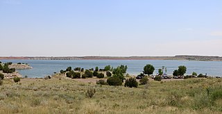
Lake Pueblo State Park is a state park located in Pueblo County, Colorado. It includes 60 miles (97 km) of shoreline and 10,000 acres (40 km2) of land. Activities it offers include two full-service marinas, recreational fishing, hiking, camping and swimming at a special swim beach.
The Spavinaw Water Project was a water project to provide water for Tulsa, Oklahoma.

Bruce Eugene Westerman is a Republican U.S. Representative for Arkansas' 4th congressional district. Previously, he served as the Majority Leader of the Arkansas House of Representatives.