Miller County is a county located in the southwestern corner of the U.S. state of Arkansas. As of the 2010 census, the population was 43,462. The county seat is Texarkana.

Cross County is a rural Northeast Arkansas county in the Arkansas Delta. Created as Arkansas's 53rd county on November 15, 1862, Cross County contains four incorporated municipalities, including Wynne, the county seat and most populous city. It is named for Confederate Colonel David C. Cross, a political leader in the area.

The Cache River is a tributary of the White River, 213 mi (343 km) long, in northeastern Arkansas in the United States. Its headwaters also drain a small portion of southeastern Missouri. Via the White River, the Cache is part of the Mississippi River watershed, placing the river and surrounding watershed in the Arkansas Delta.

The Battle of Bayou Fourche, also known as the Battle of Little Rock and the Engagement at Bayou Fourche, took place on September 10, 1863, in Pulaski County, Arkansas, and was the final battle of the Little Rock Campaign, also known as the Advance upon Little Rock, which began on August 1 to capture the capital. Union Major-General Frederick Steele's "Arkansas expedition," 15,000 strong, defeated Confederate Major-General Sterling Price's 7,749 District of Arkansas. The Confederate forces took up defensive positions in and around the city of Little Rock. The area of the battle was bisected by the Arkansas River, with the Bayou Fourche forming an additional obstacle to the south-east of Little Rock. Steele divided his army into two main sections in order to attack from both the east and south-east. There was fierce fighting at river crossing points and, following the crossing of the Bayou Fourche to the east of the city, the "Arkansas expedition" entered Little Rock and organized Confederate resistance collapsed. Price's army was able to escape capture.

The Fourche La Fave River is a tributary of the Arkansas River, approximately 151 miles (243 km) long, in western Arkansas in the United States. It drains part of the northern Ouachita Mountains west of Little Rock.

The Elbow River is a river in southern Alberta, Canada. It flows from the Canadian Rockies to the city of Calgary, where it merges into the Bow River.

Ballona Creek is an 8.5-mile (13.7 km) channelized stream in southwestern Los Angeles County, California, United States that was once a “year-round river lined with sycamores and willows.” In conjunction with neighboring Ballona Wetlands, Ballona Creek remains a “prime bird-watching spot for cormorants, owls, and migrating ducks and geese.”

The Cache River is a 92-mile-long (148 km) waterway in southernmost Illinois, in a region sometimes called Little Egypt. The basin spans 737 square miles (1,910 km2) and six counties: Alexander, Johnson, Massac, Pope, Pulaski and Union. Located at the convergence of four major physiographic regions, the river is part of the largest complex of wetlands in Illinois. The Cache River Wetlands — America's northernmost cypress/tupelo swamp — harbors 91 percent of the state's high quality swamp and wetland communities. It provides habitat for more than 100 threatened and endangered species in Illinois. In 1996, the Cache was designated a Wetland of International Importance by the Ramsar Convention.
The Fourche River is a tributary of the Black River in Northeast Arkansas and ending in Randolph County, Arkansas near Pocahontas at its confluence with the Black River. The source is the confluence of Fourche Creek and the west Fork of the Fourche Creek in Ripley County, Missouri. The Fourche River flows for 32.4 miles (52.1 km) in Missouri and Arkansas.

Daylighting can be defined as "opening up buried watercourses and restoring them to more natural conditions". An alternative definition refers to "the practice of removing streams from buried conditions and exposing them to the Earth's surface in order to directly or indirectly enhance the ecological, economic and/or socio-cultural well-being of a region and its inhabitants”. The term is used to refer to the restoration of an originally open-air watercourse, which had at some point been diverted below ground, back into an above-ground channel. Typically, the rationale behind returning the riparian environment of a stream, wash, or river to a more natural state is to reduce runoff, create habitat for species in need of it, or improve an area's aesthetics. In the UK, the practice is also known as deculverting.
The Galien River is a 30.0-mile-long (48.3 km) stream in the southwest region of the U.S. state of Michigan. The river begins at the outlet of Dayton Lake and flows in a predominantly westerly direction until it enters southeastern Lake Michigan at New Buffalo. The South Branch Galien River rises just north of the border with Indiana, at the confluence of Spring Creek and the Galena River, the latter rising in LaPorte County, Indiana.

The Little River is a tributary of the Red River, with a total length of 217 miles (349 km), 130 miles (210 km) within the Choctaw Indian Reservation in southeastern Oklahoma and 87 miles (140 km) in southwestern Arkansas in the United States. Via the Red, it is part of the watershed of the Mississippi River. Six large reservoirs impound the Little River and its tributaries. The drainage basin of the river totals 4,204 square miles (10,890 km2), 2,204 square miles (5,710 km2) in Oklahoma and 2,036 square miles (5,270 km2) in Arkansas. The Little River and its upper tributaries are popular for recreational canoeing and kayaking.
Back River is a tidal estuary in Baltimore County, Maryland, located about 2 miles (3 km) east of the city of Baltimore. The estuary extends from Essex, Maryland, southeast for about 8.8 miles (14.2 km) to the Chesapeake Bay. The watershed area is 39,075 acres (15,813 ha) and includes Essex Skypark Airport and the Back River Wastewater Treatment Plant. The river is shared between Essex, MD, Dundalk, MD, and Edgemere, MD
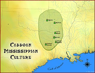
The Bluffton Mound Site is a Caddoan Mississippian culture archaeological site in Yell County, Arkansas on the Fourche La Fave River.

The Arkansas River Valley is a region in Arkansas defined by the Arkansas River in the western part of the state. Generally defined as the area between the Ozark and Ouachita Mountains, the River Valley is characterized by flat lowlands covered in fertile farmland and lakes periodically interrupted by high peaks. Mount Magazine, Mount Nebo, and Petit Jean Mountain compose the Tri-Peaks Region, a further subdivision of the River Valley popular with hikers and outdoors enthusiasts. In addition to the outdoor recreational activities available to residents and visitors of the region, the River Valley contains Arkansas's wine country as well as hundreds of historical sites throughout the area. It is one of six natural divisions of Arkansas.
The Flatside Wilderness is a 9,507-acre protected area in the U.S. state of Arkansas. It is one of six wilderness areas in the Ouachita National Forest and also the easternmost. Outdoor enthusiasts can enjoy the area in a number of ways, including an 8.9-mile section of the Ouachita National Recreation Trail.

The Arkansas Valley is a Level III ecoregion designated by the Environmental Protection Agency (EPA) in the U.S. states of Arkansas and Oklahoma. It parallels the Arkansas River between the flat plains of western Oklahoma and the Arkansas Delta, dividing the Ozarks and the Ouachita Mountains with the broad valleys created by the river's floodplain, occasionally interrupted by low hills, scattered ridges, and mountains. In Arkansas, the region is often known as the Arkansas River Valley, especially when describing the history and culture of the region.