According to the U.S. Census Bureau, the county has a total area of 724 square miles (1,880km2), of which 708 square miles (1,830km2) is land and 16 square miles (41km2) (2.2%) is water.[3]
U.S. Decennial Census[5] 1790–1960[6] 1900–1990[7] 1990–2000[8] 2010[9]
Age pyramid Van Buren County
2020 census
As of the 2020 census, the county had a population of 15,796. The median age was 50.2 years. 19.1% of residents were under the age of 18 and 27.2% of residents were 65 years of age or older. For every 100 females there were 98.0 males, and for every 100 females age 18 and over there were 96.5 males age 18 and over.[11][12]
<0.1% of residents lived in urban areas, while 100.0% lived in rural areas.[13]
There were 7,012 households in the county, of which 23.1% had children under the age of 18 living in them. Of all households, 49.2% were married-couple households, 19.9% were households with a male householder and no spouse or partner present, and 26.1% were households with a female householder and no spouse or partner present. About 32.3% of all households were made up of individuals and 18.1% had someone living alone who was 65 years of age or older.[11]
There were 9,668 housing units, of which 27.5% were vacant. Among occupied housing units, 79.8% were owner-occupied and 20.2% were renter-occupied. The homeowner vacancy rate was 2.9% and the rental vacancy rate was 10.6%.[11]
2000 census
As of the 2000 census,[14] there were 16,192 people, 6,825 households, and 4,804 families residing in the county. The population density was 23 peopleper square mile (8.9 people/km2). There were 9,164 housing units at an average density of 13 unitsper square mile (5.0 units/km2). The racial makeup of the county was 96.79% White, 0.31% Black or African American, 0.75% Native American, 0.25% Asian, 0.04% Pacific Islander, 0.37% from other races, and 1.48% from two or more races. 1.33% of the population were Hispanic or Latino of any race, but the percentage could increased 3 or 4 times by seasonal migrant laborers in the county's shiitake mushroom harvest and hospitality jobs provided by the Fairfield Bay resort hotel. [citation needed]
There were 6,825 households, out of which 25.20% had children under the age of 18 living with them, 59.10% were married couples living together, 7.70% had a female householder with no husband present, and 29.60% were non-families. 26.40% of all households were made up of individuals, and 14.40% had someone living alone who was 65 years of age or older. The average household size was 2.33 and the average family size was 2.79.
In the county, the population was spread out, with 21.50% under the age of 18, 6.60% from 18 to 24, 23.00% from 25 to 44, 25.50% from 45 to 64, and 23.30% who were 65 years of age or older. The median age was 44 years. For every 100 females there were 96.70 males. For every 100 females age 18 and over, there were 93.00 males.
The median income for a household in the county was $27,004, and the median income for a family was $32,284. Males had a median income of $25,821 versus $18,862 for females. The per capita income for the county was $16,603. About 11.60% of families and 15.40% of the population were below the poverty line, including 21.90% of those under age 18 and 10.60% of those age 65 or over.
Government
The Van Buren County Quorum Court meets at the courthouse annex, 1414 Hwy. 65 South in Clinton
The county government is a constitutional body granted specific powers by the Constitution of Arkansas and the Arkansas Code. The quorum court is the legislative branch of the county government and controls all spending and revenue collection. Representatives are called justices of the peace and are elected from county districts every even-numbered year. The number of districts in a county vary from nine to fifteen, and district boundaries are drawn by the county election commission. The Van Buren County Quorum Court has nine members.[15] Presiding over quorum court meetings is the county judge, who serves as the chief operating officer of the county. The county judge is elected at-large and does not vote in quorum court business, although capable of vetoing quorum court decisions.[16][17]
Van Buren County, Arkansas Elected countywide officials[18][19][20]
The composition of the Quorum Court following the 2024 elections is 7 Republicans and 2 Independents. Justices of the Peace (members) of the Quorum Court following the elections are:[21][22]
Additionally, the townships of Van Buren County are entitled to elect their own respective constables, as set forth by the Constitution of Arkansas. Constables are largely of historical significance as they were used to keep the peace in rural areas when travel was more difficult.[23] The township constables as of the 2024 elections are:[24][25]
Over the past few election cycles Van Buren County, like all of the traditionally secessionist and Democratic Upland South, has trended heavily towards the GOP. The last Democrat to carry this county was Bill Clinton in 1996.
United States presidential election results for Van Buren County, Arkansas[26]
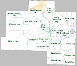
Townships in Van Buren County, Arkansas, as of 2010
Townships in Arkansas are the divisions of a county. Each township includes unincorporated areas; some may have incorporated cities or towns within part of their boundaries. Arkansas townships have limited purposes in modern times. However, the United States census does list Arkansas population based on townships (sometimes referred to as "county subdivisions" or "minor civil divisions"). Townships are also of value for historical purposes in terms of genealogical research. Each town or city is within one or more townships in an Arkansas county based on census maps and publications. The townships of Van Buren County are listed below; listed in parentheses are the cities, towns, and/or census-designated places that are fully or partially inside the township.[27][28]
This page is based on this Wikipedia article Text is available under the CC BY-SA 4.0 license; additional terms may apply. Images, videos and audio are available under their respective licenses.