North Little Rock, Arkansas

Last updated

North Little Rock
City of North Little Rock
Arkansas River, Looking Across To North Little Rock 423757092.jpg
Flag of North Little Rock, Arkansas.png
Logo of North Little Rock, Arkansas.png
Motto: 
“Up for Something!”
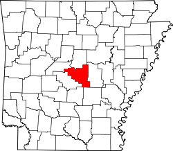
Pulaski County Arkansas Incorporated and Unincorporated areas North Little Rock Highlighted 0550450.svg
Location of North Little Rock in Pulaski County, Arkansas
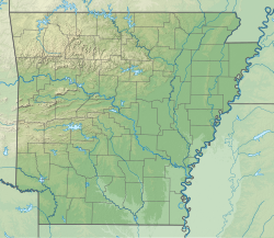
USA Arkansas relief location map.svg
Red pog.svg
North Little Rock
Location in the Arkansas
Coordinates: 34°46′51″N92°15′25″W / 34.78083°N 92.25694°W / 34.78083; -92.25694
Country Flag of the United States.svg  United States
State Flag of Arkansas.svg  Arkansas
County Pulaski
Township Hill
FoundedApril 18, 1871 (1871-04-18)
Incorporated July 17, 1901 (1901-07-17)
Named for Little Rock, Arkansas
Government
  Type Mayor–Council
   Mayor Terry Hartwick
   Council North Little Rock City Council
Area
[1]
   City
56.20 sq mi (145.55 km2)
  Land53.04 sq mi (137.38 km2)
  Water3.15 sq mi (8.16 km2)
Elevation
[2]
256 ft (78 m)
Population
 (2020)
   City
64,591
  RankUS: 524th
  Density1,217.69/sq mi (470.15/km2)
   Urban
431,388 (US: 88th)
   Metro
729,135 (US: 75th)
Time zone UTC−6 (CST)
  Summer (DST) UTC−5 (CDT)
ZIP codes
72114-119, 721124, 72190, 72199
Area code 501
FIPS code 05-50450
GNIS feature ID2404393 [2]

North Little Rock (often abbreviated "NLR") is a city in Pulaski County, Arkansas, United States. Located on the north side of the Arkansas River, it is the twin city of Little Rock. In the late nineteenth century, it was annexed by Little Rock for a period, but regained its independence in the early 20th century. The population was 64,591 at the 2020 Census, making it the seventh-most populous city in Arkansas.

Contents

The city has invested in significant beautification efforts since the late 20th century. Young families and professionals have shown new interest in this area. The Argenta Historic District in Downtown is one of a number of areas that have developed as thriving entertainment districts offering theaters, fine dining, bars, gastropubs, and boutiques.

It is also home to Dickey-Stephens Park, which hosts the Arkansas Travelers minor league baseball team. Simmons Bank Arena is the metropolitan area's main entertainment venue. Farther west is Burns Park, one of the largest municipal parks in the United States.

History

Originally named Argenta, Arkansas, the community was founded on April 18, 1871. [3] In 1890, the city of Little Rock annexed Argenta as part of its eighth ward, preempting a competing petition to incorporate.

As part of a plan to reclaim its independence, Argenta was incorporated on July 17, 1901, as the town of "North Little Rock". By 1904, the state's supreme court allowed North Little Rock to annex what was left of the ward. It readopted the name Argenta in 1906, only to revert to North Little Rock in October 1917. Evidence of the old town can still be found in the North Little Rock City Hall (built in 1914) which contains plaques referring to Argenta, and incorporates "C of A" (i.e. City of Argenta) ornamental features. [4]

Geography

According to the United States Census Bureau, the city has a total area of 47.0 square miles (122 km2), of which 44.8 square miles (116 km2) is land and 2.2 square miles (5.7 km2) (4.58%) is water.

Neighborhoods

Climate

The climate in this area is characterized by hot, humid summers and generally mild to cool winters. According to the Köppen Climate Classification system, North Little Rock has a humid subtropical climate, abbreviated "Cfa" on climate maps. [5]

North Little Rock has a humid subtropical climate with long, hot, and sunny summers and mild, wet winters with little snow. January on average is the coldest month, while July is typically the warmest, though occasionally August can claim the distinction. [6] The overall yearly average temperature is 62.5 degrees. Precipitation averages 45.79 inches a year, with winter and spring tending to be wetter than summer and autumn. [7] Severe thunderstorms can occur, especially during the Spring. On April 25, 2011, during that year's Super Outbreak, a possible tornado struck the US Air Force base in the city.

Climate data for Little Rock (Clinton National Airport), 1991−2020 normals, [a] extremes 1879−present [b]
MonthJanFebMarAprMayJunJulAugSepOctNovDecYear
Record high °F (°C)83
(28)
87
(31)
91
(33)
95
(35)
98
(37)
107
(42)
112
(44)
114
(46)
106
(41)
98
(37)
86
(30)
81
(27)
114
(46)
Mean maximum °F (°C)72.0
(22.2)
75.8
(24.3)
82.2
(27.9)
86.2
(30.1)
91.3
(32.9)
96.2
(35.7)
100.2
(37.9)
101.1
(38.4)
96.2
(35.7)
89.2
(31.8)
79.6
(26.4)
72.8
(22.7)
102.4
(39.1)
Mean daily maximum °F (°C)50.5
(10.3)
55.2
(12.9)
63.7
(17.6)
72.8
(22.7)
80.5
(26.9)
88.2
(31.2)
91.7
(33.2)
91.5
(33.1)
85.1
(29.5)
74.2
(23.4)
61.9
(16.6)
52.6
(11.4)
72.3
(22.4)
Daily mean °F (°C)40.7
(4.8)
44.7
(7.1)
52.7
(11.5)
61.4
(16.3)
69.9
(21.1)
78.0
(25.6)
81.4
(27.4)
80.8
(27.1)
74.0
(23.3)
62.6
(17.0)
51.1
(10.6)
43.0
(6.1)
61.7
(16.5)
Mean daily minimum °F (°C)30.9
(−0.6)
34.2
(1.2)
41.8
(5.4)
50.1
(10.1)
59.3
(15.2)
67.7
(19.8)
71.2
(21.8)
70.1
(21.2)
62.9
(17.2)
50.9
(10.5)
40.2
(4.6)
33.3
(0.7)
51.0
(10.6)
Mean minimum °F (°C)16.4
(−8.7)
20.5
(−6.4)
26.6
(−3.0)
36.9
(2.7)
47.2
(8.4)
59.8
(15.4)
65.6
(18.7)
63.8
(17.7)
50.4
(10.2)
37.1
(2.8)
26.4
(−3.1)
20.3
(−6.5)
13.6
(−10.2)
Record low °F (°C)−8
(−22)
−12
(−24)
11
(−12)
28
(−2)
38
(3)
46
(8)
54
(12)
52
(11)
37
(3)
27
(−3)
10
(−12)
−1
(−18)
−12
(−24)
Average precipitation inches (mm)3.50
(89)
3.97
(101)
4.96
(126)
5.59
(142)
5.08
(129)
3.55
(90)
3.33
(85)
3.16
(80)
3.01
(76)
4.47
(114)
4.72
(120)
5.08
(129)
50.42
(1,281)
Average snowfall inches (cm)1.1
(2.8)
1.6
(4.1)
0.5
(1.3)
0.0
(0.0)
0.0
(0.0)
0.0
(0.0)
0.0
(0.0)
0.0
(0.0)
0.0
(0.0)
0.0
(0.0)
0.0
(0.0)
0.6
(1.5)
3.8
(9.7)
Average precipitation days (≥ 0.01 in)9.29.310.59.410.98.08.77.26.68.18.59.5105.9
Average snowy days (≥ 0.1 in)0.50.90.40.00.00.00.00.00.00.00.10.32.2
Average relative humidity (%)70.268.365.466.771.170.071.671.773.570.471.070.970.1
Average dew point °F (°C)28.9
(−1.7)
32.4
(0.2)
40.3
(4.6)
49.6
(9.8)
59.2
(15.1)
66.2
(19.0)
70.2
(21.2)
68.5
(20.3)
63.1
(17.3)
51.1
(10.6)
41.7
(5.4)
32.7
(0.4)
50.3
(10.2)
Mean monthly sunshine hours 180.9188.2244.5276.7325.3346.2351.0323.0271.9251.0176.9166.23,101.8
Percent possible sunshine 58626671758080787372575470
Average ultraviolet index 2.53.85.77.68.99.69.88.97.24.93.02.36.1
Source 1: NOAA (relative humidity and dew point 1961-1990, sun 1961−1990 at North Little Rock Airport) [8] [9] [10] [11] [12]
Source 2: UV Index Today (1995 to 2022) [13]

Demographics

Historical population
CensusPop.Note
1910 11,138
1920 14,04826.1%
1930 19,41838.2%
1940 21,1378.9%
1950 44,097108.6%
1960 58,03231.6%
1970 60,0403.5%
1980 64,3887.2%
1990 61,741−4.1%
2000 60,433−2.1%
2010 62,3043.1%
2020 64,5913.7%
U.S. Decennial Census [14]

2020 census

North Little Rock Racial Composition [15]
RaceNum.Perc.
White 28,43044.02%
Black or African American 27,46542.52%
Native American 2220.34%
Asian 7261.12%
Pacific Islander 300.05%
Other/Mixed 3,1264.84%
Hispanic or Latino 4,5927.11%

As of the 2020 United States Census, there were 64,591 people, 27,903 households, and 14,720 families residing in the city. The population density was 1,234.2 people per square mile. [15]

23.6% of the population were under 18, and 6.9% were under the age of 5. People over 65 made up 16.2% of the population. The gender make up was 51.9% female and 48.1% male. [15]

2010 census

As of the census of 2010, there were 62,304 people, 25,542 households, and 16,117 families residing in the city. The population density was 1,348.6 inhabitants per square mile (520.7/km2). There were 27,567 housing units at an average density of 615.2 per square mile (237.5/km2). The city was 54.02% White, 39.73% Black or African American, 0.41% Native American, 0.94% Asian, 0.07% Pacific Islander, 2.71% from other races, and 2.14% from two or more races. 5.71% of the population were Hispanic or Latino of any race.

There were 25,542 households, out of which 28.9% had children under the age of 18 living with them, 41.9% were married couples living together, 17.6% had a female householder with no husband present, and 36.9% were non-families. 32.0% of all households were made up of individuals, and 12.2% had someone living alone who was 65 years of age or older. The average household size was 2.35 and the average family size was 2.97.

In the city, the population was spread out, with 25.5% under the age of 18, 9.0% from 18 to 24, 28.4% from 25 to 44, 22.5% from 45 to 64, and 14.6% who were 65 years of age or older[ citation needed ]. The median age was 36 years. For every 100 females, there were 87.7 males. For every 100 females age 18 and over, there were 82.9 males[ citation needed ].

The median income for a household in the city was $35,578, and the median income for a family was $43,595[ citation needed ]. Males had a median income of $31,420 versus $24,987 for females[ citation needed ]. The per capita income for the city was $19,662[ citation needed ]. About 12.4% of families and 16.1% of the population were below the poverty line, including 26.5% of those under age 18 and 11.7% of those age 65 or over[ citation needed ].

Arts and culture

Points of interest

United States Navy color guard at the Arkansas Inland Maritime Museum US Navy 070521-N-2908O-002 The Navy Operational Support Center (NOSC) Little Rock's Ceremonial Color Guard parades the colors to officially open a ceremony.jpg
United States Navy color guard at the Arkansas Inland Maritime Museum

Sports

Dickey-Stephens Park is the location of the Arkansas Travelers baseball team.

Parks and recreation

Government

The City of North Little Rock elected officials are a mayor, city council of eight members (with two from each of the four wards), city clerk/treasurer, city attorney, and two judges. This is supplemented by a number of boards and commissions composed of city officials and residents. [18]

Intergovernmental relations

North Little Rock is home to the headquarters of the Arkansas Municipal League (AML), the state's only municipal representation organization. AML prides itself on providing leadership to each city or town before the state and federal governments. It is also a place for discussion and sharing of mutual concerns. [19]

Education

Public primary and secondary schools

Most students attend public schools in the North Little Rock School District [ citation needed ] which includes:

The North Little Rock High School West Campus facility is listed on the National Register of Historic Places for its art-deco architecture style. [20]

In addition, the Pulaski County Special School District administers several other North Little Rock area schools, including:

Scipio Jones High School was the public school for black children under segregation. It was established in 1909 and disestablished in 1970. [21]

Downtown North Little Rock, known as Argenta, in September 2011 ChrisLitherlandArgenta.jpg
Downtown North Little Rock, known as Argenta, in September 2011

Private primary and secondary schools

In North Little Rock, there are a number of private schools:

North Little Rock previously had a Catholic grade school for black students, St. Augustine School. It closed in 1976. [23]

Post-secondary education

Public libraries

The North Little Rock Public Library System has two branches: the Argenta Branch Library and the William F. Laman branch, which was named after a former mayor. [24]

Infrastructure

Transportation

Highways

North Little Rock is also the eastern terminus of Interstate 30 and southern terminus of the Arkansas-designated portion of Interstate 57. Interstate 40, US 65, US 67, and US 167 all run through the city.

Bus

North Little Rock is home to the headquarters of Rock Region Metro, Arkansas's largest transit agency. Before 2015, it was known as CATA (Central Arkansas Transit Authority). That same year, all of CATA's former buses were retrofitted to be energy-efficient. Rock Region's main bus terminal is located in Little Rock nearby the city's River Market. Rock Region also has the Metro Rail streetcars, which are a group of classic black and yellow streetcars that can be seen in Little Rock’s River Market and North Little Rock’s Argenta.

Air

In the city's northern part is the North Little Rock Municipal Airport. It has several hangars and is frequented by people who fly biplanes. It is a reliever airport for Clinton National Airport.

It is home to the National Weather Service North Little Rock, Arkansas. This is a major weather service authority in the region and frequently works with major media platforms to inform Arkansans of weather patterns in the state.

Police

North Little Rock
Crime rates* (2012)
Violent crimes
Homicide 8
Rape 9
Robbery 177
Aggravated assault 255
Total violent crime 449
Property crimes
Burglary 1,204
Larceny-theft 3,894
Motor vehicle theft 373
Arson 10
Total property crime 5,471
Notes

*Number of reported crimes per 100,000 population.

2012 population: 63,125

Source: 2012 FBI UCR Data

The North Little Rock Police Department operates unmanned aerial vehicles and has been working with a small pilotless helicopter since 2008. [25]

Fire department

In addition to fire and EMS calls, the North Little Rock Fire Department (NLRFD) responds to calls for their Special Operations Response Team, Haz Mat Response Team, and Water Rescue for the Arkansas River. [26]

Hospitals

Notable people

Sister cities

Notes

  1. Mean monthly maxima and minima (i.e. the expected highest and lowest temperature readings at any point during the year or given month) calculated based on data at said location from 1991 to 2020.
  2. Official records for Little Rock began on 1 July 1879 at the State Capitol and maintained there until 30 April 1942. The next day, and until 7 August 1942, temperature and precipitation were recorded separately at two different locations in and around Little Rock, and the official climatology station has been Adams Field since 8 August 1942. For more information, see Threadex

Related Research Articles

<span class="mw-page-title-main">Pulaski County, Arkansas</span> County in Arkansas, United States

Pulaski County is a county in the U.S. state of Arkansas. With a population of 399,125 as of the 2020 United States Census, it is the most populous county in Arkansas. The county is included in the Little Rock–North Little Rock–Conway metropolitan area. Its county seat is Little Rock, which is also Arkansas's capital and largest city.

<span class="mw-page-title-main">Heber Springs, Arkansas</span> City in Arkansas, United States

Heber Springs is a city in and the county seat of Cleburne County, Arkansas, United States. The population was 7,165 at the 2010 census.

<span class="mw-page-title-main">Salem, Fulton County, Arkansas</span> City in Arkansas, United States

Salem is the county seat of Fulton County, Arkansas, United States. Salem was first incorporated in 1900. As of the 2010 census the population stood at 1,635.

<span class="mw-page-title-main">Calico Rock, Arkansas</span> City in Arkansas, United States

Calico Rock is a city in Izard County, Arkansas, United States. The population was 1,545 at the 2010 census, up from 991 in 2000.

<span class="mw-page-title-main">Scott, Arkansas</span> Census-designated place in Arkansas, United States

Scott is an unincorporated community and census-designated place (CDP) in Lonoke and Pulaski counties in the central part of the U.S. state of Arkansas. Per the 2020 census, the population was 97. It is part of the Little Rock–North Little Rock–Conway Metropolitan Statistical Area.

<span class="mw-page-title-main">Cammack Village, Arkansas</span> City in Arkansas, United States

Cammack Village is a city in Pulaski County, Arkansas, United States. The population was 778 as of the 2020 census. It is part of the Little Rock–North Little Rock–Conway metropolitan area.

<span class="mw-page-title-main">College Station, Arkansas</span> CDP in Arkansas, United States

College Station is a census-designated place (CDP) in Pulaski County, Arkansas, United States. The population was 600 at the 2010 census. It is part of the Little Rock–North Little Rock–Conway Metropolitan Statistical Area.

<span class="mw-page-title-main">Hensley, Arkansas</span> Census-designated place in Arkansas, United States

Hensley is a census-designated place (CDP) in Pulaski County, Arkansas, United States. The population was 139 at the 2010 census. It is part of the Little Rock–North Little Rock–Conway Metropolitan Statistical Area.

<span class="mw-page-title-main">Jacksonville, Arkansas</span> City in Arkansas, United States

Jacksonville is a city in Pulaski County, Arkansas, United States, and a suburb of Little Rock. As of the 2010 census, the population of the city was 28,364. It is part of the Little Rock–North Little Rock–Conway Metropolitan Statistical Area with 729,135 people as of 2014.

<span class="mw-page-title-main">Maumelle, Arkansas</span> City in Arkansas, United States

Maumelle is a city in Pulaski County, Arkansas, United States. As of the 2020 census, the city's population was 19,251. The city is located northwest of Little Rock, bordering the opposite shore of the Arkansas River and is part of the Little Rock metropolitan area.

<span class="mw-page-title-main">McAlmont, Arkansas</span> CDP in Arkansas, United States

McAlmont, also referred to as "Mac Side", is a census-designated place (CDP) in Pulaski County, Arkansas, United States. The population was 1,873 at the 2010 census. The community adjoins eastern North Little Rock, and is part of the Little Rock–North Little Rock–Conway Metropolitan Statistical Area.

<span class="mw-page-title-main">Landmark, Arkansas</span> CDP in Arkansas, United States

Landmark is a census-designated place (CDP) in Pulaski County, Arkansas, United States. Per the 2020 census, the population was 3,585. It is part of the Little Rock–North Little Rock–Conway Metropolitan Statistical Area.

<span class="mw-page-title-main">Sherwood, Arkansas</span> City in Arkansas, United States

Sherwood is a city in Pulaski County, Arkansas, United States. As of the 2020 census, the population of the city was 32,731, making it the 13th most populous city in Arkansas. It is part of the Little Rock−North Little Rock−Conway Metropolitan Statistical Area with 699,757 people according to the 2010 census.

<span class="mw-page-title-main">Sweet Home, Arkansas</span> Census-designated place in Pulaski County, Arkansas, USA

Sweet Home is a census-designated place (CDP) in Pulaski County, Arkansas, United States. Its population was 849 at the 2010 census. It is part of the 'Little Rock-North Little Rock-AR Metropolitan Statistical Area'.

<span class="mw-page-title-main">Wrightsville, Arkansas</span> City in Arkansas, USA

Wrightsville is a city in Pulaski County, Arkansas, United States. Its population was 1,542 at the 2020 census. It is part of the Little Rock–North Little Rock–Conway Metropolitan Statistical Area. Located on Highway 365, Wrightsville existed as an unincorporated community for more than a century before it was incorporated late in the 20th century. Since 1981, it has been home to a major Arkansas Department of Corrections facility, which is the principal employer.

<span class="mw-page-title-main">Benton, Arkansas</span> City in Arkansas, United States

Benton is a city in and the county seat of Saline County, Arkansas, United States. A suburb of Little Rock, it was established in 1837. At the 2020 census, the city had a population of 35,014, making it the 12th most populous city in Arkansas. It is part of the Little Rock–North Little Rock–Conway Metropolitan Statistical Area. The city of Benton, first settled in 1833 and named after Missouri Senator Thomas Hart Benton, was formally chartered in 1836 when Arkansas became a state.

<span class="mw-page-title-main">Shannon Hills, Arkansas</span> City in Arkansas, United States

Shannon Hills is a city in Saline County, Arkansas, United States. The population was 3,143 at the 2010 census, rising to 4,490 with the 2020 census. It is part of the Little Rock–North Little Rock–Conway Metropolitan Statistical Area.

<span class="mw-page-title-main">Central Arkansas</span> Metropolitan Statistical Area in Arkansas, United States

Central Arkansas, also known as the Little Rock metro, designated by the United States Office of Management and Budget as the Little Rock-North Little Rock-Conway Metropolitan Statistical Area, is the most populous metro area in the U.S. state of Arkansas. With an estimated 2020 population of 748,031, it is the most populated area in Arkansas. Located at the convergence of Arkansas's other geographic regions, the region's central location make Central Arkansas an important population, economic, education, and political center in Arkansas and the South. Little Rock is the state's capital and largest city, and the city is also home to two Fortune 500 companies, Arkansas Children's Hospital, and University of Arkansas for Medical Sciences (UAMS).

<span class="mw-page-title-main">Little Rock, Arkansas</span> Capital and largest city of Arkansas, US

Little Rock is the capital and most populous city of the U.S. state of Arkansas. The city's population was 202,591 as of the 2020 census. The six-county Little Rock metropolitan area is the 81st-most populous in the United States with 748,031 residents according to the 2020 census.

<span class="mw-page-title-main">Gibson, Arkansas</span> CDP in Arkansas, United States

Gibson is a census-designated place (CDP) in Pulaski County, Arkansas, United States. The population was 3,543 at the 2010 census. It is part of the Little Rock–North Little Rock–Conway Metropolitan Statistical Area.

References

  1. "2020 U.S. Gazetteer Files". United States Census Bureau. Retrieved October 29, 2021.
  2. 1 2 U.S. Geological Survey Geographic Names Information System: North Little Rock, Arkansas
  3. Record of Appointment of Postmasters, 1832-1971. NARA Microfilm Publication, M841, 145 rolls. Records of the Post Office Department, Record Group Number 28, Washington, D.C.: National Archives
  4. Adams, Walter M., "A History of North Little Rock The Unique City" (1986, August House)( ISBN   0874830028)
  5. Climate Summary for North Little Rock
  6. "North Little Rock, AR Weather Forecast and Conditions - The Weather Channel | Weather.com". The Weather Channel. Retrieved August 19, 2017.
  7. Data, US Climate. "Climate North Little Rock - Arkansas and Weather averages North Little Rock". www.usclimatedata.com. Retrieved August 19, 2017.
  8. "NowData − NOAA Online Weather Data". National Oceanic and Atmospheric Administration . Retrieved June 18, 2021.
  9. "Station: Little Rock AP Adams FLD, AR". U.S. Climate Normals 2020: U.S. Monthly Climate Normals (1991−2020). National Oceanic and Atmospheric Administration . Retrieved June 18, 2021.
  10. "Climatological Averages, Statistics and Records for Little Rock, Arkansas" (PDF). National Weather Service. Retrieved June 18, 2021.
  11. "Little Rock Climate Normals 1961-1990". National Oceanic and Atmospheric Administration . Retrieved August 28, 2023.
  12. "WMO 1961–1990 Climate Normals for North Little Rock Airport". National Oceanic and Atmospheric Administration . Retrieved June 18, 2021.
  13. "Historical UV Index Data - Little Rock, AR". UV Index Today. Retrieved April 20, 2023.
  14. "Census of Population and Housing". Census.gov. Retrieved June 4, 2015.
  15. 1 2 3 "Explore Census Data". data.census.gov. Retrieved December 9, 2021.
  16. "Argenta Plaza" . Retrieved April 15, 2022.
  17. "Lakewood Village" . Retrieved April 15, 2022.
  18. "About Government". City of North Little Rock. Archived from the original on May 28, 2017. Retrieved June 17, 2017.
  19. "Mission Statement". Arkansas Municipal League. Retrieved April 15, 2022.[ dead link ]
  20. "National Register of Historic Places Registration form" (PDF). Arkansas Heritage. Retrieved January 11, 2024.
  21. Hanley, Steven G. and Ray Hanley. Around Little Rock: A Postcard History. Arcadia Publishing, June 1, 1998. ISBN   0738568678, 9780738568676. p. 118.
  22. Hargett, Malea (March 28, 2013). "Despite 'year of grace,' St. Joseph School will close". Arkansas Catholic . Retrieved July 31, 2017.
  23. Hargett, Malea (May 12, 2012). "State's last black Catholic school to close". Arkansas Catholic . Retrieved July 31, 2017.
  24. "About Us". Laman Library. Retrieved April 11, 2022.[ dead link ]
  25. Pasztor, Andy (April 21, 2012). "Drone Use Takes Off on the Home Front - WSJ.com". Online.wsj.com. Retrieved July 10, 2013.
  26. "About Fire Department". City of North Little Rock. Archived from the original on December 1, 2017. Retrieved June 17, 2017.
  27. "Benjamin Marcus Bogard (1868–1951)". encyclopediaofarkansas.net. Retrieved August 2, 2013.
  28. "Sister cities". North Little Rock. Intrado Corporation. Retrieved September 14, 2022.