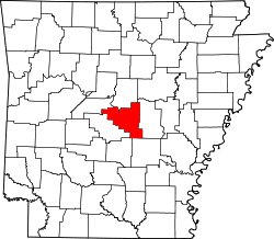
Sweet Home, Arkansas | |
---|---|
Coordinates: 34°40′15″N92°15′02″W / 34.67083°N 92.25056°W | |
Country | United States |
State | Arkansas |
County | Pulaski |
Area | |
• Total | 4.07 sq mi (10.54 km2) |
• Land | 3.89 sq mi (10.07 km2) |
• Water | 0.18 sq mi (0.47 km2) |
Elevation | 305 ft (93 m) |
Population (2020) | |
• Total | 712 |
• Density | 183.03/sq mi (70.67/km2) |
Time zone | UTC-6 (Central (CST)) |
• Summer (DST) | UTC-5 (CDT) |
ZIP code | 72164 |
Area code | 501 |
FIPS code | 05-68330 |
GNIS feature ID | 2402909 [2] |
Sweet Home is a census-designated place (CDP) in Pulaski County, Arkansas, United States. Its population was 849 at the 2010 census. [3] It is part of the 'Little Rock-North Little Rock-AR Metropolitan Statistical Area'.
According to the United States Census Bureau, the CDP has a total area of 4.1 square miles (11 km2), of which 3.9 square miles (10 km2) is land and 0.2 square miles (0.52 km2) (2.72%) is water.
Census | Pop. | Note | %± |
---|---|---|---|
2000 | 1,070 | — | |
2010 | 849 | −20.7% | |
2020 | 712 | −16.1% | |
U.S. Decennial Census [4] |
Race | Number | Percentage |
---|---|---|
White (non-Hispanic) | 150 | 21.07% |
Black or African American (non-Hispanic) | 500 | 70.22% |
Asian | 4 | 0.56% |
Other/Mixed | 26 | 3.65% |
Hispanic or Latino | 32 | 4.49% |
As of the 2020 United States census, there were 712 people, 259 households, and 125 families residing in the CDP.
As of the census [6] of 2000, there were 1,070 people, 385 households, and 267 families residing in the CDP. The population density was 272.0 inhabitants per square mile (105.0/km2). There were 463 housing units at an average density of 117.7 per square mile (45.4/km2). The racial makeup of the CDP was 24.11% White, 74.02% Black or African American, 0.37% Native American, 0.09% Asian, and 1.40% from two or more races. 1.12% of the population were Hispanic or Latino of any race.
There were 385 households, out of which 29.9% had children under the age of 18 living with them, 38.4% were married couples living together, 23.9% had a female householder with no husband present, and 30.4% were non-families. 27.8% of all households were made up of individuals, and 11.2% had someone living alone who was 65 years of age or older. The average household size was 2.78 and the average family size was 3.42.
In the CDP, the population was spread out, with 30.7% under the age of 18, 8.5% from 18 to 24, 25.2% from 25 to 44, 23.0% from 45 to 64, and 12.6% who were 65 years of age or older. The median age was 35 years. For every 100 females, there were 87.7 males. For every 100 females age 18 and over, there were 81.0 males.
The median income for a household in the CDP was $23,352, and the median income for a family was $30,781. Males had a median income of $22,069 versus $21,643 for females. The per capita income for the CDP was $8,868. About 21.7% of families and 25.5% of the population were below the poverty line, including 23.3% of those under age 18 and 60.0% of those age 65 or over.
Most of the geographical history of Sweet Home and the surrounding areas was farms and fields. After bauxite mining between the 1940s through 1960s many blue holes were formed in the Sweet Home Area. [7]
Sweet Home was the site of the Arkansas Confederate Soldiers' Home from 1890 to 1955, but the home was moved to the grounds of the Schools for the Deaf and Blind in Little Rock from 1955 to 1963. [8] The Hanger Cotton Gin is listed on the National Register of Historic Places.
Sweet Home is zoned to College Station Elementary School, Fuller Middle School, and Wilbur D. Mills University Studies High School. [9]
Writer and poet Henry Dumas (1934–1968)
Pulaski County is a county in the U.S. state of Arkansas. With a population of 399,125 as of the 2020 United States Census, it is the most populous county in Arkansas. The county is included in the Little Rock–North Little Rock–Conway metropolitan area. Its county seat is Little Rock, which is also Arkansas's capital and largest city.
Lonoke County is located in the Central Arkansas region of the U.S. state of Arkansas. As of the 2020 census, the population was 74,015, making it the 10th-most populous of Arkansas's 75 counties. The county seat is Lonoke and largest city is Cabot. Included in the Central Arkansas metropolitan area, with Little Rock as the principal city, it is an alcohol prohibition or dry county.
North Crossett is a census-designated place (CDP) in Ashley County, Arkansas, United States. Per the 2020 census, the population was 2,756.
Prairie Creek is a census-designated place (CDP) in Benton County, Arkansas, United States. Per the 2020 census, the population was 2,217. It is a lakefront community adjacent to Beaver Lake and Rogers within the Northwest Arkansas region.
Piney is a census-designated place (CDP) in Garland County, Arkansas, United States. The population was 4,699 at the 2010 census.
Rockwell is a census-designated place (CDP) in Garland County, Arkansas, United States. The population was 3,780 at the 2010 census.
Scott is an unincorporated community and census-designated place (CDP) in Lonoke and Pulaski counties in the central part of the U.S. state of Arkansas. Per the 2020 census, the population was 97. It is part of the Little Rock–North Little Rock–Conway Metropolitan Statistical Area.
Alexander is a city in Pulaski and Saline counties in the U.S. state of Arkansas. Located in Central Arkansas, the town was founded as a construction camp for the nearby railroad. Following its completion, the citizens decided to incorporate in 1887. Alexander is home to the Arkansas Juvenile Assessment and Treatment Center. The population was 2,901 at the 2010 census.
College Station is a census-designated place (CDP) in Pulaski County, Arkansas, United States. The population was 600 at the 2010 census. It is part of the Little Rock–North Little Rock–Conway Metropolitan Statistical Area.
Hensley is a census-designated place (CDP) in Pulaski County, Arkansas, United States. The population was 139 at the 2010 census. It is part of the Little Rock–North Little Rock–Conway Metropolitan Statistical Area.
McAlmont, also referred to as "Mac Side", is a census-designated place (CDP) in Pulaski County, Arkansas, United States. The population was 1,873 at the 2010 census. The community adjoins eastern North Little Rock, and is part of the Little Rock–North Little Rock–Conway Metropolitan Statistical Area.
Landmark is a census-designated place (CDP) in Pulaski County, Arkansas, United States. Per the 2020 census, the population was 3,585. It is part of the Little Rock–North Little Rock–Conway Metropolitan Statistical Area.
Woodson is a census-designated place (CDP) in Pulaski County, Arkansas, United States. Its population was 403 at the 2010 census. It is part of the Little Rock–North Little Rock–Conway Metropolitan Statistical Area. Woodson and its accompanying Woodson Lake and Wood Hollow are the namesake for Ed Wood Sr., a prominent plantation owner, trader, and businessman at the turn of the 20th century. Woodson is adjacent to the Wood Plantation, the largest of the plantations own by Ed Wood Sr.
Wrightsville is a city in Pulaski County, Arkansas, United States. Its population was 1,542 at the 2020 census. It is part of the Little Rock–North Little Rock–Conway Metropolitan Statistical Area. Located on Highway 365, Wrightsville existed as an unincorporated community for more than a century before it was incorporated late in the 20th century. Since 1981, it has been home to a major Arkansas Department of Corrections facility, which is the principal employer.
Orchard Homes is a census-designated place (CDP) in Missoula County, Montana, United States. It is part of the Missoula Metropolitan Statistical Area. The population was 5,377 at the 2020 census.
Dwight Mission is a census-designated place (CDP) in Sequoyah County, Oklahoma, United States. It is part of the Fort Smith, Arkansas-Oklahoma Metropolitan Statistical Area. The population was 55 at the 2010 census, a 71.9 percent gain over the figure of 32 recorded in 2000. It is currently the home of Dwight Mission Presbyterian Camp & Retreat Center.
Rural Hill is a census-designated place (CDP) in Wilson County, Tennessee. The population was 2,132 at the 2010 census.
Stonewall is an unincorporated community and census-designated place (CDP) in Gillespie County, Texas, United States. The population was 525 at the 2010 census. It was named for Confederate General Thomas J. (Stonewall) Jackson, by Israel P. Nunez, who established a stage station near the site in 1870.
Spotsylvania Courthouse is a census-designated place (CDP) and the county seat of Spotsylvania County, Virginia, United States, located 10 miles (16 km) southwest of Fredericksburg. Recognized by the U.S. Census Bureau as a census designated place (CDP), the population was 5,610 at the 2020 census.
Gibson is a census-designated place (CDP) in Pulaski County, Arkansas, United States. The population was 3,543 at the 2010 census. It is part of the Little Rock–North Little Rock–Conway Metropolitan Statistical Area.