Related Research Articles

Pulaski County is a county in the U.S. state of Arkansas. With a population of 399,125 as of the 2020 United States Census, it is the most populous county in Arkansas. The county is included in the Little Rock–North Little Rock–Conway metropolitan area. Its county seat is Little Rock, which is also Arkansas's capital and largest city.

Perry County is a county located in the U.S. state of Arkansas. Its population was 10,019 at the 2020 United States Census. The county seat is Perryville. The county was formed on December 18, 1840, and named for Commodore Oliver Hazard Perry, naval hero in the War of 1812. It is an alcohol prohibition or dry county.

Lonoke County is located in the Central Arkansas region of the U.S. state of Arkansas. As of the 2020 census, the population was 74,015, making it the 10th-most populous of Arkansas's 75 counties. The county seat is Lonoke and largest city is Cabot. Included in the Central Arkansas metropolitan area, with Little Rock as the principal city, it is an alcohol prohibition or dry county.

Mayflower is a city in Faulkner County, Arkansas, United States. The population was 2,234 at the 2010 census, up from 1,631 at the 2000 census. It is located in the Central Arkansas region.

For people with the surname, see Redfield (surname).
Scott is an unincorporated community and census-designated place (CDP) in Lonoke and Pulaski counties in the central part of the U.S. state of Arkansas. Per the 2020 census, the population was 97. It is part of the Little Rock–North Little Rock–Conway Metropolitan Statistical Area.

Jacksonville is a city in Pulaski County, Arkansas, United States, and a suburb of Little Rock. As of the 2010 census, the population of the city was 28,364. It is part of the Little Rock–North Little Rock–Conway Metropolitan Statistical Area with 729,135 people as of 2014.

Sherwood is a city in Pulaski County, Arkansas, United States. As of the 2020 census, the population of the city was 32,731, making it the 13th most populous city in Arkansas. It is part of the Little Rock−North Little Rock−Conway Metropolitan Statistical Area with 699,757 people according to the 2010 census.

Wrightsville is a city in Pulaski County, Arkansas, United States. Its population was 1,542 at the 2020 census. It is part of the Little Rock–North Little Rock–Conway Metropolitan Statistical Area. Located on Highway 365, Wrightsville existed as an unincorporated community for more than a century before it was incorporated late in the 20th century. Since 1981, it has been home to a major Arkansas Department of Corrections facility, which is the principal employer.
Central Arkansas, also known as the Little Rock metro, designated by the United States Office of Management and Budget as the Little Rock-North Little Rock-Conway Metropolitan Statistical Area, is the most populous metro area in the U.S. state of Arkansas. With an estimated 2020 population of 748,031, it is the most populated area in Arkansas. Located at the convergence of Arkansas's other geographic regions, the region's central location make Central Arkansas an important population, economic, education, and political center in Arkansas and the South. Little Rock is the state's capital and largest city, and the city is also home to two Fortune 500 companies, Arkansas Children's Hospital, and University of Arkansas for Medical Sciences (UAMS).

Pulaski Heights is a section of the city of Little Rock, Arkansas, located in the north-central portion of the city. Locally, the area is referred to as the Heights.
Pinnacle Valley is the northwesternmost neighborhood of the city of Little Rock, Arkansas. The area is to the south of Pinnacle Mountain, one of the highest elevations in Pulaski County. Like Chenal Valley which borders the area on its south side, Pinnacle Valley is a fast-developing portion of Little Rock as the city continues to expand westward.

Mabelvale was a small, unincorporated train station town in southwestern Pulaski County, Arkansas, until being annexed into Little Rock following a special election that was held on May 3, 1973. The area today is part of Little Rock's seventh ward, although it retains a separate postal designation and ZIP code [72103] from most of the rest of the city. The neighborhood is currently represented on Little Rock's City Board of Directors by Brenda "B.J." Wyrick.
Pulaski County Special School District No. 1 (PCSSD) is one of four public school districts in Pulaski County, Arkansas—along with the Little Rock School District, the North Little Rock School District, and the Jacksonville North Pulaski School District—accredited by the Arkansas Department of Education. PCSSD has its headquarters in Sweet Home, an unincorporated area near southeastern Little Rock; the headquarters has a Little Rock postal address.

Ouachita National Recreation Trail is a 223-mile (359 km) long, continuous hiking trail through the Ouachita Mountains of Oklahoma and Arkansas. It is the longest backpacking trail in the Ouachita National Forest, spanning 192 miles across its length. Approximately 177 miles of the trail is in Arkansas and 46 miles of the trail is in Oklahoma. The trail is used by hikers, backpackers, hunters, and mountain bikers. It is a non-motorized single track trail open only to foot traffic and partially open to mountain bicycles. Segments opened to mountain bikes are from the western terminus of the Ouachita Trail at Talimena State Park to the Big Cedar trailhead on US Highway 259 at approximately Mile Marker (MM) 30.5 in Oklahoma, and from the Talimena Scenic Drive Trailhead at MM 54.1, east to Highway 7 at mile 160.4, north of Jessieville, Arkansas.

Arkansas's 2nd congressional district is a congressional district located in the central part of the U.S. state of Arkansas and includes the state capital of Little Rock, its suburbs, and surrounding areas. The district leans Republican, with a Cook Partisan Voting Index rating of R+9. However, due to the influence of heavily Democratic Little Rock, it is still considered the least Republican congressional district in Arkansas, which has an all-Republican congressional delegation.

Shinall Mountain is a peak in Pulaski County, Arkansas, located in the foothills of the Ouachita Mountains on the western edge of Little Rock, the capital and most populous city of Arkansas. At an elevation of 1,056 feet (322 m) above mean sea level, it is the highest natural point in Pulaski County. Shinall Mountain is made of Carboniferous rocks, and plant fossils can sometimes be found in the blue-hued black shales comprising the sides of its bluff.

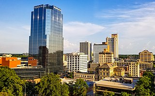
Little Rock is a city in and the capital of the U.S. state of Arkansas, of which it is also its most populous. The city's population was 202,591 as of the 2020 census. The six-county Little Rock metropolitan area is the 81st-most populous in the United States with 748,031 residents according to the 2020 census.

Gibson is a census-designated place (CDP) in Pulaski County, Arkansas, United States. The population was 3,543 at the 2010 census. It is part of the Little Rock–North Little Rock–Conway Metropolitan Statistical Area.
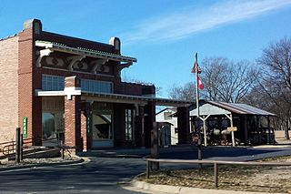
The Plantation Agriculture Museum is a local museum in Scott, Arkansas, on the Pulaski County and Lonoke County line, approximately 12 mi (19 km) east of Little Rock, Arkansas. The museum park is located in the Arkansas River lowlands on the north shore of Horseshoe Lake. The General Store and Post Office buildings are constructed in the Prairie Style of architecture.
References
- ↑ U.S. Geological Survey Geographic Names Information System: Galloway, Arkansas
- ↑ Presley, L. E. (1889). Biographical and historical memoirs of Pulaski County, Arkansas: Comprising a condensed history of the state, a number of biographies of distinguished citizens of the same, a brief descriptive history of each of the counties above named, and numerous biographical sketches of their prominent citizens. The Goodspeed Publishing Company.
Municipalities and communities of Pulaski County, Arkansas, United States | ||
|---|---|---|
| Cities |  | |
| CDPs | ||
| Other unincorporated communities | ||
| Footnotes | ‡This populated place also has portions in an adjacent county or counties | |