Scotland, Arkansas | |
---|---|
Unincorporated community | |
Coordinates: 35°31′39″N92°36′43″W / 35.52750°N 92.61194°W Coordinates: 35°31′39″N92°36′43″W / 35.52750°N 92.61194°W | |
Country | United States |
State | Arkansas |
County | Van Buren |
Elevation | 659 ft (201 m) |
Time zone | Central (CST) (UTC-6) |
• Summer (DST) | CDT (UTC-5) |
ZIP code | 72141 |
GNIS feature ID | 58594 [1] |
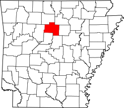
Scotland is an unincorporated community in southwestern Van Buren County, Arkansas, United States, near the head of the South Fork of the Little Red River. In April 2010, a tornado struck this community which resulted in extreme damage.
In law, an unincorporated area is a region of land that is not governed by a local municipal corporation; similarly an unincorporated community is a settlement that is not governed by its own local municipal corporation, but rather is administered as part of larger administrative divisions, such as a township, parish, borough, county, city, canton, state, province or country. Occasionally, municipalities dissolve or disincorporate, which may happen if they become fiscally insolvent, and services become the responsibility of a higher administration. Widespread unincorporated communities and areas are a distinguishing feature of the United States and Canada. In most other countries of the world, there are either no unincorporated areas at all, or these are very rare; typically remote, outlying, sparsely populated or uninhabited areas.
Van Buren County is a county located in the U.S. state of Arkansas. As of the 2010 census, the population was 17,295. The county seat is Clinton. The county was formed on November 11, 1833, and named for Martin Van Buren, President of the United States, who was Vice President at the time of the county's formation. It is an alcohol prohibition or dry county.
Arkansas is a state in the southern region of the United States, home to over 3 million people as of 2017. Its name is of Siouan derivation from the language of the Osage denoting their related kin, the Quapaw Indians. The state's diverse geography ranges from the mountainous regions of the Ozark and the Ouachita Mountains, which make up the U.S. Interior Highlands, to the densely forested land in the south known as the Arkansas Timberlands, to the eastern lowlands along the Mississippi River and the Arkansas Delta.
Public education for elementary and secondary school students is provided by the Clinton School District, which leads students to graduate from Clinton High School.
Clinton School District is a public school district based in Clinton, Arkansas, United States. The district provides early childhood, elementary and secondary education for more than 1,400 prekindergarten through grade 12 students. Students are from 479.18 square miles (1,241.1 km2) of land encompassing Van Buren County and Pope County communities.
Clinton High School is a comprehensive public high school in Clinton, Arkansas, United States that serves grades 10 through 12. It is one of three public high schools in Van Buren County and the only high school managed by the Clinton School District4.
Scotland was a part of the Scotland School District until July 1, 2004, when that district consolidated with the Alread School District into the existing Clinton school district. [2]
Scotland School District was a school district headquartered in Scotland, an unincorporated area in Van Buren County, Arkansas.
Alread School District No. 5 was a school district headquartered in Alread, an unincorporated area in Van Buren County, Arkansas.
Bodcaw is a town in Nevada County, Arkansas, United States. The population was 154 at the 2000 census. It is part of the Hope Micropolitan Statistical Area.
Alread is an unincorporated community in Van Buren County, Arkansas, United States.
Dollarway School District is a school district headquartered in Pine Bluff, Arkansas, United States. With over 1,600 students and employing more than 300 educators and staff, the district currently has three active school campuses.
Kingston is an unincorporated community in northeast Madison County, Arkansas, United States. It is located at the intersection of Arkansas highways 21 and 74. The community is located in the Kings River valley, the stream flows past just to the west of the town.
Briggsville is an unincorporated community in Yell County, Arkansas, United States. Briggsville is located on Arkansas Highway 28, 12 miles (19 km) west-southwest of Plainview. Briggsville has a post office with ZIP code 72828.
Deer is an unincorporated community in Newton County, Arkansas, United States. Deer is located on Arkansas Highway 16, 12.5 miles (20.1 km) south of Jasper. Deer has a post office with ZIP code 72628.
Mount Judea is an unincorporated community in Newton County, Arkansas, United States. Mount Judea is located at the junction of Arkansas highways 74 and 123, 9.5 miles (15.3 km) southeast of Jasper. Mount Judea has a post office with ZIP code 72655.
Witts Springs is an unincorporated community in Searcy County, Arkansas, United States. Witts Springs is located on Arkansas Highway 16, 16.5 miles (26.6 km) southwest of Marshall. Witts Springs has a post office with ZIP code 72686.
Floral is an unincorporated community in Independence County, Arkansas, United States. Floral is located on Arkansas Highway 87, 8 miles (13 km) west-northwest of Pleasant Plains. Floral has a post office with ZIP code 72534.
Jerusalem is an unincorporated community in Conway County, Arkansas, United States. Jerusalem is located on Arkansas Highway 124, 18 miles (29 km) north-northwest of Morrilton. Jerusalem has a post office with ZIP code 72080.
Dollarway High School is a comprehensive public high school in Pine Bluff, Arkansas that serves grades 9 through 12. It is one of three public high schools in Pine Bluff and the only high school managed by the Dollarway School District. Within the state, the school is often referred to as Pine Bluff Dollarway.
Bruno–Pyatt High School is a comprehensive public high school serving students in grades seven through twelve in the remote, rural community of Eros, in unincorporated Marion County, Arkansas, United States, near Everton. It is the one of three high schools administered by the Ozark Mountain School District and the district's only high school in Marion County, Arkansas while supporting the rural communities of Bruno, Pyatt, Everton, and Eros.
Western Grove High School is a comprehensive public high school serving students in grades seven through twelve in the remote, rural community of Western Grove, Arkansas, United States. It is the one of three high schools administered by the Ozark Mountain School District and the district's only high school in Newton County, Arkansas.
Rural Special High School is a comprehensive public high school based in the rural, fringe community of Fox, Arkansas, United States. As one of the smallest schools in the state, the school provides secondary education for students in grades 7 through 12 for the rural, isolated communities of Fox, Meadowcreek, Mozart, Parma, Rushing, Sunnyland, and Turkey Creek. As a result of school district consolidations within the state, Rural Special is one of three high schools consolidated to form the Mountain View School District based in Stone County, Arkansas.
Nemo Vista School District is a public school district based in Center Ridge, Arkansas, United States. The school district encompasses 106.30 square miles (275.3 km2) of land serving all or portions of the Conway County communities of Center Ridge, Springfield, Cleveland, Bee Branch, and Clinton.
Altheimer Unified School District No. 22, previously the Altheimer-Sherrill School District, was a school district headquartered in Altheimer, Arkansas. It served Altheimer, Sherrill, Wabbaseka, and other portions of Jefferson County, including the unincorporated areas of Tucker, Plum Bayou, Pastoria, and Wright.
This Arkansas state location article is a stub. You can help Wikipedia by expanding it. |