National Register of Historic Places listings in Van Buren County, Arkansas

Last updated

Location of Van Buren County in Arkansas Map of Arkansas highlighting Van Buren County.svg
Location of Van Buren County in Arkansas

This is a list of the National Register of Historic Places listings in Van Buren County, Arkansas.

Contents

This is intended to be a complete list of the properties and districts on the National Register of Historic Places in Van Buren County, Arkansas, United States. The locations of National Register properties and districts for which the latitude and longitude coordinates are included below, may be seen in a map. [1]

There are 17 properties and districts listed on the National Register in the county.

Contents: Counties in Arkansas


    This National Park Service list is complete through NPS recent listings posted January 20, 2023. [2]

Map all coordinates using: OpenStreetMap  
Download coordinates as: KML

Current listings

[3] Name on the Register [4] ImageDate listed [5] Location City or townDescription
1 Melvin Chrisco House
Melvin Chrisco House Melvin Chrisco House.JPG
Melvin Chrisco House
September 28, 2005
(#05001082)
237 Alvin Brown Rd.
35°22′13″N92°25′22″W / 35.370278°N 92.422778°W / 35.370278; -92.422778 (Melvin Chrisco House)
Damascus
2 Clinton Commercial Historic District
Clinton Commercial Historic District Clinton Commercial Historic District, 3 of 3.JPG
Clinton Commercial Historic District
May 15, 2006
(#06000410)
Roughly bounded by Town Branch Creek and by U.S. Highway 65B
35°35′43″N92°27′31″W / 35.595278°N 92.458611°W / 35.595278; -92.458611 (Clinton Commercial Historic District)
Clinton
3 Collums-Baker House
Collums-Baker House Collums-Baker House.JPG
Collums-Baker House
November 24, 1992
(#92001282)
Eastern side of U.S. Highway 65, approximately ½ mile south of the community
35°26′38″N92°23′21″W / 35.443889°N 92.389167°W / 35.443889; -92.389167 (Collums-Baker House)
Bee Branch
4 Damascus CCC Camp, Co. No. 3781 Historic District
Damascus CCC Camp, Co. No. 3781 Historic District Damascus CCC Camp, Co. No. 3781 Historic District.JPG
Damascus CCC Camp, Co. No. 3781 Historic District
December 31, 2002
(#02001631)
Camp Hill Rd.
35°22′19″N92°23′32″W / 35.371944°N 92.392222°W / 35.371944; -92.392222 (Damascus CCC Camp, Co. No. 3781 Historic District)
Damascus
5 Damascus Gymnasium
Damascus Gymnasium Damascus Gymnasium.JPG
Damascus Gymnasium
September 4, 1992
(#92001122)
Highway 285
35°22′03″N92°24′36″W / 35.3675°N 92.41°W / 35.3675; -92.41 (Damascus Gymnasium)
Damascus
6 Edgemont Shelter May 4, 1982
(#82002146)
Address Restricted
Shirley
7 Joclin-Bradley-Bowling House
Joclin-Bradley-Bowling House Joclin-Bradley-Bowling House.JPG
Joclin-Bradley-Bowling House
February 1, 2007
(#06001316)
160 Highway 95, W.
35°35′49″N92°27′46″W / 35.596944°N 92.462778°W / 35.596944; -92.462778 (Joclin-Bradley-Bowling House)
Clinton
8 Carl and Esther Lee House
Carl and Esther Lee House Carl and Esther Lee House.JPG
Carl and Esther Lee House
October 19, 2005
(#05001170)
17493 U.S. Highway 65 South
35°22′02″N92°24′29″W / 35.367222°N 92.408056°W / 35.367222; -92.408056 (Carl and Esther Lee House)
Damascus
9 Lynn Creek Shelter March 21, 1978
(#78000634)
Address Restricted
Fairfield Bay
10 Middle Fork of the Little Red River Bridge
Middle Fork of the Little Red River Bridge Middle Fork of the Little Red River Bridge.JPG
Middle Fork of the Little Red River Bridge
January 21, 2010
(#09001260)
County Road 125 over the Middle Fork of the Little Red River
35°39′34″N92°19′20″W / 35.659503°N 92.322094°W / 35.659503; -92.322094 (Middle Fork of the Little Red River Bridge)
Shirley
11 Walter Patterson Filling Station
Walter Patterson Filling Station Walter Patterson Filling Station.JPG
Walter Patterson Filling Station
February 9, 2001
(#01000074)
U.S. Highway 65 between Griggs and Court Sts.
35°35′29″N92°27′26″W / 35.591389°N 92.457222°W / 35.591389; -92.457222 (Walter Patterson Filling Station)
Clinton
12 Walter Patterson House
Walter Patterson House Walter Patterson House.JPG
Walter Patterson House
June 5, 2007
(#07000504)
1800 U.S. Highway 65 North
35°36′42″N92°27′26″W / 35.611667°N 92.457222°W / 35.611667; -92.457222 (Walter Patterson House)
Clinton
13 Art Scanlan House
Art Scanlan House Art Scanlan House.JPG
Art Scanlan House
November 18, 1999
(#99001355)
Route 1,[ clarification needed ] west of U.S. Highway 65
35°26′52″N92°23′38″W / 35.447778°N 92.393889°W / 35.447778; -92.393889 (Art Scanlan House)
Bee Branch
14 South Side High School Sign
South Side High School Sign South Side High School Sign.jpg
South Side High School Sign
January 18, 2023
(#100008573)
334 Southside Rd.
35°25′47″N92°23′19″W / 35.4298°N 92.3886°W / 35.4298; -92.3886 (South Side High School Sign)
Bee Branch vicinity
15 Titan II ICBM Launch Complex 374-7 Site February 18, 2000
(#98001434)
West of U.S. Highway 65, 1.7 miles north of its junction with Highway 124
35°24′51″N92°23′47″W / 35.414167°N 92.396389°W / 35.414167; -92.396389 (Titan II ICBM Launch Complex 374-7 Site)
Southside
16 Van Buren County Courthouse
Van Buren County Courthouse Van Buren County Courthouse.JPG
Van Buren County Courthouse
May 13, 1991
(#91000584)
Junction of Griggs and Main Sts.
35°35′33″N92°27′28″W / 35.5925°N 92.457778°W / 35.5925; -92.457778 (Van Buren County Courthouse)
Clinton
17 Van Buren County Road 2E Bridge
Van Buren County Road 2E Bridge Van Buren County Road 2E Bridge.JPG
Van Buren County Road 2E Bridge
May 5, 1995
(#95000570)
County Road 2E over a tributary of Driver's Creek
35°30′41″N92°41′53″W / 35.511389°N 92.698056°W / 35.511389; -92.698056 (Van Buren County Road 2E Bridge)
Scotland

Former listings

[3] Name on the RegisterImageDate listedDate removedLocationCity or townDescription
1 Stobaugh House July 6, 1976
(#76000471)
March 31, 2000AR 9, 0.5 mi. SW of Choctaw
Choctaw vicinity

See also

Related Research Articles

<span class="mw-page-title-main">National Register of Historic Places listings in St. Joseph County, Michigan</span>

This is a list of the National Register of Historic Places listings in St. Joseph County, Michigan.

<span class="mw-page-title-main">National Register of Historic Places listings in Davis County, Iowa</span>

This is a list of the National Register of Historic Places listings in Davis County, Iowa.

<span class="mw-page-title-main">National Register of Historic Places listings in Jefferson County, Iowa</span>

This is a list of the National Register of Historic Places listings in Jefferson County, Iowa.

<span class="mw-page-title-main">National Register of Historic Places listings in Lee County, Iowa</span>

This is a list of the National Register of Historic Places listings in Lee County, Iowa.

<span class="mw-page-title-main">National Register of Historic Places listings in Van Buren County, Iowa</span>

This is a list of the National Register of Historic Places listings in Van Buren County, Iowa.

<span class="mw-page-title-main">National Register of Historic Places listings in Desha County, Arkansas</span>

This is a list of the National Register of Historic Places listings in Desha County, Arkansas.

<span class="mw-page-title-main">National Register of Historic Places listings in Cleveland County, Arkansas</span>

This is a list of the National Register of Historic Places listings in Cleveland County, Arkansas.

<span class="mw-page-title-main">National Register of Historic Places listings in Independence County, Arkansas</span>

This is a list of the National Register of Historic Places listings in Independence County, Arkansas.

<span class="mw-page-title-main">National Register of Historic Places listings in Marion County, Arkansas</span>

This is a list of the National Register of Historic Places listings in Marion County, Arkansas.

<span class="mw-page-title-main">National Register of Historic Places listings in Lee County, Arkansas</span>

This is a list of the National Register of Historic Places listings in Lee County, Arkansas.

<span class="mw-page-title-main">National Register of Historic Places listings in Lonoke County, Arkansas</span>

This is a list of the National Register of Historic Places listings in Lonoke County, Arkansas.

<span class="mw-page-title-main">National Register of Historic Places listings in Logan County, Arkansas</span>

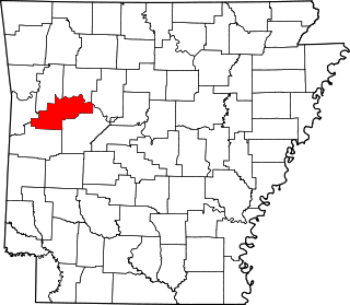
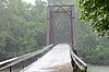
This is a list of the National Register of Historic Places listings in Logan County, Arkansas.

<span class="mw-page-title-main">National Register of Historic Places listings in Ouachita County, Arkansas</span>

This is a list of the National Register of Historic Places listings in Ouachita County, Arkansas.

<span class="mw-page-title-main">National Register of Historic Places listings in Phillips County, Arkansas</span>

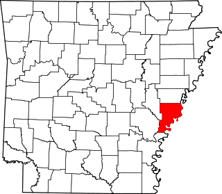
This is a list of the National Register of Historic Places listings in Phillips County, Arkansas.

<span class="mw-page-title-main">National Register of Historic Places listings in Miller County, Arkansas</span>

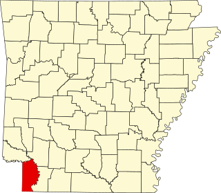
This is a list of the National Register of Historic Places listings in Miller County, Arkansas.

<span class="mw-page-title-main">National Register of Historic Places listings in Pope County, Arkansas</span>

This is a list of the National Register of Historic Places listings in Pope County, Arkansas.

<span class="mw-page-title-main">National Register of Historic Places listings in Sharp County, Arkansas</span>

This is a list of the National Register of Historic Places listings in Sharp County, Arkansas.

<span class="mw-page-title-main">National Register of Historic Places listings in Searcy County, Arkansas</span>

This is a list of the National Register of Historic Places listings in Searcy County, Arkansas.

<span class="mw-page-title-main">National Register of Historic Places listings in Stone County, Arkansas</span>

This is a list of the National Register of Historic Places listings in Stone County, Arkansas.

<span class="mw-page-title-main">National Register of Historic Places listings in White County, Arkansas</span>

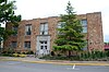
This is a list of the National Register of Historic Places listings in White County, Arkansas.

References

  1. The latitude and longitude information provided in this table was derived originally from the National Register Information System, which has been found to be fairly accurate for about 99% of listings. Some locations in this table may have been corrected to current GPS standards.
  2. National Park Service, United States Department of the Interior, "National Register of Historic Places: Weekly List Actions", retrieved January 20, 2023.
  3. 1 2 Numbers represent an alphabetical ordering by significant words. Various colorings, defined here, differentiate National Historic Landmarks and historic districts from other NRHP buildings, structures, sites or objects.
  4. "National Register Information System". National Register of Historic Places . National Park Service. March 13, 2009.
  5. The eight-digit number below each date is the number assigned to each location in the National Register Information System database, which can be viewed by clicking the number.