National Register of Historic Places listings in Little River County, Arkansas

Last updated
Location of Little River County in Arkansas Map of Arkansas highlighting Little River County.svg
Location of Little River County in Arkansas

This is a list of the National Register of Historic Places listings in Little River County, Arkansas.

Contents

This is intended to be a complete list of the properties and districts on the National Register of Historic Places in Little River County, Arkansas, United States. The locations of National Register properties and districts for which the latitude and longitude coordinates are included below, may be seen in a map. [1]

There are 16 properties and districts listed on the National Register in the county, and one former listing.

Contents: Counties in Arkansas
This National Park Service list is complete through NPS recent listings posted April 3, 2020. [2]
Map all coordinates using: OpenStreetMap  
Download coordinates as: KML  ·  GPX

Current listings

[3] Name on the Register [4] ImageDate listed [5] Location City or townDescription
1 Anderson-Hobson Mercantile Store
Anderson-Hobson Mercantile Store Anderson-Hobson Mercantile Store.JPG
Anderson-Hobson Mercantile Store
June 20, 1996
(#96000642)
201 Schuman St.
33°43′19″N94°23′49″W / 33.721944°N 94.396944°W / 33.721944; -94.396944 (Anderson-Hobson Mercantile Store)
Foreman
2 Ashdown Commercial Historic District
Ashdown Commercial Historic District Ashdown Commercial Historic District, 2 of 3.JPG
Ashdown Commercial Historic District
May 20, 2008
(#08000439)
Roughly bounded by Keller, E. Main Commerce, and N. Constitution Sts.
33°40′27″N94°07′52″W / 33.6741°N 94.1311°W / 33.6741; -94.1311 (Ashdown Commercial Historic District)
Ashdown
3 Judge Jefferson Thomas Cowling House
Judge Jefferson Thomas Cowling House Judge Jefferson Thomas Cowling House.JPG
Judge Jefferson Thomas Cowling House
December 8, 1988
(#88002823)
611 Willow St.
33°40′44″N94°07′44″W / 33.678889°N 94.128889°W / 33.678889; -94.128889 (Judge Jefferson Thomas Cowling House)
Ashdown
4 Hawkins House
Hawkins House Hawkins House, Foreman, AR.JPG
Hawkins House
June 20, 1996
(#96000641)
Northwestern corner of the junction of 3rd Ave. and 3rd St.
33°43′24″N94°24′03″W / 33.723333°N 94.400833°W / 33.723333; -94.400833 (Hawkins House)
Foreman
5 Hunter-Coulter House
Hunter-Coulter House Hunter-Coulter House.JPG
Hunter-Coulter House
June 20, 1996
(#96000633)
Northwestern corner of the junction of 2nd and Commerce Sts.
33°40′21″N94°07′56″W / 33.6725°N 94.132222°W / 33.6725; -94.132222 (Hunter-Coulter House)
Ashdown
6 Little River County Courthouse
Little River County Courthouse Ashdown August 2018 29 (Little River County Courthouse).jpg
Little River County Courthouse
September 29, 1976
(#76000427)
Main and 2nd Sts.
33°40′20″N94°07′58″W / 33.672222°N 94.132778°W / 33.672222; -94.132778 (Little River County Courthouse)
Ashdown 1907 neoclassical-style courthouse
7 Little River County Training School Historic District
Little River County Training School Historic District Little River County Training School Historic District.jpg
Little River County Training School Historic District
January 26, 2016
(#15000994)
100 W. Hamilton St.
33°40′07″N94°07′59″W / 33.668553°N 94.133104°W / 33.668553; -94.133104 (Little River County Training School Historic District)
Ashdown
8 Memphis, Paris and Gulf Railroad Depot
Memphis, Paris and Gulf Railroad Depot Ashdown August 2018 07 (Memphis, Paris and Gulf Railroad Depot).jpg
Memphis, Paris and Gulf Railroad Depot
March 17, 1994
(#94000192)
Northern corner of the junction of Whitaker Ave. and Frisco St.
33°40′26″N94°07′42″W / 33.673889°N 94.128333°W / 33.673889; -94.128333 (Memphis, Paris and Gulf Railroad Depot)
Ashdown
9 Mills Cemetery
Mills Cemetery Mills Cemetery, Wilton, AR.JPG
Mills Cemetery
September 27, 2007
(#07000992)
County Road 40, approximately 18-mile west of U.S. Route 71, N.
33°46′22″N94°09′05″W / 33.772778°N 94.151389°W / 33.772778; -94.151389 (Mills Cemetery)
Wilton
10 New Rocky Comfort Jail
New Rocky Comfort Jail New Rocky Comfort Jail.JPG
New Rocky Comfort Jail
December 9, 1994
(#94001465)
Southeastern corner of the junction of 3rd and Schuman Sts.
33°43′22″N94°23′46″W / 33.722778°N 94.396111°W / 33.722778; -94.396111 (New Rocky Comfort Jail)
Foreman
11 Old US 71-Ashdown Segment
Old US 71-Ashdown Segment Old US 71-Ashdown Segment.JPG
Old US 71-Ashdown Segment
January 29, 2013
(#12001232)
N. Park Ave. between E. Main St. & US 71
33°40′46″N94°07′56″W / 33.67939°N 94.132129°W / 33.67939; -94.132129 (Old US 71-Ashdown Segment)
Ashdown
12 Old US 71-Ogden Segment
Old US 71-Ogden Segment Old US 71-Ogden Segment.jpg
Old US 71-Ogden Segment
January 29, 2013
(#12001230)
Ogden & Grand Sts., west of US 71 & east of Kansas City Southern Railroad
33°34′58″N94°02′33″W / 33.582663°N 94.042565°W / 33.582663; -94.042565 (Old US 71-Ogden Segment)
Ogden
13 Old US 71-Wilton Segment
Old US 71-Wilton Segment Old US 71-Wilton Segment.JPG
Old US 71-Wilton Segment
May 26, 2004
(#04000492)
East of U.S. Route 71 from Old U.S. Route 71 and the U.S. Route 71 junction north to the southern bank of the Little River
33°46′04″N94°08′49″W / 33.767778°N 94.146944°W / 33.767778; -94.146944 (Old US 71-Wilton Segment)
Wilton
14 Will Reed Farm House
Will Reed Farm House Will Reed Farm House.JPG
Will Reed Farm House
July 14, 1978
(#78000606)
Main St.
33°46′20″N94°15′36″W / 33.772222°N 94.26°W / 33.772222; -94.26 (Will Reed Farm House)
Alleene
15 St. Barnabas Episcopal Church
St. Barnabas Episcopal Church St. Barnabas Episcopal Church, Foreman, AR, 1 of 4.JPG
St. Barnabas Episcopal Church
July 23, 1998
(#98000910)
Junction of Tracy Lawrence Ave. and Bell St.
33°43′51″N94°23′43″W / 33.730833°N 94.395278°W / 33.730833; -94.395278 (St. Barnabas Episcopal Church)
Foreman
16 Texarkana and Fort Smith Railway Depot
Texarkana and Fort Smith Railway Depot Texarkana and Fort Smith Railway Depot.JPG
Texarkana and Fort Smith Railway Depot
January 24, 2008
(#07001428)
Texarkana Ave.
33°44′32″N94°08′56″W / 33.742222°N 94.148889°W / 33.742222; -94.148889 (Texarkana and Fort Smith Railway Depot)
Wilton

Former listing

[3] Name on the RegisterImageDate listedDate removedLocationCity or townSummary
1 S.S.P. Mills and Son Building
S.S.P. Mills and Son Building S.S.P. Mills and Son Building, mid-demolition.JPG
S.S.P. Mills and Son Building
June 20, 1996
(#96000631)
January 27, 2014Northwestern corner of the junction of Texarkana Ave. and Main St.
33°44′25″N94°08′54″W / 33.740278°N 94.148333°W / 33.740278; -94.148333 (S.S.P. Mills and Son Building)
Wilton

See also

Related Research Articles

National Register of Historic Places listings in Pulaski County, Arkansas Wikimedia list article

This is a list of the National Register of Historic Places listings in Pulaski County, Arkansas.

National Register of Historic Places listings in Boone County, Arkansas Wikimedia list article

This is a list of the National Register of Historic Places listings in Boone County, Arkansas.

National Register of Historic Places listings in Arkansas County, Arkansas Wikimedia list article

This is a list of the National Register of Historic Places listings in Arkansas County, Arkansas.

National Register of Historic Places listings in Benton County, Arkansas Wikimedia list article

This is a list of the National Register of Historic Places listings in Benton County, Arkansas.

National Register of Historic Places listings in Desha County, Arkansas Wikimedia list article

This is a list of the National Register of Historic Places listings in Desha County, Arkansas.

National Register of Historic Places listings in Garland County, Arkansas

This is a list of the National Register of Historic Places listings in Garland County, Arkansas.

National Register of Historic Places listings in Dallas County, Arkansas Wikimedia list article

This is a list of the National Register of Historic Places listings in Dallas County, Arkansas.

National Register of Historic Places listings in Clay County, Arkansas Wikimedia list article

This is a list of the National Register of Historic Places listings in Clay County, Arkansas.

National Register of Historic Places listings in Greene County, Arkansas Wikimedia list article

This is a list of the National Register of Historic Places listings in Greene County, Arkansas.

National Register of Historic Places listings in Izard County, Arkansas Wikimedia list article

This is a list of the National Register of Historic Places listings in Izard County, Arkansas.

National Register of Historic Places listings in Independence County, Arkansas Wikimedia list article

This is a list of the National Register of Historic Places listings in Independence County, Arkansas.

National Register of Historic Places listings in Jefferson County, Arkansas Wikimedia list article

This is a list of the National Register of Historic Places listings in Jefferson County, Arkansas.

National Register of Historic Places listings in Logan County, Arkansas Wikimedia list article

This is a list of the National Register of Historic Places listings in Logan County, Arkansas.

National Register of Historic Places listings in Perry County, Arkansas Wikimedia list article

This is a list of the National Register of Historic Places listings in Perry County, Arkansas.

National Register of Historic Places listings in Ouachita County, Arkansas Wikimedia list article

This is a list of the National Register of Historic Places listings in Ouachita County, Arkansas.

National Register of Historic Places listings in Polk County, Arkansas Wikimedia list article

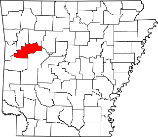
This is a list of the National Register of Historic Places listings in Polk County, Arkansas.

National Register of Historic Places listings in Searcy County, Arkansas Wikimedia list article

This is a list of the National Register of Historic Places listings in Searcy County, Arkansas.

National Register of Historic Places listings in Union County, Arkansas

This is a list of the National Register of Historic Places listings in Union County, Arkansas.

National Register of Historic Places listings in White County, Arkansas Wikimedia list article

This is a list of the National Register of Historic Places listings in White County, Arkansas.

National Register of Historic Places listings in Little Rock, Arkansas Wikimedia list article

This is a list of the National Register of Historic Places listings in Little Rock, Arkansas.

References

  1. The latitude and longitude information provided in this table was derived originally from the National Register Information System, which has been found to be fairly accurate for about 99% of listings. Some locations in this table may have been corrected to current GPS standards.
  2. "National Register of Historic Places: Weekly List Actions". National Park Service, United States Department of the Interior. Retrieved on April 3, 2020.
  3. 1 2 Numbers represent an ordering by significant words. Various colorings, defined here, differentiate National Historic Landmarks and historic districts from other NRHP buildings, structures, sites or objects.
  4. "National Register Information System". National Register of Historic Places . National Park Service. March 13, 2009.
  5. The eight-digit number below each date is the number assigned to each location in the National Register Information System database, which can be viewed by clicking the number.